| |
Temperatures |
Precipitation |
| Site |
Max |
Min |
Avg |
Norm |
Dep |
Hi |
Lo |
Sum |
Norm |
Dep |
| Fayetteville (NW AR) |
90.0 |
69.0 |
79.5 |
77.9 |
+1.6 |
99 |
57 |
5.99 |
3.80 |
+2.19 |
| Harrison (NC AR) |
87.7 |
67.1 |
77.4 |
78.5 |
-1.1 |
98 |
58 |
7.12 |
3.54 |
+3.58 |
| Jonesboro (NE AR) |
88.6 |
71.7 |
80.2 |
81.7 |
-1.5 |
98 |
65 |
4.23 |
3.69 |
+0.54 |
| Fort Smith (WC AR) |
92.9 |
73.3 |
83.1 |
83.1 |
0.0 |
102 |
66 |
5.24 |
3.39 |
+1.85 |
| Little Rock (C AR) |
90.8 |
73.9 |
82.3 |
81.5 |
+0.8 |
100 |
68 |
5.21 |
3.23 |
+1.98 |
| Texarkana (SW AR) |
93.6 |
75.1 |
84.4 |
82.5 |
+1.9 |
102 |
67 |
7.16 |
3.24 |
+3.92 |
| El Dorado (SC AR) |
90.9 |
71.1 |
81.0 |
82.5 |
-1.5 |
99 |
63 |
4.15 |
3.32 |
+0.83 |
| Pine Bluff (SE AR) |
90.8 |
73.2 |
82.0 |
81.9 |
+0.1 |
100 |
66 |
3.08 |
3.58 |
-0.50 |
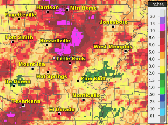
Monthly temperatures varied across the state with rainfall generally well above normal.
| |
| Temperature records broken in July. Check out the records below. |
| Site |
Record High (Date of Occurrence) |
| Mount Ida |
99T, (7/4) |
| Site |
Record Low (Date of Occurrence) |
| Mount Ida |
60T, (7/20) |
| North Little Rock |
67T, (7/9) 65T, (7/20) |
| Russellville |
61T, (7/20) |
|
|
| In the video: A visible satellite image loop shows Beryl making its way across the Gulf of America. |
|
| |
|
Active weather was fairly limited during the month of July across Arkansas, but impacts from the remnants of Beryl and a separate heavy rainfall event during the middle of the month were quite noteworthy.
|
|
|
| In the picture: A radar snapshot from the afternoon of July 8th shows tornado warnings in effect across east Texas and northwest Louisiana. This activity would extend north into Arkansas through the evening hours of the 8th. |
|
| |
|
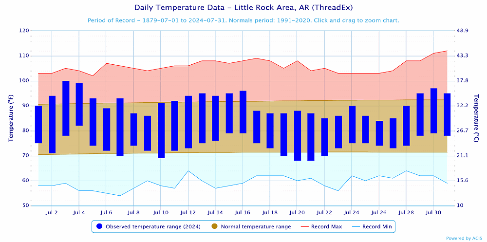
It was quite hot the first few days of the month with some rain observed across northern Arkansas. Little Rock hit 100° on July 3rd and 99° on the 4th with several other locations also recording highs around 100°. Rain and storm coverage was a little more widespread from the evening of the 4th through the morning of the 5th as a cold front pushed south into the state. Some parts of the state picked up over an inch of rain, while many places missed out still.
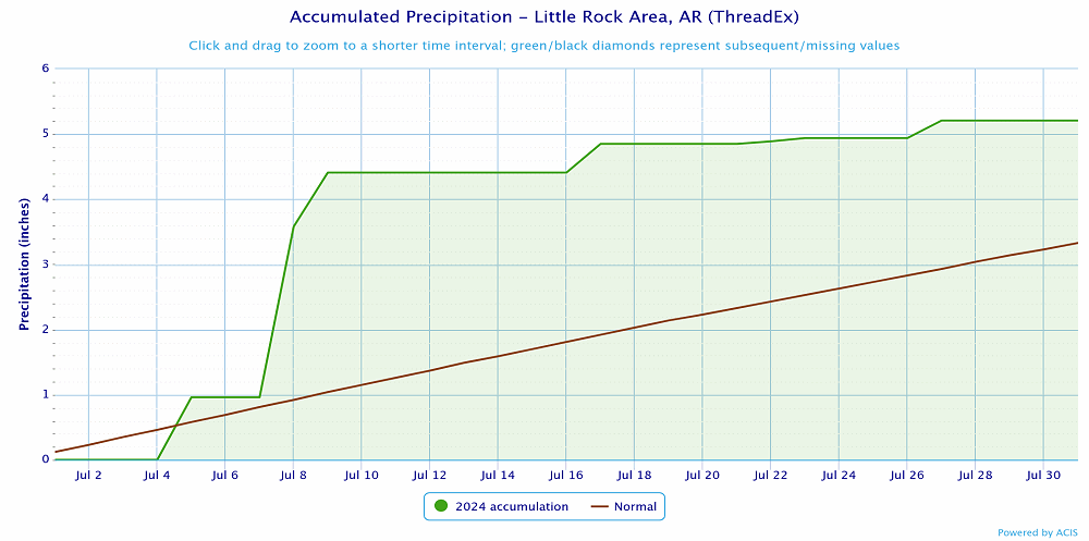
The remnants of Beryl moved across the state from the 8th into the 9th. Several tornadoes developed across portions of southern Arkansas with heavy rainfall also noted. While it was quite busy across much of Arkansas, there were even more tornadoes seen across areas just to the south and west. Dozens of tornadoes touched down across portions of east Texas and northwest Louisiana on July 8th.
|
|
Dry conditions and warming temperatures were seen into the middle of July. By the 14th some heat advisories were needed for heat index values of 105 or higher. The heat peaked from the 16th through 17th just before a cold front moved across the state.
As a cold front moved across the state a few severe storms developed across northern Arkansas during the evening of the 16th which produced some hail and damaging winds. Continuing through the overnight into the early morning hours, rain continued to develop across north central Arkansas. An axis of heavy rain stretched from the AR/MO border south into central Arkansas. The heaviest amounts fell across portions of Searcy, Marion, Baxter, Stone and Cleburne Counties. A flash flood emergency was issued for areas around Yellville where some of the worst flooding occurred.
|
|
In the wake of the heavy rainfall event on the 16th and 17th, drier weather and cooler temperatures were seen. The coolest temperatures were seen during the mornings of the 19th and 20th when lows dipped down into the 50s across northern and western Arkansas, 60s were noted elsewhere. A few record low temperatures were tied.
Rain returned to the state from west to east on the 21st with several rainy days afterward. In addition to the clouds and rainfall, temperatures remained below normal through much of the end of the month.
By the 29th, rain began to shutoff and the heat began to expand east across the state.
|
 |
| In the picture: Temperatures at Little Rock (Pulaski County). Click to enlarge. |
|
 |
| In the picture: Precipitation at Little Rock (Pulaski County). Click to enlarge. |
|
 |
| In the picture: Precipitation across Arkansas. |
|
|
|