|
| Yearly Reports |
| Interested in what kind of weather occurred in a recent year? Check out the most memorable events below. |
|
|
 |
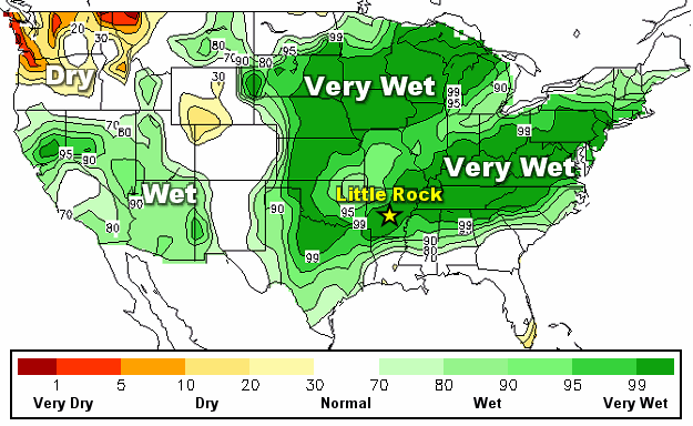
Arkansas Yearly Climate Summary (2019)/Pg3 |
 |
| |
| Significant Events Across the Country |
|
|
| |
|
The year began with a storm system approaching the middle of the country from the southwest on January 11th. Mainly rain fell in Arkansas, with a winter storm unfolding to the north.
|
|
|
| In the picture: By 900 pm CST on 01/12/2019, more than a foot of snow dumped in parts of central and eastern Missouri. |
|
| |
|
It was cold enough to support heavy snow from Missouri to Indiana. By the morning of the 12th, parts of central and eastern Missouri received up to a foot of snow. As of 900 pm CST, a whopping 20 to 21 inches of powder piled up at the University of Missouri (in Columbia, MO), with 19 inches at Mexico, MO, 17 inches at Fulton, MO, and 15 inches at Jefferson City, MO.
|
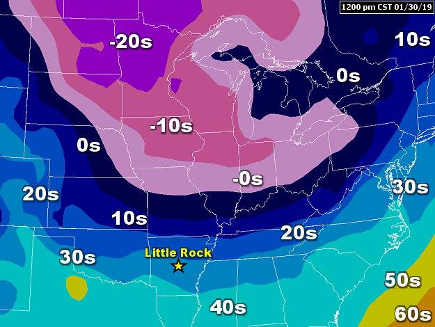 |
| In the picture: Temperatures were 20 degrees below zero or colder in parts of North Dakota, South Dakota, Minnesota, and Wisconsin at 1200 pm CST on 01/30/2019. |
|
| |
|
The month finished with some of the coldest air of the winter and well below zero temperatures from the Dakotas to the Ohio Valley on the 30th. Subzero readings were experienced as far south as St. Louis, MO and Cincinnati, OH.
The low temperature at Chicago, IL was 23 degrees below zero on the 30th. The last time it was this cold was in January, 1985. The high for the day was only 10 below zero. Early on the 31st, an all-time record low was established at Rockford, IL. It was 30 degrees below zero, surpassing the previous mark of 27 degrees below zero on January 10, 1982.
It was cold enough to declare a state of emergency in Illinois, Michigan, and Wisconsin. Numerous schools and universities were closed. Thousands of flights were delayed or cancelled.
|
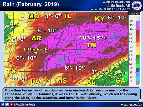 |
| In the picture: More than ten inches of rain was common from eastern Arkansas to much of the Tennessee Valley in February, 2019. |
|
| |
|
In February, it was all about the rain and too much of it. For the month, ten to more than fifteen inches of rain dumped in Tennessee. Late in the month, a state of emergency was declared due to flood issues. There was major flooding in Columbia, TN as the Duck River crested ten feet above the flood stage. The Tennessee River was on its way to the second highest level (since 1897) at Perryville, TN. A mudslide in Chattanooga, TN flattened a sandwich shop. The two to three inches of rain that Nashville, TN got on the 22nd/23rd pushed the monthly total to 13.47 inches. This made it the wettest February on record in the city (breaking the previous high mark of 12.37 inches in 1880).
To the north, there was moderate to heavy snow east of Kansas City on the 15th, with temperatures in the teens at 1100 am CST. Roads were snow covered and hazardous, and a huge pileup resulted on Interstate 70. A total of 47 cars and trucks were involved. The highway had to be closed for seven hours. One person was killed.
There had never been so much snow at Minneapolis, MN in February. A staggering 39.0 inches of snow was measured. A monthly snowfall record was also set at Omaha, NE, with 27.0 inches of snow accumulating.
|
|
|
| In the pictures: Homes were completely destroyed in southwest Lee County, AL (about 10 miles south of Opelika, AL) by a tornado (rated EF4/170 mph winds) on 03/03/2019. Survey results and photos are courtesy of the National Weather Service Birmingham, AL. |
|
| |
|
One of the biggest stories of the spring was a tornado outbreak across the southeast United States in early March. There were over three dozen reports of tornadoes, with most of these in Alabama, Georgia, and the Florida panhandle. The most devastating tornado affected Lee County, AL.
From south of Opelika, AL to Smiths Station, AL (both in Lee County), at least 23 fatalities were reported. Damage was extensive, with the tornado given an EF4 rating by the National Weather Service in Birmingham, AL. Across the country, it was the first tornado of at least this magnitude since April, 2017. It was the deadliest tornado since the EF5 monster that ripped through Moore, OK and killed 24 people in May, 2013. Unfortunately, the story didn't end in Alabama. The tornado crossed into Georgia, and eventually tore through the town of Talbotton, GA (30 miles northeast of Columbus, GA). Homes and businesses were leveled. The tornado covered a whopping 69 miles before finally dissipating!
|
|
|
| In the picture: The pressure at Dodge City, KS bottomed out at the lowest level in more than a century on 03/13/2019. |
|
| |
|
In mid-March, a massive storm system developed in eastern Colorado. The system bombed out (rapidly intensified) on the 13th, with its central pressure plummeting more than 24 millibars in 24 hours. As this happened, records were broken.
The pressure at Dodge City, KS dropped to 974.6 millibars, which was the lowest pressure since 1900 locally. It appears an all-time low pressure mark was established for the state of Colorado at La Junta, CO (971.7 mb).
Surrounding such an intense system, it was very windy. A 97 mph gust was measured in Colorado Springs, CO, with a 103 mph gust at Pine Springs, TX. Twenty six rail cars were blown off of a bridge near Logan, NM. No injuries were reported.
|
|
|
| In the picture: Soil moisture was well above average (30 to 70 percent) in many areas east of the Rockies on 03/18/2019. |
|
| |
|
This system also wrung out two to more than three inches of rain in Nebraska. While this does not sound like much, soil moisture levels were already extreme (due to above average precipitation and melting snow). There were also ice jams (and water backing up) along tributaries. Throw in additional downpours, and you have a huge problem.
|
|
|
| In the picture: Employees at the National Weather Service (NWS) in Omaha, NE teamed up with colleagues at NWS Hastings, NE to handle record setting flooding across the state on 03/16/2019. |
|
| |
|
Flooding became widespread, with record crests on several rivers. Whole towns were swallowed by rising water. The Governor called it one of the worst natural disasters in the state's history. Water surrounded the National Weather Service building in Valley, NE (just west of Omaha, NE). Employees were forced to evacuate, and relocated to Hastings, NE to continue forecast and warning operations.
|
|
|
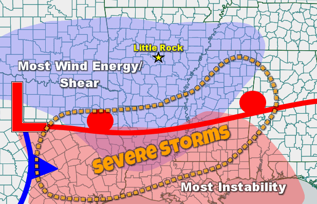
| In the picture: Ahead of a storm system ("L") in Texas on 04/13/2019, very mild and unstable air was noted south of a warm front (red line) along the Gulf Coast. Farther north, there was a lot of wind energy, and winds turned with height (shear). Severe weather was most likely where the most wind energy phased with the most instability. |
|
| |
|
In April, severe weather hinged on the placement of a warm front on the 13th. Tornadoes were in the forecast along and south of the front where it was warm and unstable. There was also a lot of shear (winds turning with height).
The front almost made it into Arkansas (from the Gulf Coast), with a nightmare unfolding to the south. Tornadoes (mostly rated EF2/EF3) ripped through Franklin, TX, Alto, TX, Vicksburg, MS, and Hamilton, MS, and caused extensive damage. Several people were killed, and there were dozens of injuries. In West Monroe, LA, a teenage boy was swept into a drainage ditch by high water and drowned.
|
|
|
| |
|
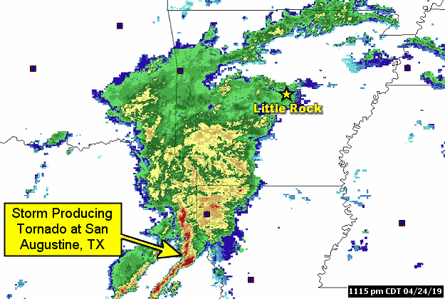
Less than two weeks later (on the 24th), tornadoes were back in eastern Texas. A tornado (rated EF2) tore through San Augustine, TX around 1115 pm CDT. Homes and businesses were damaged or destroyed. The same storm that was responsible for the chaos produced another tornado (rated EF3) in Ruston, LA by 150 am CDT on the 25th. Louisiana Tech University took a direct hit. Two fatalities (a mother and her teenage son) resulted when a tree fell through a home. By 300 am CDT, a third tornado (rated EF2) headed into Arkansas from Louisiana and affected areas just south of Crossett (Ashley County).
|
|
|
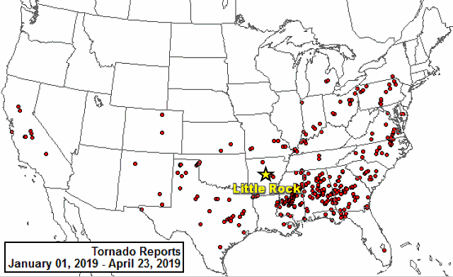
| In the picture: Tornado reports in 2019 (through 04/23). The graphic is courtesy of the Storm Prediction Center. |
|
| |
|
Up to this point, dozens of tornadoes were counted to the south/east of Arkansas. Only a handful of tornadoes happened here at home, with heavy to excessive rain dominating the headlines.
|
|
|
| In the video: It was a sign of things to come in Arkansas on 05/26/2019. Just west of Fort Smith (Sebastian County), there was water everywhere in Moffett, OK as the Arkansas River climbed to record levels. The video is courtesy of Brian Emfinger via Twitter. |
|
| |
|
The Mississippi River was high through the first four months of 2019, and this continued into May. On May 21st, the river had been above flood stage for 136 days (since January 5th) at Baton Rouge, LA. This was the longest streak above flood stage in recorded history (surpassing the 135 day mark established during the Great Flood of 1927).
|
|
|
| In the video: It was a sign of things to come in Arkansas on 05/26/2019. Just west of Fort Smith (Sebastian County), there was water everywhere in Moffett, OK as the Arkansas River climbed to record levels. The video is courtesy of Brian Emfinger via Twitter. |
|
| |
|
The next day (May 22nd), the Arkansas River was wreaking havoc in Webbers Falls, OK. Residents were urged to evacuate as water inundated large tracts of land and engulfed homes. During the evening, the river reached its second highest level on record at Muskogee, OK.
|
 |
| In the picture: The 500 millibar (18,000 feet) map showed a ridge of high pressure ("H") building over the southeast United States at 100 am CDT on 05/23/2019. Storm systems ("L") were forced to go around the periphery of the high and away from Arkansas. |
|
| |
|
At this time, a big ridge of high pressure was over the southeast United States. The high shut off rain in Arkansas temporarily, with warm and dry conditions for several days. Storm systems and active weather were forced to go around the high and away from the region. This led to a relentless period severe weather from the Plains to the mid-Mississippi and Ohio Valleys.
|
|
|
| In the pictures: A powerful tornado (rated EF4) cut a thirty two mile swath through portions of eastern Kansas on 05/28/2019. The information is courtesy of the National Weather Service in Pleasant Hill, MO via Twitter. |
|
| |
|
Powerful tornadoes (rated EF3/EF4) were spawned from the 23rd through the 28th in Jefferson City, MO, El Reno, OK, Dayton, OH, and Lawrence, KS. On Memorial Day (May 27th), twenty tornadoes raked through Ohio. This was more tornadoes than on any other day on record in the state.
|
|
|
| In the video: A satellite loop showed a large area of showers and thunderstorms heading from northern into central Arkansas during the afternoon of 06/23/2019. At 300 pm CDT, the leading edge of the precipitation was as far south as Augusta (Woodruff County), Little Rock (Pulaski County), and Mount Ida (Montgomery County). |
|
| |
|
In June, more than a half foot of rain dumped in portions of northern and western Arkansas and southwest Missouri on June 23rd. Flooding was horrible around Anderson, MO. Overflowing creeks and streams flowed into homes, with only roofs visible in some cases. Torrents of water flowed across major thoroughfares, completely paralyzing traffic. One woman was missing after her home was swept away.
|
| Link of Interest |
| (courtesy of Charles Peek via Twitter) |
|
|
| In the video: Hurricane Dorian became a Category 4 storm with 130 mph sustained winds during the evening of 08/30/2019. |
|
| |
|
In late August, at least four feet of snow piled up at Browning, MT on the 28th/29th. Wind gusts from 30 to 35 mph created drifts as high as houses. At Billings, MT, 19.3 inches of snow accumulated. It was the second highest two day total on record.
About the same time, the tropics were alive with a catastrophic hurricane nearing the Bahamas and stalling. Hurricane Dorian became a Category 4 storm by August 30th, with 130 mph sustained winds. Speeds were up to 150 mph late on the 31st, and topped out at 185 mph (Category 5) as September began. Massive destruction occurred in the Abaco and Grand Bahama Islands. Over 70,000 people were left homeless. By the 6th, Dorian made its way to the Outer Banks of North Carolina as a Category 1 storm (90 mph sustained winds). The storm unleashed 10 to 15 inches of rain at many locations from near Charleston, SC to Hatteras, NC. The system went on to batter Nova Scotia, with at least 400,000 power outages reported.
|
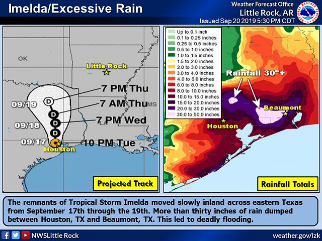 |
| In the picture: The remnants of Tropical Storm Imelda were projected to remain over eastern Texas for at least a couple of days as of 1000 pm CDT on 09/17/2019. More than thirty inches of rain dumped between Houston, TX and Beaumont, TX. |
|
| |
|
In the Gulf of America, Tropical Storm Imelda was ready to slam into the Texas Gulf Coat in mid-September. There were some impressive rainfall totals. A few spots between Houston, TX and Beaumont, TX received more than three feet of liquid! Much of this dumped in twenty four hours. Some homes that were flooded in August, 2017 by Hurricane Harvey were endangered by high water again. Hundreds of vehicles were abandoned and more than a thousand people were rescued. At least five people were killed.
The 9.21 inches of rain in Houston, TX on the 19th made it the wettest September calendar day in the city. It was also the 5th wettest calendar day for any month.
|
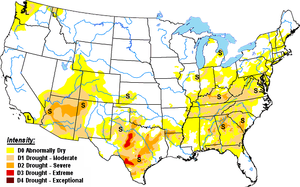 |
| In the picture: Drought conditions as of 09/24/2019. |
|
| |
|
Away from the tropics, a lack of rain and record heat led to a flash (rapidly expanding and worsening) drought across the southern states. From Alabama and Florida to Virginia, moderate drought (D1) conditions affected 6 percent of a six state area on the 3rd. By the 24th, the coverage increased to 38 percent. In Kentucky and Tennessee, the D1 area went from less than 2 percent to around 60 percent in three weeks.
|
|
|
| In the picture: The number of tornadoes across Oklahoma as of 10/21/2019 was closing in on a state record set in 1999. |
|
| |
|
In October, a powerful tornado (rated EF3) ripped up buildings and cut power to at least 150,000 customers on the north side of Dallas, TX between 1000 pm and 1100 pm CDT on the 20th. Fortunately, there were no fatalities. This was one of almost a dozen tornadoes in Texas. In southwest Missouri, seven tornadoes were spawned.
Five twisters in eastern Oklahoma on October 20th/21st pushed the annual total to 146. This eclipsed the previous record of 145 tornadoes set in 1999.
|
|
|
| In the picture: More than a half foot of snow accumulated in the Texas panhandle on 10/24/2019. |
|
| |
|
A few days later, it was cold enough for snow in parts of the Texas panhandle and into southwest Oklahoma. On the 24th, 5.5 inches of snow piled up at Amarillo, TX. There was double the snow (11 inches) in Arnett, OK.
On the afternoon of the 25th, Tropical Storm Olga spun up briefly off the Louisiana coast. The remnants of Olga produced wind damage in parts of Mississippi and southwest Tennessee on the 26th. A 71 mph gust was measured at Tupelo, MS, with numerous trees downed. One tree fell through the mayor's house, and he was injured.
|
|
|
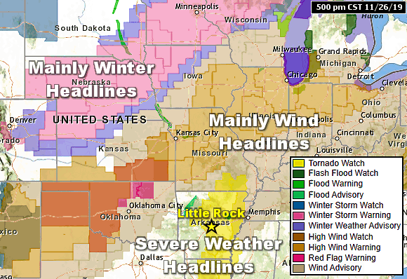
| In the picture: There was a variety of weather headlines (winter, wind, and severe storms) across the middle of the country on 11/26/2019. |
|
| |
|
A complex weather pattern ended the year. There was heavy snow from the northern Plains to the upper Midwest in the final days of November. Accumulations from eight inches to more than a foot were common from the Dakotas to northern Wisconsin. A few locations were buried under at least two feet of powder. In December, there were at least three dozen reports of tornadoes from Louisiana into Mississippi and Alabama. One of these tornadoes (rated EF3) tracked 62 miles and cut through DeRidder, LA and Alexandria, LA. Extensive damage to homes and businesses resulted, and there was one fatality. At the former location, people were trapped inside mangled structures. At least seven people were injured at a group home hit by a tornado in Sumrall, MS. Two people were killed and four people were injured due to a tornado in Town Creek, AL.
|
|
|
| In the picture: Local Incident Meteorologist (IMET) Joe Goudsward, a Senior Forecaster with the National Weather Service in Little Rock (Pulaski County), was requested to assist with fire weather forecasting duties in Australia in December, 2019. |
|
| |
|
There is one other thing to mention and that's wildfires. Across the western United States, wildfire season typically runs from mid-May to mid-November. While wildfires were noted in 2019, it was relatively quiet when compared to recent years. In California, the largest fire (the Kincade Fire) burned almost 78,000 acres in October/early November. This was much smaller than the Ranch Fire of September, 2018 that torched 410,000 acres. It was a different story in Australia, where flames have consumed 16 million acres due to record heat and drought. This catastrophic situation claimed at least twenty lives, thousands of structures, and millions of animals.
|
|
|