|
| Storm Reports |
| Are you interested in what happened during a recent event? Check out the report below. |
|
|
 |
Arkansas Yearly Climate Summary (2019)/Pg1 |
 |
| |
|
| 2019 Statistics |
| Month |
Tornadoes |
Tornado Deaths |
Wind (Tstm and Non-Tstm) Deaths |
Flood/Flash Flood Deaths |
Lightning Deaths |
| Jan |
0 |
0 |
0 |
0 |
0 |
| Feb |
1 (1, EF1: 1) |
0 |
0 |
1 |
0 |
| Mar |
3 (EF1: 3) |
0 |
0 |
0 |
0 |
| Apr |
2 (EF1: 1, EF2: 1) |
0 |
0 |
0 |
0 |
| May |
19 (EF0: 11, EF1: 8) |
0 |
0 |
1 |
0 |
| Jun |
2 (EF0: 2) |
0 |
0 |
1 |
0 |
| Jul |
0 |
0 |
0 |
0 |
0 |
| Aug |
1 (EF0: 1) |
0 |
0 |
1 |
0 |
| Sep |
0 |
0 |
0 |
0 |
0 |
| Oct |
5 (EF0: 1, EF1: 3, EF2: 1) |
0 |
1 |
0 |
0 |
| Nov |
0 |
0 |
0 |
2 |
0 |
| Dec |
0 |
0 |
0 |
0 |
0 |
| Total |
33 |
0 |
1 |
4 |
0 |
| Note: The latest tornado (rated EF0) affected areas east of Wilson (Mississippi County) near the Mississippi River on October 21st. The strongest tornado (rated EF2/maximum winds around 120 mph) tracked just over 31 miles from near Siloam Springs to Beaver Lake east of Rogers (Benton County) on October 21st. This tornado had a width of 1.5 miles, which is second highest in Arkansas since 1950. The widest tornado (1.65 miles/rated EF2) hit Vilonia (Faulkner County) on April 25, 2011. |
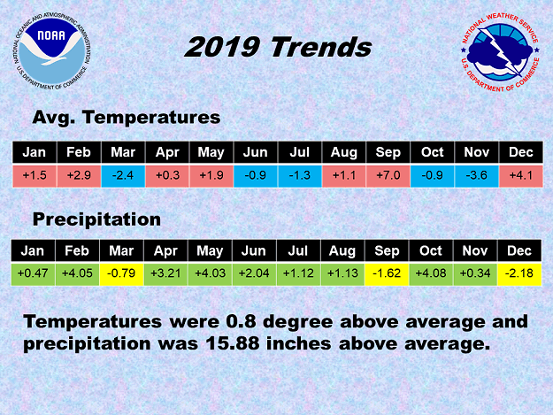 |
| In the picture: In 2019, above normal temperatures (in red) occurred in seven of twelve months, and above average precipitation (in green) was noted in nine months. Overall, it was a little warmer and a lot wetter than normal. |
|
| |
|
Looking statewide, temperatures and precipitation were largely above average. It was very wet through the first six months of the year (thirteen inches of liquid more than usual). In fact, it was a Top 5 wettest January through June dating back to 1895, and the wettest such time frame since 1990. It was not a hot summer overall, with prolonged heat and dryness waiting until September to appear. It was tied (with 1925) for the hottest September on record. Drought conditions developed in the southwest. Rain returned in October and November, and it turned colder. Freezes were early by a week or two in many areas. The year ended with mild conditions and not much falling from the sky in December. It was the driest month of 2019.
|
| 2019 Extremes |
| Type of Extreme |
Extreme Reached/Date of Extreme |
| Hottest Temperature |
106° at Crossett 2 SSE (Ashley Co.) - Sep 9 |
| Coldest Temperature |
2° at Kingston 2 S (Madison Co.) - Mar 5 |
| Most Rain (Year) |
85.75" at Portland (Ashley Co.) |
| Most Rain (Month) |
19.19" at Decatur 2.6 ESE (Benton Co.) - Oct |
| Most Rain (Day) |
16.17" at Dierks (Howard Co.) - Jul 16 |
| Least Rain (Year) |
49.57" at Omaha 2 S (Boone Co.) |
| Least Rain (Month) |
0.00" at Arkadelphia 2 N (Clark Co.) - Sep |
| Most Snow (Year) |
5.1" at Compton (Newton Co.) |
| Most Snow (Month) |
4.8" at Charleston 1.7 E (Franklin Co.) - Jan |
| Most Snow (Day) |
4.8" at Charleston 1.7 E (Franklin Co.) - Jan 20 |
| Highest Snow Depth |
5" at Charleston 1.7 E (Franklin Co.) - Jan 20 |
|
|
| |
|
Given a lot of rain early in the year, and extensive river flooding (including the historic Arkansas River flood), many fields were muddy or under water. It was far too wet for any planting during the beginning of the growing season. In August, The United States Department of Agriculture (USDA) released a report stating that Arkansas had 1.3 million unplanted (or prevented) acres. This was 5th highest in the nation. Eventually, 44 counties were declared primary natural disaster areas, and 24 neighboring counties were designated as contiguous disaster areas.
|
| Precipitation in 2019 |
| Site |
Amount |
Normal |
+/- |
% of Normal |
| Fayetteville (NW AR) |
65.26 |
48.51 |
+16.75 |
135% |
| Harrison (NC AR) |
56.98 |
44.14 |
+12.84 |
129% |
| Jonesboro (NE AR) |
65.89 |
48.10 |
+17.79 |
137% |
| Fort Smith (WC AR) |
67.50 |
45.46 |
+22.04 |
148% |
| Little Rock (C AR) |
60.46 |
49.75 |
+10.71 |
122% |
| West Memphis (EC AR) |
73.86 |
52.23 |
+20.63 |
141% |
| Texarkana (SW AR) |
51.53 |
49.65 |
+1.88 |
104% |
| El Dorado (SC AR) |
60.64 |
52.92 |
+7.72 |
115% |
| Pine Bluff (SE AR) |
63.96 |
51.15 |
+12.81 |
125% |
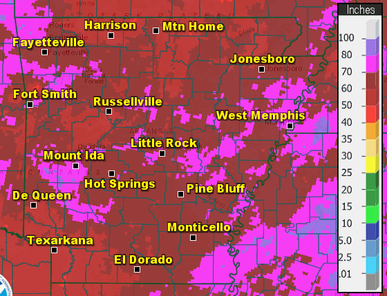
| Note: The statewide average precipitation was 65.49 inches, or 15.88 inches above average. This was the 7th wettest year on record. |
| Average Temperatures in 2019 |
| Site |
Avg Temp |
+/- |
| Fayetteville (NW AR) |
57.9° |
+0.9° |
| Harrison (NC AR) |
58.4° |
+0.5° |
| Jonesboro (NE AR) |
61.3° |
+1.3° |
| Fort Smith (WC AR) |
62.6° |
+0.9° |
| Little Rock (C AR) |
62.4° |
-0.3° |
| West Memphis (EC AR) |
63.1° |
+2.1° |
| Texarkana (SW AR) |
64.6° |
+0.7° |
| El Dorado (SC AR) |
64.4° |
+0.9° |
| Pine Bluff (SE AR) |
63.1° |
+0.2° |
| Note: The statewide average temperature was 61.2 degrees, or 0.8 degree above average. This was the 32nd warmest year on record. |
| |
| Now it's time to check out significant events in 2019 across Arkansas. To check out the rest of the story, click here. |
|
|