|
| Storm Reports |
| Are you interested in what happened during a recent event? Check out the report below. |
|
|
 |
Arkansas Yearly Climate Summary (2016)/Pg1 |
 |
| |
|
| 2016 Statistics |
| Month |
Tornadoes |
Tornado Deaths |
Wind (Tstm and Non-Tstm) Deaths |
Flood/Flash Flood Deaths |
Lightning Deaths |
| Jan |
0 |
0 |
0 |
1 |
0 |
| Feb |
0 |
0 |
0 |
0 |
0 |
| Mar |
13 (EF0: 6, EF1: 6, EF2: 1) |
0 |
0 |
0 |
0 |
| Apr |
9 (EF0: 2, EF1: 7) |
0 |
0 |
0 |
0 |
| May |
1 (EF1: 1) |
0 |
0 |
0 |
0 |
| Jun |
0 |
0 |
0 |
1 |
0 |
| Jul |
0 |
0 |
0 |
0 |
0 |
| Aug |
0 |
0 |
0 |
0 |
0 |
| Sep |
0 |
0 |
0 |
0 |
0 |
| Oct |
0 |
0 |
0 |
0 |
0 |
| Nov |
0 |
0 |
0 |
0 |
0 |
| Dec |
1 (EF1: 1) |
0 |
0 |
0 |
0 |
| Total |
24 |
0 |
0 |
2 |
0 |
| Note: The latest tornado (rated EF1) was spawned about 5 miles northeast of Grapevine (Grant County) on December 17th. The strongest tornado (rated EF2) happened on March 23rd at Evansville (Washington County), and was responsible for four injuries. |
|
|
| |
|
Precipitation totals ranged from around 25 inches in far northwest Arkansas to just over 70 inches in the far southeast. Temperatures for the year were on the warm side by one-and-a-half to two-and-a-half degrees.
|
| Precipitation in 2016 |
| Site |
Amount |
Normal |
+/- |
% of Normal |
| Fayetteville (NW AR) |
33.37 |
48.51 |
-15.14 |
69% |
| Harrison (NC AR) |
35.41 |
44.14 |
-8.73 |
80% |
| Jonesboro (NE AR) |
52.56 |
48.10 |
+4.46 |
109% |
| Fort Smith (WC AR) |
31.18 |
45.46 |
-14.28 |
69% |
| Little Rock (C AR) |
56.12 |
49.75 |
+6.37 |
113% |
| West Memphis (EC AR) |
53.02 |
52.23 |
+0.79 |
102% |
| Texarkana (SW AR) |
49.33 |
49.65 |
-0.32 |
99% |
| El Dorado (SC AR) |
61.64 |
52.92 |
+8.72 |
116% |
| Pine Bluff (SE AR) |
54.38 |
51.15 |
+3.23 |
106% |
| Note: The statewide average precipitation was 50.44 inches, or 0.83 inch above average. This was the 51st wettest year on record. |
| Average Temperatures in 2016 |
| Site |
Avg Temp |
+/- |
| Fayetteville (NW AR) |
58.8° |
+1.8° |
| Harrison (NC AR) |
60.1° |
+2.2° |
| Jonesboro (NE AR) |
62.6° |
+2.6° |
| Fort Smith (WC AR) |
64.3° |
+2.6° |
| Little Rock (C AR) |
65.2° |
+2.5° |
| West Memphis (EC AR) |
63.1° |
+2.1° |
| Texarkana (SW AR) |
66.4° |
+2.5° |
| El Dorado (SC AR) |
65.5° |
+2.0° |
| Pine Bluff (SE AR) |
64.5° |
+1.6° |
| Note: The statewide average temperature was 62.8 degrees, or 2.4 degrees above average. This was the 5th warmest year on record. |
 |
| |
 |
|
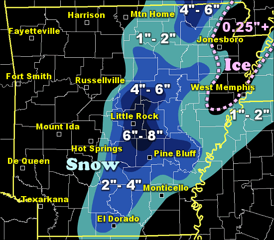
In the picture: Snow and ice totals in the twelve hour period ending at 600 am CST on 01/22/2016.
|
|
| |
|
The year started with a Top 5 mild winter (temperatures roughly four degrees above average), and not much snow. However, there was a memorable event on January 21st/22nd.
Snow piled up in a fairly narrow swath from El Dorado (Union County) to Pocahontas (Randolph County). This is along the U.S. Highway 67/167 corridors. Two to six inch accumulations were common. Ice accruals of a quarter of an inch or more occurred from Jonesboro (Craighead County) to Paragould (Greene County) and Piggott (Clay County). Snow and ice combined with 30 to 40 mph gusts to knock out power to at least 15,000 households in eastern Arkansas.
Snow was heaviest from Little Rock (Pulaski County) to Cabot (Lonoke). Six to eight inches of powder was measured in these areas. Typically, these locations get three to five inches of snow in an entire season.
At North Little Rock, 7.2 inches of snow was tallied, with 0.3 inch on the 21st and 6.9 inches on the 22nd. The 6.9 inches was the third highest calendar day snow of all time at the site behind January 6, 1988 (10.5 inches) and the Christmas Day episode of 2012 (8.6 inches).
|
| On February 23rd/24th, it was cold enough to support snow in the higher terrain of the Ozark and Ouachita Mountains (of the north and west). There was a lot of powder at elevations above 2000 feet. Kingston (Madison County) racked up 8 inches of accumulation. Eleven miles south of Jasper (Newton County), 8 to 9 inches fell. Similar amounts were reported at Mount Magazine State Park (Logan County) and at Queen Wilhemina State Park (Polk County). |
| Interestingly, while it was snowing around here, a tornado outbreak was unfolding to the south/east. At least five dozen tornadoes wreaked havoc in ten states. |
| Tornado Outbreak in February |
|
At least sixty tornadoes were spawned on February 23rd/24th, with most of these from southeast Louisiana and southern Mississippi to North Carolina and Virginia. Four of the tornadoes were rated at least EF3. The outbreak included a somewhat rare tornado (rated EF2) in White Horse, PA. This was the second largest February tornado outbreak since 1950. The outbreak was responsible for seven fatalities.
|
|
|
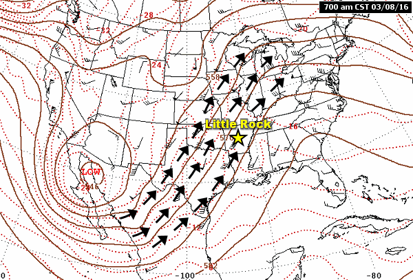
| 700 am CST (03/08) | 700 am CST (03/09) | 700 am CST (03/10) |
| In the pictures: A storm system ("Low") wobbled toward Arkansas from the southwest in the forty eight hour period ending at 700 am CST on 03/10/2016. High pressure ("High") over the southeast United States slowed the eastward progression of the system. Between these two features, a southerly flow pumped abundant moisture into the region from the Gulf of America. |
|
| |
|
As spring arrived, there was way too much rain in March. Ten to more than fifteen inches of liquid dumped in the southeast half of Arkansas. It was the third wettest March on record. The most rain (22.71 inches) occurred at Portland (Ashley County). At Little Rock (Pulaski County), the monthly total was 12.31 inches, shattering the old record of 10.43 inches in March, 1897!
A large chunk of the rain arrived as the second week began. A storm system inched toward the region from the southwest, and pumped tons of moisture northward from the Gulf of America.
|
|
|
| |
|
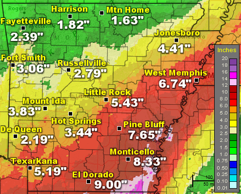
Seventy two hour (three day) rainfall through 600 pm CST on the 10th was over five inches in much of the south/east. At El Dorado (Union County), 9.00 inches of liquid was measured, with 8.33 inches at Monticello (Drew County), 7.65 inches at Pine Bluff (Jefferson County), 6.74 inches at West Memphis (Crittenden County), and 5.43 inches at Little Rock (Pulaski County).
Given this much rain, numerous roads were under water, closed and barricaded. Several state highways were impassible and shut down. High water threatened homes and businesses. At least twenty homes were damaged by flood water at McGehee (Desha County).
Rivers responded by going up, but the situation did not get out of hand. There was minor flooding at some forecast sites, but it could have been much worse. Before the rain came, water levels were down following a dry January/February. This left plenty of room for runoff.
|
| Flooding in Northern Louisiana/Eastern Texas |
|
From March 8th through the 11th, a whopping 20.66 inches of rain was tallied at Monroe, LA. This made March the wettest month on record, eclipsing the 20.56 inches that fell in October, 2009. Several rivers/bayous across the state achieved record crests, some by a few feet. Numerous evacuations were ordered to get people away from rising water. In east Texas, the Sabine River reached unprecedented levels. Flooding was so bad in Deweyville, TX that the town was "unrecognizable" to one media source.
|
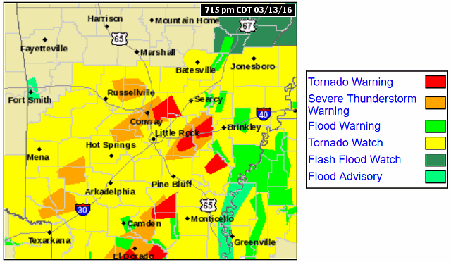 |
| In the picture: Numerous Severe Thunderstorm and Tornado Warnings were in effect at 715 pm CDT on 03/13/2016. Central and southern Arkansas were under a Tornado Watch. |
|
| |
|
Following the flooding, a fast moving storm system from the southern Plains promised a round of severe storms on March 13th. Nearly sixty Tornado and Severe Thunderstorm Warnings were issued by the National Weather Service.
|
 |
| 610 pm CDT (03/13) | 615 pm CDT (03/13) | 621 pm CDT (03/13) |
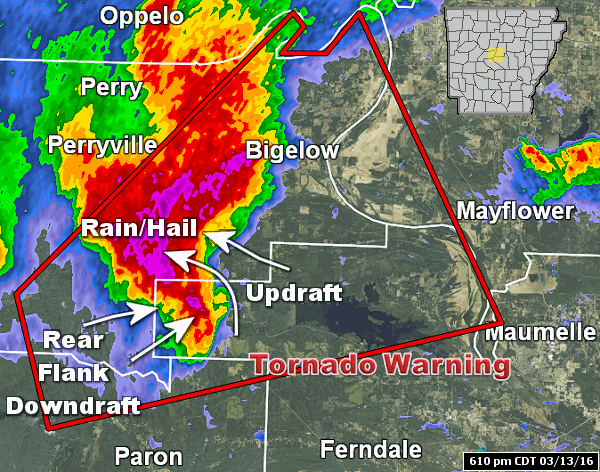
| In the pictures: The WSR-88D (Doppler Weather Radar) showed downdrafts to the rear of a severe storm wrapping around the updraft portion of the storm (which feeds warm/moist air aloft into the cloud for precipitation making) during the evening of 03/13/2016. The wrapping caused updrafts to coil (rotate) tightly, and a tornado (rated EF0) eventually resulted near Wye (Perry/Pulaski County). Many storms during the event had similar structure. |
|
| |
|
Given that it was cold overhead, ice/hail formed readily in many of the storms. Also, winds changed direction with height, and caused a turning motion/rotation in the storms.
Reports received during this event were impressive. Baseball size hail was produced at Mount Ida (Montgomery County), with ping pong to tennis ball size hail at Malvern (Hot Spring County), Jessieville (Garland County), Conway (Faulkner County), Bauxite (Saline County), and Sherwood (Pulaski County).
There was also at least ten small (rated EF0/EF1) tornadoes spawned across Arkansas, with seven of these in the Little Rock County Warning Area. These were the first tornadoes of 2016 locally, and the largest tornado event of the year.
Tornadoes downed or snapped a lot of trees, but there was little structural damage reported. Perhaps the most extensive damage was near Joplin (Montgomery County). At that location, boat docks were torn apart on Lake Ouachita. No injuries were reported.
|
| The Strongest Tornado of 2016 in Arkansas |
|
On March 23rd, a tornado (rated EF2) that started in Adair County, OK tracked 11 miles through Natural Dam (Crawford County) and Evansville (Washington County). This is in the Tulsa County Warning Area. Along the way, several mobile homes and outbuildings were destroyed, a couple of homes were severely damaged, and numerous trees were snapped or uprooted. Four people were injured.
|
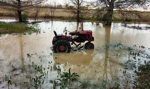 |
| In the picture: After rain ended, a tractor sat in a flooded yard near Tyronza (Poinsett County) on 04/01/2016. |
|
| |
|
The month ended with another swath of heavy rain from central into northeast Arkansas. Four plus inches of water was measured from Little Rock (Pulaski County) and Pine Bluff (Jefferson County) to Jonesboro (Craighead County).
|
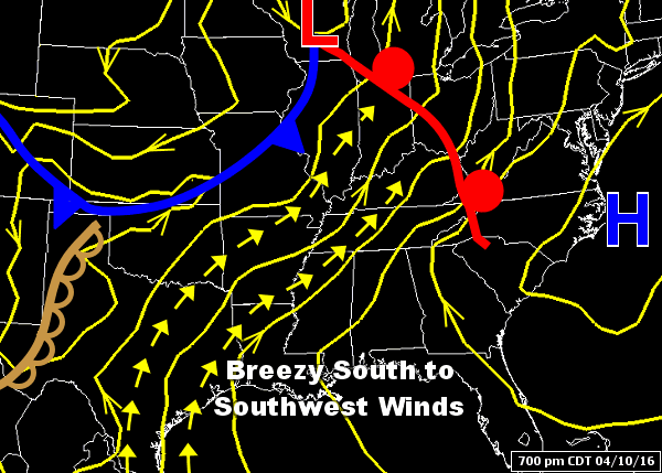 |
| In the picture: The pattern at 700 pm CDT on 04/10/2016, with gusty southerly winds kicking up between high pressure ("H") to the east and an approaching cold front in the Plains. |
|
| |
|
There was not much rain to begin April. On the 10th, it was mild, dry, and windy. Temperatures climbed into the 70s to lower 80s in much of Arkansas. In northeast sections of the state, south/southwest winds gusted to 40 mph at times, and relative humidity levels dropped below 30 percent. Topsoil from plowed fields was blown around, creating visibilities below a half mile in places.
Vehicles collided at Walnut Ridge (Lawrence County), and this resulted in one fatality and at least a dozen injuries. Highway 63 was closed due to dangerous driving conditions. A rare Dust Storm Warning was issued by the National Weather Service in Memphis, TN.
|
| Conditions at Newport (Jackson County) on 04/10/2016 |
| Time |
Wind (mph) |
Visibility (Miles) |
| 1056 am CDT |
SW31G41 |
1.00 |
| 1108 am CDT |
S31G37 |
0.50 |
| 1126 am CDT |
SW29G38 |
1.00 |
| 1135 am CDT |
SW29G37 |
0.75 |
| 1145 am CDT |
S32G37 |
0.50 |
| 1156 am CDT |
S31G36 |
1.00 |
| 1208 pm CDT |
S26G37 |
0.75 |
| Note: Relative humidity levels dropped below 30 percent (very dry) in the afternoon. |
|
|
| |
|
Rain started picking up in the middle of the month, but the fireworks really got going to close out April. Thunderstorms swept into Arkansas during the early morning hours of the 27th, and spawned half a dozen weak tornadoes in the far northwest. This was confirmed by the National Weather Service in Tulsa, OK.
The tornadoes (rated EF0/EF1) affected locations around Decatur (Benton County), Centerton (Benton County), Kibler (Crawford County), Wesley (Madison County), Charleston (Franklin County), and Ozark (Franklin County).
|
 |
| In the picture: Damaging straight-line winds downed trees on houses at Camden (Ouachita County) on 04/30/2016. |
|
| |
|
On the 29th/30th, severe storms removed part of a roof from a home north of Greenbrier (Faulkner County). Golf ball to baseball size hail pelted Alma (Crawford County) and Fort Smith (Sebastian County). The hail busted windows in vehicles. Trees were pushed over on houses on the northwest side of Camden (Ouachita County).
|
|
There were two more brief weak (rated EF1) tornadoes in the southwest (Columbia and Lafayette Counties). Mainly tree damage (uprooted or snapped) resulted.
Five plus inches of rain dumped from De Queen (Sevier County) to Hot Springs (Garland County), Little Rock (Pulaski County) and Augusta (Woodruff County). By the time April was over, rainfall was at least double the average in the southwest. This included El Dorado (Union County) and Texarkana (Miller County).
|
| Flooding in Eastern Texas |
|
On the west side of Houston, TX, over 15 inches of rain dumped in mid-April. Rapid rises were observed on Cypress Creek at Cypress, TX, which came within .08 feet (roughly an inch) of the highest mark (127.6 feet) reached in October, 1994. The creek flows through the north side of Houston, and flooded nearby subdivisions. Hundreds of people were rescued from the high water, and at least seven people were killed.
|
 |
| Plane Tossed at Salem (Fulton County) | Satellite/Temperatures at 500 pm CDT (05/09) |
| In the pictures: At Salem (Fulton County), damaging straight-line winds tossed small planes at the local airport on 05/09/2016. The storms that caused the damage were ahead of a dry line in Oklahoma. On the satellite image, temperatures (dashed yellow lines) were in the 80s west of the dry line, with lots of clouds and mild/moist air to the east. Scattered severe storms popped up along the dry line. |
|
| |
|
While there was plenty of severe weather and numerous tornadoes across the Plains in May, it was not so turbulent locally. Even so, there were some highlights to remember.
|
| Tornadoes in Oklahoma |
|
Storms quickly became tornadic east of a dry line in eastern Oklahoma on May 9th. Three massive tornadoes (rated EF3/EF4) ripped through the countryside 60 to 90 miles south/southeast of Oklahoma City, OK (including the towns of Katie, Wynnewood, Sulphur, Connerville, and Bromide). This resulted in a couple of fatalities.
|
|
Between 700 pm and 800 pm CDT on the 9th, a line of storms accelerated and bowed out toward the Missouri border. The bowing was caused by straight-line winds close to 90 mph racing to the east. On the southwest side of Salem (Fulton County), small planes were tossed at the airport. A steeple was removed from a church and a scoreboard was taken to the ground at a ball field. Trees were pushed over or snapped.
Just after 1030 pm CDT, a brief tornado (rated EF1) affected areas near Avilla (Saline County). Trees were uprooted, with some trees on houses. This was the 24th tornado of the year in the state, and the only confirmed tornado in May.
|
|
|
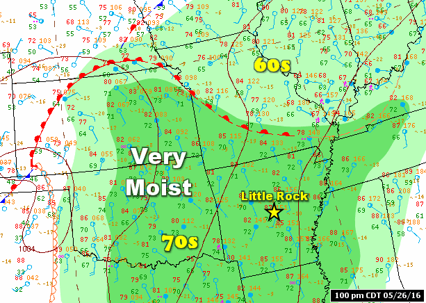
| In the picture: It felt like the tropics on 05/26/2016, with dewpoints in the 70s. |
|
| |
|
During the last week of the month, a persistent southerly wind ushered in very moist air (dewpoints in the 70s). This made thunderstorms more efficient rainmakers. At the cooperative observer site near Jonesboro (Craighead County), 6.52 inches of rain was measured in the twenty four hour period ending at 700 am CDT on the 25th. This broke an all-time record for the most precipitation in a day, surpassing the 5.57 inches that fell on September 1st, 1922. Flash flooding was widespread in the city. A child was swept into a storm drain and injured, but was rescued.
On the 29th, the high temperature was 92 degrees at Little Rock (Pulaski County). This was the first time the mercury touched 90 degrees locally in 2016.
|
| More Flooding in Eastern Texas/Tornadoes in Kansas |
|
More than a foot of rain dumped in places between Austin, TX and Houston, TX in late May. Roughly 65 miles northwest of Houston, 16.67 inches of rain was collected on the 26th in the town of Brenham. The one day record before the deluge was 10.38 inches on October 17th, 1994. In nearby Montgomery County (including the towns of Montgomery and Conroe), there was widespread flooding and hundreds of water rescues. Near record water levels were experienced on parts of the Brazos River. Closer to Austin, over 100 homes were damaged by high water at Bastrop. The flooding in Texas killed at least a dozen residents.
While the water was rising in Texas, folks in Kansas had to deal with tornadoes. Three tornadoes (rated EF2/EF3) damaged or destroyed homes on the north and west sides of Dodge City, KS. A long track (26 miles) tornado (rated EF4) paralleled Interstate 70 from Niles to Chapman.
|
| |
| There is more concerning the year 2016 in Arkansas. To check out the rest of the story, click here. |
|
|