After a winter that was the sixth warmest on record in Wilmington and ninth warmest in Florence, the NWS Climate Prediction Center is forecasting increased chances for below normal temperatures through March, followed by an increased chance for above normal temperatures later this spring. Seasonal rainfall totals are forecast to have roughly equal chances to fall into the below, near, or above normal ranges this spring.
|
CPC's temperature outlook shows an increased potential below-normal temperatures persisting through the end of March, followed by above-normal temperatures for the remainder of the spring. |
CPC Spring 2023 precipitation outlook shows equal chances for below, near, or above normal precipitation |
El Niño and La Niña have significant impacts on weather conditions across the United States and are also predictable at seasonal timescales. The La Niña pattern we experienced during the winter has ended and has been replaced by neutral conditions this spring as ocean water temperatures across the tropical east Pacific Ocean have rebounded to normal.
An upper level trough developed across the eastern United States on March 8, bringing temperatures considerably cooler than had been experienced throughout February and early March. Long range weather models indicate this trough should remain across the eastern United States through most of this month, favoring below normal temperatures. Beyond the range of these weather models we usually look at El Niño or La Niña to help guide seasonal forecasts -- but with a neutral ENSO pattern now in place the increased chance for above normal temperatures predicted later this spring is mainly the result of ongoing climate change.
|
Additional information on the current state of the Pacific Ocean and ENSO is available at https://www.cpc.ncep.noaa.gov/products/precip/CWlink/MJO/enso.shtml |
Observed trend in Spring average temperatures over the past 100 years across the eastern Carolinas climate zone. There is substantial year-to-year variability in observed temperatures but trends since the 1960s have been upward. |
Over the past 40 years there have been five times when La Niña ended during the late winter and and was replaced by neutral ENSO conditions for the spring: 1984, 1996, 2001, 2006, and 2009. Unfortunately none of those years experienced warm temperatures or persistent upper level ridging across the eastern United States like we experienced this past winter. This vast difference in the observed overall weather pattern reduces the value of those previous years as analogs to what we may experience this spring.
Spring Freeze
Consistently above average temperatures through January into early March caused plants to bloom and leaf out ahead of their normal schedule. A tally of Growing Degree Days, a measure of how favorable temperatures have been for promoting plant growth, showed well above normal values in early March. This means trees, bushes, and grasses have likely experienced advanced levels of growth for this early in the year. Even if the last freeze were to occur near the climatological date this spring, there still would be agricultural impacts. A later than normal freeze would cause even more significant impacts.
|
Growing Degree Days (GDD) for Wilmington, NC and Florence, SC through March 7. Well above normal values have been recorded, indicating a rapid rate of plant growth for this early in the year. Graphics courtesy of IEM. |
The average date of the last spring freeze varies from March 13 in Georgetown, SC to April 4 in Lumberton, NC, but there is significant variability from year to year based on weather conditions. Click below for an historic review of spring freeze dates for various sites across the eastern Carolinas.
|
|
|
Rainfall and Drought
Spring is typically one of the drier times of the year across the eastern Carolinas with monthly average rainfall totals less than 3 inches for many locations. This is because the jet stream lifts northward during the spring bringing fewer wet storm systems our way, but humidity usually hasn't increased enough to support widespread afternoon thunderstorms like during the summer.
With La Niña now gone and ENSO-neutral conditions favored to continue through spring, there aren't any reliable climate signals favoring consistently above or below normal rainfall.
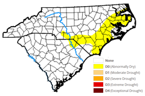
Drought conditions improved significantly over the winter and only a portion of eastern North Carolina is still classified as "abnormally dry," the lowest classification of drought used in the U.S. Drought Monitor. Given current conditions and predicted precipitation this spring, the Climate Prediction Center is showing potential for drought to redevelop across portions of coastal South Carolina.
|
U.S. Drought Monitor as of March 9, 2023 |
The Seasonal Drought Outlook from CPC shows development of drought conditions is likely this spring along a portion of the South Carolina coast |
Spring usually sees a shift in the character of rainfall as the season progresses. Periodic winter-like rains in early spring become less common in April and May, replaced by shorter and heavier showers and thunderstorms. The potential for severe thunderstorms also increases throughout the spring, driven by warming temperatures from longer days and higher sun angles. Hail and non-tropical tornadoes are more common during the spring than at any other time of the year across the eastern Carolinas.
|
Summary of severe weather occurrence across the area served by NWS Wilmington, NC. (click graphic for a larger version) Hail and non-tropical tornadoes are more common during the spring than at any other time of the year. Severe thunderstorms with damaging winds become more common during April and May, but peak in occurrence during the summer months. |
Wildfire Risk
Forecasters with the National Interagency Fire Center (NIFC) monitor trends in drought, fuel moisture, and plant growth to create maps highlighting the hazards posed by wildfire. Their outlook shows a near normal wildfire risk for this spring season. Spring is still the peak time for wildfires across eastern North and South Carolina. Strong sunshine, relatively low rainfall totals, and frequent cold fronts followed by dry winds can set the stage for conditions that can favor the rapid spread of wildfire.
Avoid outdoor burning on days when low humidity and gusty winds coexist. Check our latest Fire Weather Forecast to see if conditions will allow safe burning.
|
National Interagency Fire Center (NIFC) outlooks this spring for wildland fire potential |
Coastal Flooding
Full moons will occur this spring on March 7, April 6, and May 5. New moons occur on March 21, April 20, and May 19. Fortunately, no periods of unusually high tides are expected to occur solely due to astronomical tides. Any period of strong onshore winds or nearby significant low pressure could still result in minor coastal flooding this spring, but the risk appears lower than usual.
 |
For astronomical tide predictions, please see the NOAA Tides and Currents page. For local Total Water Forecasts that incorporate the effects of weather and wind on coastal water levels, check our local AHPS pages for Wrightsville Beach, Myrtle Beach, and the Cape Fear River at Downtown Wilmington.
Additional Information
Page Updated: March 10, 2023
Research and Page Author: Tim Armstrong


 Recent ocean temperature anomalies across the Pacific Ocean show the area of unusually cold water (blue colors) associated with this winter's La Niña is fading away. ENSO-neutral conditions should continue this spring.


 Coastal Flood