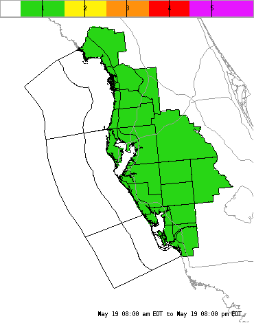
| Today's Weather Impact Levels (click on specific hazard for details) |
| Lightning |
Tornado |
Wind |
Hail |
Inland
Flood |
Coastal
Flood |
Rip
Current |
Waves |
Visibility |
Heat/Cold |
 |
 |
 |
 |
 |
 |
 |
 |
 |
 |
 |
 |
 |
 |
 |
 |
 |
 |
 |
 |
| |
| Inland Flood Hazard |
|
|
| Legend (Click for Impacts) |
| None |
No flooding |
| Low |
Ponding of water in poorly drained locations possible. |
| Moderate |
Flooding, entering structures or vehicles possible. |
| High |
Widespread flooding, having major impact on structures along with possible road closures. |
| Extreme |
Catastrophic: Life at risk; neighborhoods inundated; numerous road closures. |
|
|
 |
|
| Inland Flood Impact Statement |
| For additional hazard information, view the full Hazardous Weather Outlook text. |
| |
| Inland Flood Impact Definitions |
| Inland Flood Impact: None |
| No Flooding. |
| Inland Flood Impact: Low |
Residents can expect nuisance flooding of roads with poor drainage. Ponding will occur elsewhere. Known intersections with very poor drainage may have water levels up to 2 feet. Other poor drainage areas will have water rises up to 1 foot.
Urban Flood Advisories may be needed. |
| Inland Flood Impact: Moderate |
Residents can expect widespread flooding, especially in poor drainage locastions. In these areas, minor to moderate property damage is expected, and several main thoroughfares may be closed. Known intersections with very poor drainage may have water levels up to 4 or 5 feet. Other poor drainage areas will have water rises up to 3 feet. Levels will rise up to 1 foot elsewhere.
Most small streams and creeks will reach or exceed bank full. Larger rivers will rise. Those which respond quickly to very heavy rain may briefly exceed flood stage. |
| Inland Flood Impact: High |
Widespread Dangerous Flooding Possible
Persons living near or in poor drainage locations should prepare for possible evacuation later tonight. In these areas, significant property damage will occur, and some power outages are likely. Minor property damage is possible elsewhere.
Water levels in very poor drainage areas will approach 7 feet. Other poor drainage locations will have rises to between 3 and 5 feet. Elsewhere, expect water rises to near 2 feet. Numerous main roads will be closed. Driving is highly discouraged except in emergencies.
All rivers in affected areas will rise, with some reaching or exceeding flood stage. Normally quick rising rivers will exceed flood stage by several feet, flooding homes along the shore. Pastures will also flood, but livestock losses should be minimal. Several secondary roads and bridges will be washed out. |
| Inland Flood Impact: Extreme |
Widespread Catastrophic Flooding Possible!
Residents in flood prone areas should rush to completion preparations to protect their property, then move to a place of safety. Mandatory evacuations are underway in flood prone locations.
Life threatening flooding is likely. In urban areas, extensive property damage will occur in all poor drainage areas, with moderate to major property damage elsewhere. Widespread power outages are likely.
In rural locations, all small streams and creeks will surpass bank full for more than 6 hours. Each will exceed their banks by several feet, flooding homes - even those up to one half mile away from the banks. In all areas, hundreds of roads will flood. Dozens of secondary roads may become washed out in rural areas. Numerous bridges will likely wash out as well.
Water levels will exceed 5 feet in all poor drainage urban areas...and average at least 2 feet elsewhere. All rivers in affected areas will rise; most will exceed flood stage. Quick rising rivers will exceed flood stage - and reach near record crests, causing inundation of nearby homes. In rural locations, extensive pasture flooding will occur as water levels rise to 2 feet or more. Widespread livestock losses are likely. |
|