 |
| For Your Information |
| If there is something that may be of interest to you, we will try to make that information available. |
|
|
 |
Winter Outlook (December, 2023 to February, 2024) |
 |
| |
|
|
Temperature Outlook | Precipitation Outlook
Strong El Niño |
| In the pictures: Given a strong El Niño (warmer than normal water by at least 2.0°C along the equator in the Pacific Ocean), confidence is highest in a wetter than normal winter (December, 2023 through February, 2024) across much of the southern United States. Temperatures are more uncertain, but similar El Niños in the past yielded mostly above average readings in Arkansas. The graphics are courtesy of the Climate Prediction Center and the International Research Institute for Climate and Society/Columbia University. |
|
| |
|
One of the most reliable long-range predictors deals with monitoring water temperatures along the equator in the Pacific Ocean. If the water cools, we trend toward La Niña. If warming occurs, then it's El Niño. Both variables have a say in how the weather behaves across the country, especially when they become dominant. In the coming months, the pendulum will swing strongly toward El Niño, which favors warmer and drier conditions across the northern states, and a wetter scenario farther south this winter. Confidence in temperatures across the south are more uncertain.
|
| What It Means For Arkansas |
|
Confidence is swayed toward above average temperatures this winter locally. That does not mean it will be mild the entire three month period (December through February). Instead, it is implied that rounds of cold air will be fewer than in a typical winter.
The same rationale applies to the precipitation outlook. The forecast is leaning toward a wetter than normal winter, especially in southern sections of the state. While there will be dry periods, big slugs of moisture should be more than usual (and chances of wintry precipitation if cold air is in place). As a side note, the degree of wetness will dictate how an ongoing drought improves or worsens moving forward. This will be evaluated more closely as winter progresses.
|
|
Across Arkansas, precipitation was above to well above average during most moderate to strong El Niños going back forty years (into the early 1980s). Statewide amounts were on the plus side of normal in four out of five winters, and there was a surplus of liquid by more than two inches in three of those winters.
|
| Precipitation in Arkansas (December through February) |
| El Niño Years |
Precipitation |
+/- |
| 2015/2016 |
12.89" |
+0.77" |
| 2009/2010 |
14.22" |
+2.10" |
| 1997/1998 |
15.17" |
+3.05" |
| 1991/1992 |
11.86" |
-0.26" |
| 1982/1983 |
16.97" |
+4.85" |
|
Temperatures were largely warmer than usual. Readings were more than two degrees above average in three of five winters. The outlier was the winter of 2009/2010, which was colder than normal by over four degrees! That's because El Niño was overwhelmed by the effects of a long term negative Arctic Oscillation (AO).
|
| Temperatures in Arkansas (December through February) |
| El Niño Years |
Avg Temp |
+/- |
| 2015/2016 |
45.5° |
+4.2° |
| 2009/2010 |
37.0° |
-4.3° |
| 1997/1998 |
43.7° |
+2.4° |
| 1991/1992 |
44.8° |
+3.5° |
| 1982/1983 |
42.8° |
+1.5° |
|
In the strongly negative phase of the AO, pressure is higher toward the North Pole, and this sets up a blocking pattern. Cold air traversing Canada is forced to the south, and our temperatures drop.
|
 |
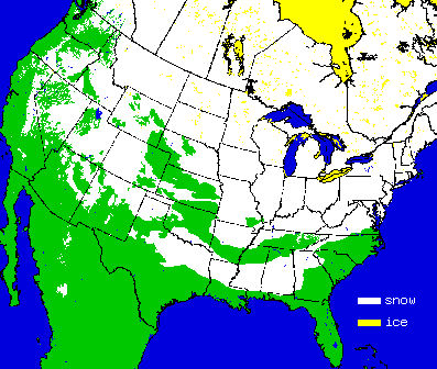
In the winter of 2009/2010, there was a long term negative AO, and that led to one cold blast after another. In early February, a powerful storm brought as much as three feet of snow to the mid-Atlantic region (called "Snowmageddon"). By the 12th, there was at least some snow on the ground in 49 states (including Arkansas). |
| In the picture: Snow cover on 02/12/2010. The graphic is courtesy of the National Centers for Environmental Information (NCEI) in Asheville, NC. |
| Long Term Strongly Negative AO Occurrences |
|
Since 2000, the AO dropped below -1.5 (strongly negative) for two or more consecutive months only five times. Two of these instances were less than a year apart (December, 2009 to February, 2010 and December, 2010/January, 2011). The next time it happened was ten years later (December, 2020/January, 2021).
|
 |
| In the picture: Tornadoes in Arkansas (2000 to 2022). Of the 891 tornadoes spawned in this twenty three year period, 339 tornadoes (38%) occurred in the fall/winter (September through February). |
|
| |
|
One other thing to mention is severe weather. Although most people associate the spring months with severe storms, Arkansas is no stranger to tornadoes in the fall and winter. In fact, almost four of ten tornadoes from 2000 to 2022 occurred between September and February.
|
|
|