|
| Storm Reports |
| Are you interested in what happened during a recent event? Check out the report below. |
|
|
 |
Wintry Precipitation on November 11-18, 2022 |
 |
| |
|
|
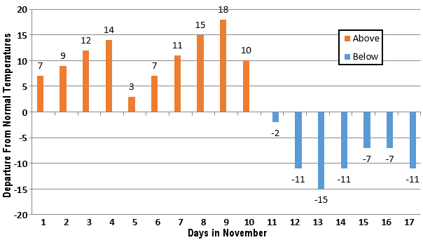
| In the picture: After ten straight days of above normal temperatures at Little Rock (Pulaski County) to begin November, 2022, readings were cooler than usual in the seven days to follow. |
|
| |
|
November began with mild conditions in Arkansas, and a tornado outbreak on the 4th (16 tornadoes). That changed in a hurry, with below average temperatures from the 11th through the 17th, and three snow events in northern and western sections of the state.
|
|
|
| In the video: This model showed snow developing across northern Arkansas during the evening of 11/11/2022. The data is courtesy of the college of DuPage. |
|
| |
|
Late on the 11th/early on the 12th, a storm system crossing the southern Plains spread light precipitation into the region, with most areas getting rain. Light snow developed across the northern counties during the evening, and there was some accumulation toward the Missouri border. Two to three inches of snow was reported at Mammoth Spring (Fulton County), with an inch near Flippin (Marion County), Mountain Home (Baxter County), and around Strickler (Washington County). A half inch of snow dusted the ground at Biggers (Randolph County) and Hoxie (Lawrence County).
|
 |
| In the picture: At 700 pm CST on 11/14/2022, snow was reported in parts of the Ozark and Ouachita Mountains in northern and western Arkansas. Elsewhere, it was a cold rain, with sleet at times in places. |
|
| |
|
It was a repeat performance late on the 14th/early on the 15th, but this time there was a little more snow. The snow was mainly across the Ozark and Ouachita Mountains in the north and west. The rest of Arkansas experienced a cold rain, but there were pockets of sleet in places.
|
 |
| In the picture: The higher elevations of the Ozark Mountains received two to more than three inches of snow during the evening of 11/14/2022. |
|
| |
|
Four to five inches of flakes piled up a few miles southwest of Hogeye (Washington County). Four inches of snow was tallied at Greenland, Strickler, and West Fork (all in Washington County).
|
|
|
| In the video: This is snow in slow motion at the country store in St. Paul (Madison County) during the evening of 11/14/2022. The video is courtesy of Charles Peek via Twitter. |
|
| |
|
Three to four inches of powder accumulated at Winslow (Washington County), with three inches at Compton (Newton County), southeast of Kingston (Madison County), southwest of Marshall (Searcy County), and northeast of Weathers (Madison County).
|
 |
| In the picture: Roads were snow or slush covered in northwest Arkansas early on 11/18/2022. The information is courtesy of IDriveArkansas. |
|
| |
|
A cold front arriving from the north brought one more round of snow mostly during the predawn hours of the 18th. There was very little moisture in place, so what fell from the sky was very light (generally a half inch or less). However, there was just enough snow to coat bridges/overpasses in the northwest, and create a lot of chaos.
|
|
|
| In the video: Bridges became icy and dangerous early on 11/18/2022, and this led to numerous accidents. The video is courtesy of Brian Emfinger via Twitter. |
|
| |
|
Numerous accidents were reported in portions of Benton and Washington Counties, mainly along Interstate 49. According to several sources, accidents started between 500 am and 600 am CST, and continued for a few hours. The highway was closed temporarily to treat icy bridges.
|
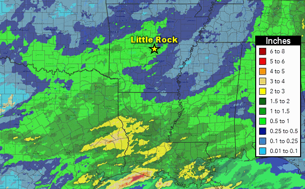 |
| In the picture: Seven day precipitation totals through 700 am CST on 11/18/2022. |
|
| |
|
Overall, precipitation amounts for the seven day period ending at 700 am CST on the 18th were not impressive. Most locations that got snow had less than a half inch of liquid equivalent. Farther south, rainfall was generally between a quarter and three quarters of an inch, with locally over an inch. The heaviest downpours were along the Gulf Coast. From parts of east Texas into Louisiana, one to three inch totals were common.
|
 |
| In the picture: The forecast called for at least three to four feet of snow at Buffalo, NY in a four day period ending at 100 pm EST on 11/20/2022. The forecast is courtesy of the National Weather Service in Buffalo, NY. |
|
| |
|
Our snow issues were nothing compared to what happened in western New York. A massive lake effect snow event yielded six to seven feet of snow at Orchard Park, NY (about ten miles southeast of Buffalo, NY) from the 16th through the 20th.
|
| Lake Effect Snow Buries Western New York |
|
A long west to east fetch of cold air blowing over warmer water in Lake Erie and Lake Ontario triggered a massive lake effect snow event in western New York in mid-November. As of the evening of the 20th, ninety six hour snow accumulations were up to 80 inches at Orchard Park, NY. This is where a National Football League game was scheduled on the 20th, and had to be moved to Detroit, MI. The ordeal was reminiscent of a similar episode eight years ago. In November, 2014, almost seven feet of snow was deposited on the east side of Buffalo, NY. Thirteen lives were lost.
|
|
|