Arkansas has had its share of historic events, many of which will be in our memories for years to come.
Two Heavy Snows/Arctic Cold on February 14-20, 2021
In the video: Arctic air and moisture came together to produce heavy snow across Arkansas on February 14-15, 2021. Frigid conditions were the result of a piece of the Polar Vortex (near the North Pole) breaking off and heading southward. Moisture was provided by a storm system riding an active Subtropical Jet across the southern United States.
The floodgates from the North Pole opened, and frigid conditions poured into Arkansas in mid-February. High temperatures in northern sections of the state were only in the single digits in places on the 14th. It was 9 degrees in Harrison (Boone County), for example. Across the remainder of the region, teens and 20s were common.
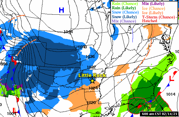
In the pictures: Forecast maps showed wintry precipitation spreading across Arkansas ahead of Arctic high pressure ("H") to the north in the forty eight hour period ending at 600 am CST on 02/16/2021. As one storm system exited to the east toward the end of the period, there was another system on the horizon to the west.
At the same time, the Subtropical Jet became active, and drove storm systems across the southern United States. One system arrived on the 14th, and produced mostly snow and sleet through the 15th.
In the picture: Winter weather headlines were posted for the deep south as of 315 pm CST on 02/14/2021.
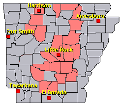
Winter Storm Warnings were in effect for all of Arkansas during the event. Even more alarming/impressive was the fact that Winter Storm Warnings covered all of Texas to the Rio Grande River! This very rare situation (wintry precipitation and cold) put stress on the power grid in the Lone Star State, knocking out electricity to more than four million homes.
This is our latest snow event as it got going around 630 am CST on Monday (February 15). It was captured by one of our employees driving home after a midnight shift through Sherwood (Pulaski County). pic.twitter.com/FjmEY99GIT
In the video: Snow started coming down heavily by 630 am CST on 02/15/2021 as captured by a National Weather Service employee driving through Sherwood (Pulaski County) after a midnight shift.
Snow really got going locally during the wee hours of the 15th. A large swath of snow to the southwest made its way into the area, and it came down at a rate of two inches per hour at times. This was a fluffy/powdery snow, so it accumulated quickly.
Snow was heaviest from southwest into central and northeast Arkansas, and piled up more than ten inches at some locales. Close to eleven inches of snow was measured at Greers Ferry (Cleburne County), the North Little Rock Airport (Pulaski County), Perryville (Perry County), and near Vilonia (Faulkner County). Eight to ten inch totals were reported at Cabot (Lonoke County), Daisy (Pike County), Fairfield Bay (Van Buren County), Greenbrier (Faulkner County), Hot Springs (Garland County), Little Rock and Maumelle (both in Pulaski County), Mountain Home (Baxter County), south of Mount Ida (Montgomery County), Paron (Saline County), and Pearcy (Garland County).
Little Rock (Pulaski County) had an event total of 8.4 inches. This ended a more than three year snow drought, with the last inch of snow on January 15, 2018.
In the picture: Subfreezing temperatures were noted all the way into south Texas as of 200 pm CST on 02/15/2021. Readings were below zero as far south as Kansas and Missouri.
It was even colder on the 15th. High temperatures were mostly in the single digits and teens. It was 4 degrees at Fayetteville (Washington County), Harrison (Boone County), and Highfill (Benton County), and 6 degrees at Mountain Home (Baxter County). At noon CST, given a north to northwest wind at 10 to 15 mph (and higher gusts), wind chill index readings ranged from zero to twenty below zero in northern and central sections, and a few degrees above zero in the south. While snow tapered off in the afternoon (there were leftover flurries), clouds hung around the bulk of the day.
There was clearing after dark, especially in the northwest. With snow cover, the mercury plummeted. The 16th started with well below zero readings in the northwest. It was -20 degrees at Fayetteville (Washington County)! Going back through records (using information from the experimental station on the north side of town), it was comparably cold on the morning of February 10, 2011. Otherwise, it had not been this much below zero since 1930. At Highfill (Benton County), it was -13 degrees, with -9 degrees at Harrison (Boone County) and Russellville (Pope County), and -8 degrees at De Queen (Sevier County) and Fort Smith (Sebastian County). Little Rock (Pulaski County) had -1 degree, which was the lowest reading since December 23, 1989.
In the picture: A Tornado Warning was in effect for locations roughly 35 miles southwest of Wilmington, NC until 1215 am EST on 02/16/2021. The warning information is courtesy of the National Weather Service in Wilmington, NC via Twitter.
This time of year, there is often severe weather (where it is mild) when snow/ice is ongoing (where it is cold). In this case, severe storms affected the Florida Gulf Coast to the mid-Atlantic states. One storm cranked out hurricane force winds (up to 80 mph) at Panama City Beach, FL during the afternoon of the 15th. Embedded in the swath of straight-line winds, a weak tornado (rated EF0/85 mph peak winds) was also confirmed. Roofs were blown off and fences were flattened. During the late evening, a strong tornado (rated EF3/160 mph peak winds) hit 35 miles southwest of Wilmington, NC (close to the Ocean Isle Beach, NC community). Dozens of homes were heavily damaged or destroyed. There were at least three fatalities.
The satellite shows storm #1 pulling away from Arkansas (to the northeast). Meanwhile, here comes storm #2 from the west. You guessed it...more snow.#arwxpic.twitter.com/Qo9yKBpZ4u
In the video: The satellite showed the snowstorm of February 14-15, 2021 moving away from Arkansas (to the northeast), with another system and the promise of more snow looming to the west.
Just as the chaos ended, there was much more to come. Storm system number two was a couple of days away, and it was plenty cold enough for additional heavy snow.
In the picture: Temperatures were more than thirty degrees below average at times from February 14-20, 2021 at Little Rock (Pulaski County).
Preceding the second system, temperatures were an almost surreal twenty to more than thirty degrees below average. The only hint of warmer air trying to sneak into the state was the far southeast, and this increased the threat of ice. Otherwise, it was mostly flakes. This was also scary because there was more moisture available than with the first system.
At 230 pm CST...This is not good. Interstate 40 (westbound) is backed up at Exit 202/Biscoe (Prairie Co), and vehicles are not moving at all. This is according to a @myARDOT traffic camera.#arwxpic.twitter.com/L2dJKvQIkd
In the video: A line of vehicles (mostly trucks) was parked along Interstate 40 heading west near Biscoe (Prairie County) during the afternoon of 02/17/2021. The video is courtesy of the Arkansas Department of Transportation via Twitter.
Snow spread across the north/west from the late evening of the 16th into the predawn hours of the 17th. For the remainder of the 17th, central/southern Arkansas got in on the action, and it went nuts from Little Rock (Pulaski County) southward.
From the afternoon of the 17th into the nighttime hours, there was way too much snow along Interstate 40 near Biscoe (Prairie County). Multiple accidents led to a line of traffic miles long in the westbound lanes that sat for sixteen hours. People were forced to spend the night on the road.
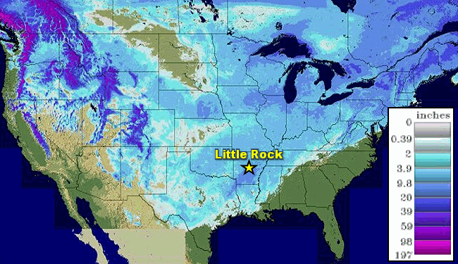
In the pictures: Estimated snowfall and liquid precipitation for the events (two of them) on February 14-18, 2021.
Incredibly, about fifteen inches of snow was unleashed near Sheridan (Grant County), with thirteen inches at Malvern (Hot Spring County) and Sulphur Springs (Jefferson County), and about a foot at Gurdon (Clark County), Hope (Hempstead County), and Prescott (Nevada County). Through social media, quite a few pictures were posted of tape measures and rulers penetrating through at least twenty inches of snow (the result of two storms) in yards across the south.
In the picture: Snow was on the ground all the way to the Gulf Coast at 600 am CST on 02/19/2021.
This time around, Little Rock (Pulaski County) was buried with 11.8 inches of snow. At least forty flights into the airport were cancelled on the 17th, and the facility closed during the evening.
In the pictures: Top ten snowiest lists (days, twenty four hours, years, months, and depth) at Little Rock (Pulaski County).
Historically, the 17th was the second snowiest day on record going back to the late 1800s (in the top spot was 12.0 inches on March 6, 1875). The February tally of 20.3 inches was more than any other month (topping 20.0 inches in January, 1918), and made 2021 the third snowiest year (a foot less than the 32.6 inch record in 1960). The snow depth on the morning of the 18th was 15 inches, which was tied for first place in the record book (with January 21, 1918).
In the video: Here are aerial views of a snow covered Little Rock (Pulaski County) on 02/18/2021. The video is courtesy of Charles Peek via Twitter.
There was enough water to worry about the weight of the snow stressing the roofs of some structures. On the 18th, part of the roof of a volunteer fire department caved in just northeast of Rison (Cleveland County). At Crossett (Ashley County), a bowling alley roof collapsed, and roofs were compromised at a packaging plant and a church. Some of this was attributed to a lot of sleet. Frozen pipes are a common concern in winter, and this became a huge problem in Mayflower (Faulkner County). Supply lines burst, and the city ran out of water. As a safeguard, many folks in central Arkansas were asked to conserve water as pipes thawed out and were subject to pressure breaks. Residents in cities such as Benton (Saline County), Hot Springs (Garland County), and Pine Bluff (Jefferson County) were urged to cut down on water usage due to a critically low supply. During the evening of the 18th, accidents along Interstate 30 led to tie ups between Benton (Saline County) and Malvern (Hot Spring County).
Big Time Water Shortage
Burst pipes and non-functioning water treatment plants (due to power outages) left nearly half of Texas (fourteen million people) without clean running water. Dry water taps in homes and a shortage of bottled water forced some people to boil snow for drinking or flushing toilets. In most major cities in the state, boil orders were in effect where water was available.
It was the same story for most folks in Jackson, MS. An aging infrastructure and brittle pipes were no match for well below freezing temperatures, snow, and ice. Water was not deemed safe and had to be boiled weeks after winter's wrath was over.
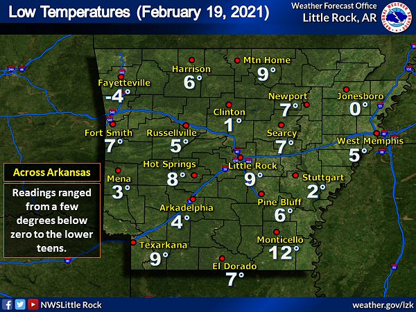
In the picture: Low temperatures on 02/19/2021. Readings ranged from a few degrees below zero to the lower teens.
Once system number two departed, the records kept on coming. On the morning of the 19th, many places had low temperatures in the single digits, which was well under normal lows in the upper 20s to upper 30s. Sure, these lows had been experienced in the past, but earlier in the winter. It was 2 degrees at Stuttgart (Arkansas County), 5 degrees at Russellville (Pope County), 6 degrees at Pine Bluff (Jefferson County), 7 degrees at El Dorado (Union County), and 9 degrees at Little Rock (Pulaski County) and Texarkana (Miller County). At these and other sites, data shows it had never been this cold so late in the year.
Record late lows were extended another day (on the 20th) as a deep snow pack continued to promote cooling. The thermometer showed 9 degrees at Little Rock (Pulaski County), 4 degrees at Pine Bluff (Jefferson County), and 4 degrees at Stuttgart (Arkansas County).
Here's one more eyebrow raiser. Just after 300 pm CST on the 19th at Little Rock (Pulaski County), the temperature hit 33 degrees after staying at or below freezing for a lengthy 210 consecutive hours (since 830 pm CST on the 10th). This string of bone chilling hours was the third longest (and short of the 308 hour record from December 18-31, 1983).
Storm Reports
There were numerous reports of mainly snow on February 14th/15th. For a look at the reports, click here.