 |
| For Your Information |
| If there is something that may be of interest to you, we will try to make that information available. |
|
|
 |
What is a Tornado Emergency? |
 |
| |
| Back in 1999, a destructive tornado (eventually rated F5) was bearing down on the Oklahoma City, OK area on May 3rd. Forecasters at the National Weather Service in Norman, OK had a Tornado Warning in effect, but felt that it was not enough. They needed to enhance the wording in the warning somehow to catch the attention of people in the path of this monster. That is when the Tornado Emergency was hatched. |
...TORNADO EMERGENCY IN SOUTH OKLAHOMA CITY METRO AREA...

AT 6:57 PM CDT...A LARGE TORNADO WAS MOVING ALONG INTERSTATE 44 WEST
OF NEWCASTLE. ON ITS PRESENT PATH...THIS LARGE DAMAGING TORNADO WILL
ENTER SOUTHWEST SECTIONS OF THE OKLAHOMA CITY METRO AREA BETWEEN
7:15 AND 7:30 PM. PERSONS IN MOORE AND SOUTH OKLAHOMA CITY SHOULD
TAKE IMMEDIATE TORNADO PRECAUTIONS!

THIS IS AN EXTREMELY DANGEROUS AND LIFE THREATENING SITUATION. IF
YOU ARE IN THE PATH OF THIS LARGE AND DESTRUCTIVE TORNADO...TAKE
COVER IMMEDIATELY.

DOPPLER RADAR HAS INDICATED THIS STORM MAY CONTAIN DESTRUCTIVE HAIL
TO THE SIZE OF BASEBALLS...OR LARGER.
|
 |
| Rotation | Debris Ball | More About Rotation |
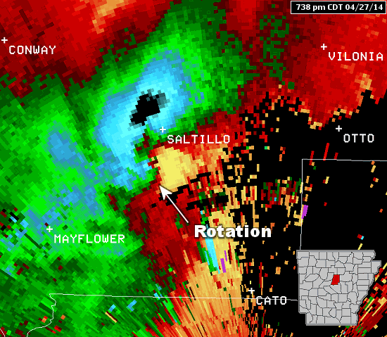
| In the pictures: The WSR-88D (Doppler Weather Radar) showed strong rotation between Mayflower and Vilonia (both in Faulkner County) at 738 pm CDT on 04/27/2014. There was also a debris ball present, which is a very good indicator of a tornado causing damage. |
|
| |
|
There was no guidance on how to write such a product. Forecasters did not follow any protocol. They just did it.
In 2007, the National Weather Service in Dodge City, KS was faced with a similar situation on May 4th. Tornado Emergencies were still unofficial and hardly ever used, but that did not stop one from going out to the people of Greensburg, KS (preceding an EF5 monster).
Fast forward to the Super Tuesday Tornado Outbreak of February 5, 2008, and a record (for that time) five Tornado Emergencies were disseminated in Tennessee and Alabama. There were none in Arkansas.
|
 |
That was the day a deadly tornado (rated EF4) cut a 122 mile swath through seven counties in northern sections of the state and killed 13 people. Tornado Warnings were issued for this storm, but no Tornado Emergencies. Why on earth not? |
| In the picture: A tornado rated EF4 tracked through portions of Yell, Pope, Conway, Van Buren, Stone, Izard and Sharp Counties on 02/05/2008. |
|
As pointed out in a service assessment following the event, "Little Rock personnel felt that the Tornado Emergency was to be reserved for tornadoes impinging on densely populated areas. This is the general perception of all WFOs (Weather Forecast Offices). During this event, there was no national guidance on when to use Tornado Emergency wording."
Not long after, the Tornado Emergency was formalized and officially recognized. Today, National Weather Service directives specify that Tornado Emergencies are reserved for rare situations when:
|
| a. |
Severe threat to human life is imminent or ongoing. |
| b. |
Catastrophic damage is imminent or ongoing. |
| c |
Reliable sources confirm tornado (either 1 or 2): |
| |
1. Visual. |
| |
2. Radar imagery strongly suggests the existence of a damaging tornado (a debris ball signature, for example). |
|
| Given this verbiage, Tornado Emergencies were certainly warranted on April 27, 2014. |
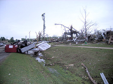 |
| In the picture: Everything was torn up by tornado (rated EF4) along Highway 365 in Mayflower (Faulkner County) on 04/27/2014. Click to enlarge. |
| Initially, a Tornado Warning was issued at 706 pm CDT. Four minutes later, the WSR-88D (Doppler Weather Radar) clearly showed a debris ball just to the north of Ferndale (Pulaski County), and it was certain to forecasters that a tornado was present and was causing damage. That prompted the first Tornado Emergency for Maumelle (Pulaski County) at 714 pm CDT. As the storm neared Morgan (Pulaski County), another Tornado Emergency went out at 720 pm CDT. Five minutes later, a tornado was confirmed by State Police at Roland (Pulaski County). A third Tornado Emergency was rolled out for Mayflower and Vilonia (both in Faulkner County) at 729 pm CDT: |
Tornado Emergency #1
SEVERE WEATHER STATEMENT
NATIONAL WEATHER SERVICE LITTLE ROCK AR
714 PM CDT SUN APR 27 2014

...TORNADO EMERGENCY FOR MAUMELLE...

...A TORNADO WARNING REMAINS IN EFFECT FOR NORTH CENTRAL SALINE...
WEST CENTRAL PULASKI...EAST CENTRAL PERRY AND SOUTHWESTERN FAULKNER
COUNTIES UNTIL 730 PM CDT...

AT 710 PM CDT...STORM SPOTTERS AND NATIONAL WEATHER SERVICE
METEOROLOGISTS WERE TRACKING A CONFIRMED TORNADO WITH REPORTS OF
DAMAGE.  THIS POTENTIALLY DEADLY TORNADO WAS LOCATED 5 MILES
SOUTHWEST OF LAKE MAUMELLE...MOVING NORTHEAST AT 45 MPH.

THIS IS A TORNADO EMERGENCY FOR MAUMELLE!. TAKE COVER NOW.

* LOCATIONS IN OR NEAR THE PATH OF THIS TORNADO INCLUDE...
  MAUMELLE...           LAKE MAUMELLE...      ROLAND...
  PINNACLE MTN...       MORGAN...             MAYFLOWER...
  MARCHE...             LITTLE ITALY...       PALARM...
  NATURAL STEPS...      FERNDALE...

THIS INCLUDES INTERSTATE 40 BETWEEN MILE MARKERS 133 AND 145.

PRECAUTIONARY/PREPAREDNESS ACTIONS...

TO REPEAT...A DAMAGING TORNADO IS ON THE GROUND. THIS IS AN
EXCEPTIONALLY DANGEROUS SITUATION. THIS STORM IS PRODUCING A LIFE
THREATENING...CONFIRMED TORNADO CAPABLE OF SIGNIFICANT DESTRUCTION.
TAKE COVER IMMEDIATELY.

&&
|
Tornado Emergency #1 (714 pm CDT) | Tornado Emergency #2 (720 pm CDT)
Tornado Emergency #3 (729 pm CDT) |
|
As the tornado raced to the northeast at 50 mph, there were additional Tornado Emergencies for Saltillo and Vilonia (both in Faulkner County) at 736 pm CDT and 743 pm CDT, for Vilonia (Faulkner County) at 748 pm CDT, and for El Paso and Floyd (both in White County) at 756 pm CDT.
Shortly after the tornado entered White County, radar showed circulation rapidly weakening. Forecasters were confident this tornado was gone. There were four more tornadoes farther northeast during the evening (produced by the same storm), but these were not as strong (rated EF0 to EF2). While these were covered by Tornado Warnings, there were no additional Tornado Emergencies.
|
|
|

