 |
| About This Page |
| Arkansas has had its share of historic events, many of which will be in our memories for years to come. |
|
|
 |
Severe Storms/Flooding in May, 2003 |
 |
| |
|
Several waves of severe weather affected the central United States during the first two weeks of May, 2003. There were more tornadoes spawned (over 500) than any other May since 1950. In Arkansas, the most memorable events were on the 4th and 16th, and close to three dozen tornadoes were counted.
|
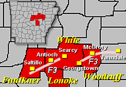 |
On the 4th, a widespread severe weather outbreak unfolded in the middle of the country during the afternoon and evening hours. In Arkansas, one prominent storm produced two destructive tornadoes (both rated F3). |
| In the picture: Two F3 tornadoes affected portions of Faulkner, Lonoke, White and Woodruff Counties during the evening of 05/04/2003. |
|
These long track tornadoes hit portions of Faulkner, Lonoke, White, and Woodruff Counties between 745 pm and 915 pm CDT.
|
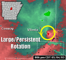 |
| In the picture: A large area of rotation passed just to the south of Vilonia (Faulkner County) at 806 pm on 05/04/2003. This rotation persisted across several counties, and was associated with an F3 tornado. |
|
Five other tornadoes (rated F0 to F2) were produced on the 4th in the Little Rock County Warning Area. The strongest of these tracked from just southeast of Guy (Faulkner County) to just northeast of Hopewell (Cleburne County). A damage survey revealed the following...
AT A FARM...A MOBILE HOME WAS DESTROYED. IT WAS BEING RENOVATED AND
NO ONE WAS IN IT. THE MOBILE HOME WAS THROWN AGAINST AN OLD MILKING
BARN...WHICH WAS ALSO DESTROYED. A TRAVEL TRAILER WAS TURNED UPSIDE
DOWN AND THE PERSON IN IT WAS INJURED. AN OLD CHICKEN HOUSE WAS ALSO
DESTROYED. A MOBILE HOME WAS DAMAGED...PRIMARILY DUE TO FLYING
DEBRIS.

ELSEWHERE ALONG THE PATH OF THE TORNADO...A COUPLE OF BARNS WERE
DESTROYED...SOME OUTBUILDINGS WERE DEMOLISHED...AND SEVERAL MOBILE
HOMES WERE DAMAGED. SEVERAL HOUSES WERE DAMAGED. THE MOST DAMAGE TO
ANY HOUSE WAS CAUSED BY FLYING DEBRIS THAT HAD BEEN TORN OFF A METAL
BARN. DOZENS OF LARGE TREES WERE BLOWN DOWN.
|
| Damage Pictures (May 4, 2003) |
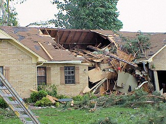 |
| In the picture: The roof of a home was partially ripped off in McCrory (Woodruff County). Click to enlarge. |
|
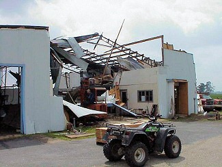 |
| In the picture: A large farm shop was destroyed just northeast of McCrory (Woodruff County) on Highway 64. Click to enlarge. |
|
| |
 |
| In the picture: Just northeast of McCrory (Woodruff County), a church suffered damage. Click to enlarge. |
|
 |
On the 16th, a strong storm system in Oklahoma approached Arkansas during the afternoon. Ahead of the system, two clusters of strong to severe thunderstorms developed. |
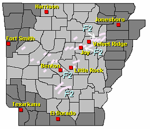
| In the picture: Twenty five tornadoes (rated F0 to F2) were spawned in the central third of Arkansas on 05/16/2003. |
|
The first cluster of storms produced several mostly small tornadoes in western Arkansas. Farther east, the cluster became increasingly more tornadic as it evolved into a bow echo. Numerous tornadoes were spawned, especially in Faulkner, White, and Jackson Counties. Here is more information...
A BOW ECHO OR BOOMERANG SHAPED LINE OF STORMS SWEPT ACROSS MUCH
OF FAULKNER...WHITE AND JACKSON COUNTIES. BOWS ARE OFTEN ASSOCIATED
WITH STRONG TO DAMAGING WINDS...AS WAS THIS PARTICULAR BOW. AT
TIMES...BOWS SPAWN TORNADOES...WITH SEVERAL TORNADOES PRODUCED AS
THE BOW MOVED QUICKLY TO THE EAST AND NORTHEAST. THE TORNADOES
WERE MOSTLY WEAK IN NATURE AND WERE ON THE GROUND FOR ONLY A FEW
MILES IN MOST CASES. THE BOW AND THE TORNADOES WERE RESPONSIBLE FOR
EXTENSIVE TREE DAMAGE...WITH TREES EITHER DOWNED OR SNAPPED. SOME
STRUCTURAL DAMAGE OCCURRED AS WELL...WITH MOSTLY ROOF DAMAGE
NOTED (DUE TO FALLEN TREES OR SHINGLES REMOVED). POWER LINES AND
POWER POLES WERE DOWNED AS WELL.
One of the strongest tornadoes (F2) produced during the event affected the Benton area (Saline County), with buildings heavily damaged at an auto dealership.
|
|
In addition to the tornadoes, heavy rainfall also occurred. Four to eight inches of rain fell from Newport (Jackson County) and Searcy (White County) westward toward Morrilton (Conway County). Widespread flash flooding was reported (creeks out of their banks, roads under water, bridges washed out, etc).
|
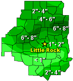 |
| In the picture: Twenty four hour rainfall through 700 am CDT on 05/17/2003. |
| Damage/Flood Pictures (May 16, 2003) |
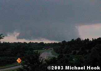 |
| In the picture: A wall cloud was witnessed over West Little Rock (Pulaski County). The photo is courtesy of Michael Hook. Click to enlarge. |
|
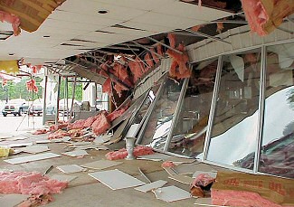 |
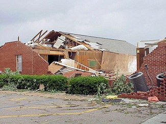
| In the picture: A sales building at an auto dealership was heavily damaged in Benton (Saline County). Click to enlarge. |
|
| |
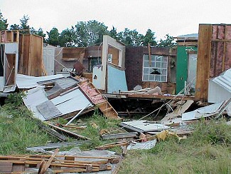 |
| In the picture: Northwest of Joy (White County), a mobile home was heavily damaged. The structure was unoccupied and was being renovated. Click to enlarge. |
|
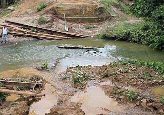 |
| In the picture: A bridge over Stevens Creek was washed away about 3 miles northwest of Velvet Ridge (White County). Click to enlarge. |
|
|
|

