 |
| Storm Reports |
| Are you interested in what happened during a recent event? Check out the report below. |
|
|
 |
Severe Storms on November 4, 2022 |
 |
| |
 |
| Surface Map | Temperatures/Dewpoints at 400 pm CDT |
| In the pictures: A storm system ("L") in the Texas panhandle dragged a cold front into Arkansas during the evening of 11/04/2022. Severe weather was likely ahead of the front, especially in the southwest where the environment was the most unstable (temperatures well into the 70s to lower 80s/dewpoints well into the 60s). |
|
| |
|
A very active evening was in store across Arkansas on November 4th. High temperatures were much above average, with readings in the 70s to lower 80s. Warmth and increasing moisture levels added enough energy to the atmosphere to fuel developing thunderstorms. The triggering mechanism was an incoming cold front from the southern Plains.
|
 |
| Risk of Severe Weather | CAPE/Shear at 700 pm CDT |
| In the pictures: According to an outlook from the Storm Prediction Center (in Norman, OK), there was an enhanced to moderate risk of severe weather from southwest into central Arkansas on 11/04/2022. This is where modest levels of CAPE (Convective Available Potential Energy/a measure of instability) and shear (wind energy to force storm development/drive storms/create rotation) came together. |
|
| |
|
Tornadoes and wind damage were the two main concerns. In fact, an outbreak of severe weather was expected, with the main focus from northeast Texas into southwest Arkansas.
|
|
|
| In the picture: Several rotation tracks were associated with severe storms moving from southwest to northeast across the western half of Arkansas during the evening of 11/04/2022. |
|
| |
|
Winds turned with height, and caused multiple storms to rotate in the area of greatest concern. Numerous Tornado Warnings were issued, with the event starting in eastern Oklahoma between 300 pm and 400 pm CDT. Here at home, storms arrived in the west shortly before 700 pm CDT.
|
| The Strongest Tornadoes |
|
The strongest and most destructive tornadoes during this event tracked from northeast Texas into southeast Oklahoma. There were two long track tornadoes (both rated EF4) of note. The first of these went from west of Paris, TX to southeast of Spencerville, OK (just to the east of Hugo Lake). This tornado pounded the Powderly, TX community, and was on the ground close to 45 miles. The second tornado cut a 58 mile swath from southwest of Clarksville, TX to east of Broken Bow, OK. The town of Idabel, OK was especially hard hit.
Fatalities are most likely with higher end (versus weak) tornadoes. That was the case this time around, with a least two deaths linked to these tornadoes.
|
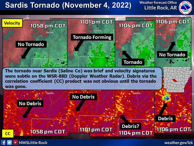 |
| In the picture: The tornado (rated EF2) near Sardis (Saline County) was brief and velocity signatures were subtle on the WSR-88D (Doppler Weather Radar) during the evening of 11/04/2022. Debris vis the correlation coefficient (CC) product was not obvious until the tornado was gone. |
|
| |
|
In the Little Rock County Warning Area, eight tornadoes were spawned. A tornado (rated EF2) was confirmed just to the south and east of Sardis (Saline County). This tornado was brief and somewhat difficult to pick out on the WSR-88D (Doppler Weather Radar). Debris from tornado damage was not prominently displayed until the tornado was gone. Warning for such a tornado (and most others during this event) was challenging.
|
| Tornadoes in Arkansas |
|
Sixteen (16) tornadoes were counted in Arkansas following the severe weather outbreak on November 4th. This is the most tornadoes for the month since November 27, 2005. On that day, two dozen tornadoes raked through northern and western sections of the state.
|
|
|
| |
|
Homes were damaged (mainly roofs), outbuildings were damaged or destroyed, and numerous trees were toppled or snapped. There was another tornado (rated EF2) just south and east of Kirby (Pike County) that ripped apart a barn.
|
|
|
| In the video: The WSR-88D (Doppler Weather Radar) at Fort Smith (Sebastian County) showed a lot of rotation (green/inbound winds adjacent to read/outbound winds) within a storm tracking from Idabel, OK to Wickes, AR from 655 pm to 800 pm CDT. |
|
| |
|
Toward the Oklahoma border, damage to chicken houses and trees was found near Wickes (Polk County). This was the result of a tornado (EF1). Two more tornadoes (both rated EF1) were identified between Gravelly and Bluffton (both in Yell County), and four to five miles southeast of Danville (Yell County). The tornadoes uprooted or splintered trees, and the latter tornado dismantled an outbuilding. There was a brief (0.4 mile path) tornado (rated EF1) south of Malvern (Hot Spring County), and a more persistent (7.7 mile path) tornado (rated EF1) south and east of Curtis (Clark County) that crossed the Ouachita River. These tornadoes were responsible for mostly tree damage. Finally, a tornado (EF1) traversed the Arkansas River north of Roseville (Logan County).
|
|
|
| |
|
In the Tulsa County Warning Area, the aforementioned Logan County tornado was one of three tornadoes tallied between Branch and Altus (both in Franklin County). Additional tornadoes were noted between Huntington and Mansfield (both in Sebastian County), northeast of Winslow (Washington County), and not far from Green Forest (Carroll County) and Huntsville (Madison County). All tornadoes were weak (rated EF0/EF1). One other tornado was detected on radar by a debris signature at Fort Chaffee (Sebastian County). However, the area could not be surveyed (a fire exercise was in progress), and the tornado was assigned an EFU (unknown) rating. In the Shreveport County Warning Area, homes and chicken houses were roughed up, a mobile home was rolled, and a cell tower collapsed north and west of Center Point (Howard County). A tornado (rated EF2) was to blame.
Elsewhere, the roof of an abandoned home collapsed, as did the roof of a boat storage facility in Henderson (Baxter County). It appears that damaging winds were the culprit. A tractor trailer was blown over along Interstate 30 at Fulton (Hempstead County). Trees and/or power lines were downed in Amity (Clark County), Cabot (Lonoke County), Cherry Hill (Polk County), Furlow (Lonoke County), northwest of Omaha (Boone County), and Pine Ridge (Montgomery County).
|
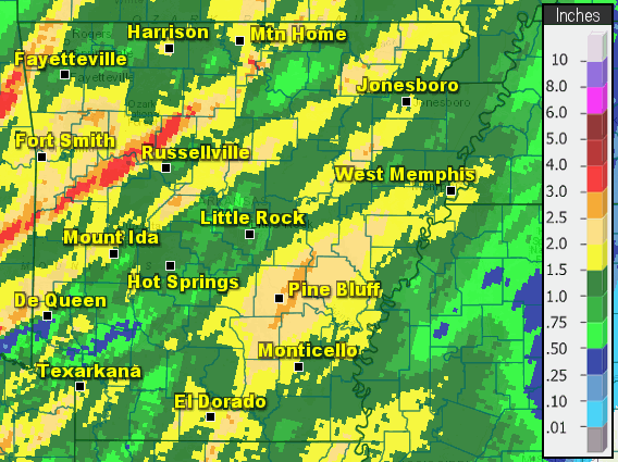 |
| In the picture: Twenty four hour rainfall through 700 am CDT on 11/05/2022. |
|
| |
|
As far as rainfall, one to more than three inch amounts were common across the region. Twenty four hour totals through 700 am CDT on the 5th included 3.55 inches at Subiaco (Logan County), 3.34 inches at Calico Rock (Izard County), 3.15 inches at Booneville (Logan County), 2.80 inches at Beedeville (Jackson County), 2.51 inches at Highfill (Benton County), 2.48 inches at Bogg Springs (Polk County), 2.47 inches at Salem (Fulton County), and 2.32 inches at Cane Creek State Park (Lincoln County) and Pine Bluff (Jefferson County).
Fort Smith (Sebastian County) had close to two inches of precipitation. This was on top of a wetter than usual October. Flash flooding was reported, and at least six people were rescued from vehicles stranded in high water.
|
|
|


