Are you interested in what happened during a recent event? Check out the report below.
Very Hot/Severe Storms/Heavy Rain on August 14-18, 2024
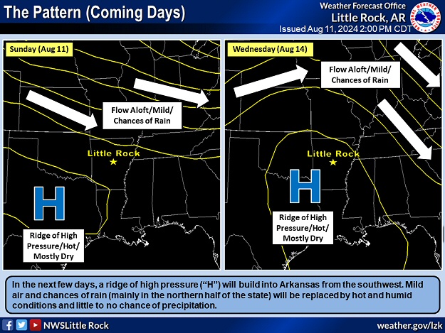
In the picture: A ridge of high pressure ("H") built over Arkansas by 08/14/2024. While rain was possible around the periphery of the ridge (in northern sections of the state), much of the region experienced oppressive conditions and got little to no precipitation.
A big ridge of high pressure built over Arkansas from the Plains in mid-August, and brought oppressive conditions to the area. Dangerous heat was mainly a concern in central and southern sections of the state. Away from the center of the high (toward the edge/periphery), the heat was not as intense across the northern counties, and there was at least some chance of rain.
7:10 AM-Rain and thunderstorms continue this morning from north-central to northeast parts of the state. The heaviest rain has fallen across parts of Fulton and Sharp Counties. #arwxpic.twitter.com/UMMU4QwOUF
In the video: The WSR-88D (Doppler Weather Radar) showed areas of heavy rain in north central and northeast Arkansas early on 08/14/2024.
On the 14th, heavy rain was realized north and east of Little Rock (Pulaski County). Amounts exceeded three inches at Hardy (Sharp County) and Salem (Fulton County) in the morning.
A couple of days later, the high temperature at Texarkana (Miller County) was 104 degrees. The thermometer showed 103 degrees at Little Rock (Pulaski County), Mount Ida (Montgomery County), and Russellville (Pope County), and 102 degrees at De Queen (Sevier County), Hot Springs (Garland County), Monticello (Drew County), and Pine Bluff (Jefferson County).
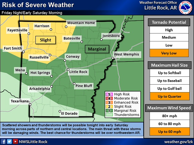
In the picture: There was a risk of severe thunderstorms on 08/16/2024, especially in northwest Arkansas during the evening hours.
In the afternoon, isolated severe storms popped up from southwest into central Arkansas. By evening, more storms (from southeast Kansas, northeast Oklahoma, and southwest Missouri) affected parts of the Ozark/Ouachita Mountains and the Arkansas River Valley west of Russellville (Pope County). Multiple trees were downed (by damaging straight-line winds) between Bismarck and DeRoche (both in Hot Spring County), with some trees on homes. Another tree fell on a house, two vehicles, and a storage shed about nine miles north-northeast of Dierks (Howard County), and trees were on structures at Bella Vista (Benton County). More trees were toppled at Charleston and Ozark (both in Franklin County). Camping trailers were overturned at Beaver Lake Dam (Carroll County). Just southwest of Figure Five (Crawford County), 80 to 90 mph winds uprooted trees and damaged roofs. A 64 mph gust was measured at Highfill (Benton County), and there was a 60 mph gust at Fort Smith (Sebastian County).
Here's a look at those severe storms as they came into Rogers tonight. Scattered wind damage across Benton county, & widespread power outages. Up to 30,000+ for a brief time, then dropping. Around 10,000 outages in Benton county as of 10:26pm#arwxpic.twitter.com/QcRMXUlYUp
In the video: Thunderstorms rolled into Rogers (Benton County) during the evening of 08/16/2024, and produced a lot of wind and lightning. More than 30,000 power outages were reported. The video is courtesy of Darby Bybee via X (formally Twitter).
Storms rolled into an outdoor hot air balloon and music festival (Soar NWA) in Bentonville (Benton County), and people scrambled to try and keep tents from blowing away. One of the tents hit a 12-year-old girl, and she was treated at a local hospital. At the festival, flames from a grass fire (started by a fireworks show) were fanned as winds increased. Fortunately, the fire did not spread beyond a small field.
During the wee hours of the 17th, storms in northeast Arkansas dumped enough rain to wash out bridges between Greenway and Rector (both in Clay County). There was quarter size hail in Rector (Clay County), and a 58 mph gust was recorded at Jonesboro (Craighead County). At Little Rock (Pulaski County), a 54 mph gust occurred.
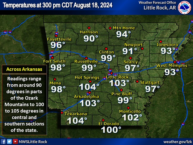
In the pictures: Oppressive conditions were noted across Arkansas on 08//18/2024. There were triple digit temperatures in central and southern sections of the state as of 300 pm CDT, and heat index values were largely between 100 and 120 degrees.
The hottest and most oppressive day of the period was the 18th. Temperatures reached 105 degrees or greater at De Queen (Sevier County), Hot Springs (Garland County), Little Rock (Pulaski County), Mount Ida (Montgomery County), and Texarkana (Miller County). Heat index values peaked from 110 to 120 degrees across the southern half of the state.
In the video: The satellite loop shows a large complex of thunderstorms diminishing in eastern Kansas, and followed by clusters of strong to severe storms in Arkansas between 1000 am and midnight CDT on 08/18/2024.
As the region baked, a cold front arrived from the north, and slowly pushed toward the Gulf Coast. Ahead of the front, another round of thunderstorms erupted during the afternoon and evening.
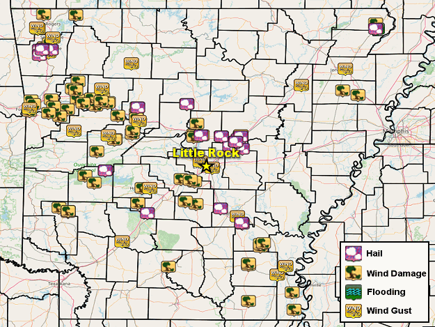
In the picture: Severe weather and flash flood reports on August 16-18, 2024.
Hen egg size hail (two inches in diameter) was reported at Ward (Lonoke County), with golf ball size hail near Story (Montgomery County), ping pong ball size hail at Farmington (Washington County), and half dollar size hail just southwest of El Paso (White County). Tree/some structural damage was extensive from Fayetteville (Washington County) to Altus (Franklin County), Clarksville (Johnson County), Russellville (Pope County), Centerville (Yell County), Hot Springs (Garland County), and Benton and Bryant (both in Saline County). It was the same story from Monticello (Drew County) to Lake Village and Eudora (both in Chicot County).
In the video: Damaging thunderstorm winds tore up this dock on Lake DeGray roughly four miles northwest of Caddo Valley (Clark County) on 08/18/2024. The video is courtesy of Brandon Cogburn via X (formally Twitter).
Docks were dismantled at a marina on Lake DeGray about four miles northwest of Caddo Valley (Clark County). There was a 64 mph gust at Highfill (Benton County), a 62 mph gust just east of McGehee (Desha County), a 60 mph gust close to Baxter (Drew County), and a 58 mph gust at Fayetteville (Washington County). Over 50,000 utility customers lost power.
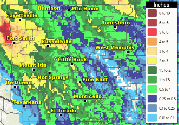
In the picture: Six day rainfall ending at 700 am CDT on 08/19/2024.
As far as rainfall, six day totals through 700 am CDT on the 19th included 4.61 inches at Salem (Fulton County), 4.34 inches at Long Pool (Pope County) and Mountainburg (Crawford County), 3.91 inches at Fort Smith (Sebastian County), 3.79 inches at Corning (Clay County), 3.45 inches at Hardy (Sharp County), 3.42 inches at Abbott (Scott County), 3.02 inches at Fayetteville (Washington County), and 3.00 inches at Saint Francis (Clay County). Interestingly, less than a tenth of an inch of precipitation settled the dust at Des Arc (Prairie County), El Dorado (Union County), Marianna (Lee County), and Stuttgart (Arkansas County).
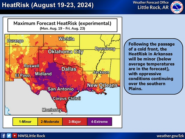
In the picture: Following the passage of a cold front on 08/18/2024, the HeatRisk in Arkansas was minor (below average temperatures in the forecast).
After the front passed through and exited to the south, it was a different world. A mild east/northeast wind ushered in very dry air/comfortable air and below average temperatures. By the 21st, morning lows were in the 50s/60s, with afternoon highs in the 80s to lower 90s.