Are you interested in what happened during a recent event? Check out the report below.
Severe Storms on April 15, 2023
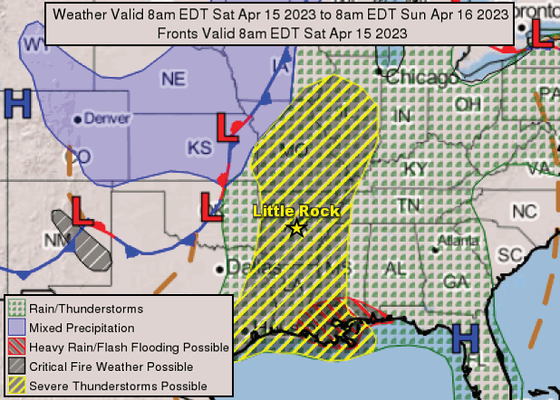
In the picture: A cold front swept into Arkansas from the west on 04/15/2023. Ahead of the front, severe weather was likely across the state.
In mid-April, a cold front was on the horizon in the Plains. Ahead of the front, temperatures in much of Arkansas were in the 80s on the 15th, and the warmth/increasing moisture levels provided plenty of fuel for thunderstorm development.
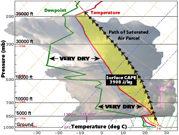
In the picture: The sounding (temperature and dewpoint profile with height) at the North Little Rock Airport (Pulaski County) revealed a very unstable atmosphere at 100 pm CDT on 04/15/2023. Saturated air parcels were much warmer than the environmental temperature (arrows to the right of the red line), leading to very high values of CAPE (Convective Available Potential Energy/a measure of instability). CAPE is directly related to updraft strength, and the parcels ascended rapidly to make clouds/storms. As moisture was driven into dry air overhead, evaporation led to rapid cooling and the formation of ice/hail.
As of 100 pm CDT, there were no storms yet. A sounding (temperature and dewpoint profile with height) revealed plenty of instability, and it was just a matter of time before the fireworks began. There was also a lot of dry air aloft, and forecasters knew this would likely lead to very large hail. Low level moisture driven into this dry environment overhead would create a lot of evaporation/cooling, making it easy for ice to form.
In the video: The satellite showed explosive development of thunderstorms in northern and western Arkansas between 200 pm and 500 pm CDT on 04/15/2023. Storms continued popping up farther south/east into the evening as a cold front surged into the state from the Plains.
Between 230 pm and 330 pm CDT, thunderstorms developed rapidly in northwest and west central Arkansas. During this time frame, tennis ball size hail was reported at Alma and Mulberry (both in Crawford County), with hen egg size hail at Dyer (Crawford County), Garfield (Benton County), and Fort Smith (Sebastian County).
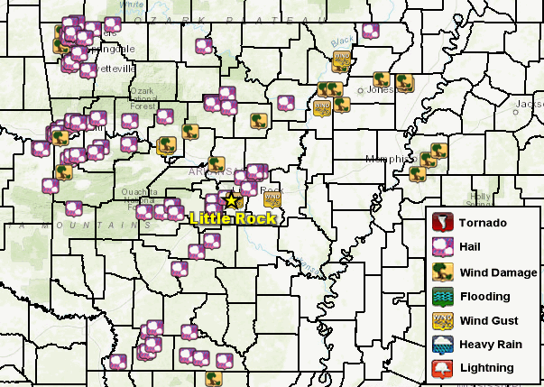
In the picture: There were numerous reports of large hail, damaging wind, and high wind gusts on 04/15/2023.
Farther south/east, baseball size hail occurred about six miles southwest of Magnolia (Columbia County), with hen egg to tennis ball size stones near Botkinburg (Van Buren County) and south of Joan (Clark County), and golf ball size stones northwest of Ozark (Franklin County), Shirley (Van Buren County), northwest of Tag (Pope County), and Witcherville (Sebastian County).
A 66 mph wind gust was measured at Newport (Jackson County), with a 61 mph gust at McCreanor (Lonoke County), and gusts to 60 mph southwest of Bentonville (Benton County) and at Russellville (Pope County). At College City (Lawrence County) and Little Rock (Pulaski County), 56 mph gusts were recorded.
In the picture: Following a very turbulent day, these striking mammatus clouds were illuminated by the sun at Conway (Faulkner County) toward evening on 04/15/2023. The photo is courtesy of Tyler Sorrells via Twitter.
At Highfill (Benton County), trees were downed and a horse shed was damaged. Trees were also toppled at Conway (Faulkner County), near Manilla (Mississippi County), northeast of Russellville (Pope County), Swifton (Jackson County), Walnut Ridge (Lawrence County), and northwest of Wilburn (Cleburne County). Outbuildings were damaged east of Jerusalem (Conway County). Southwest of Egypt (Craighead County), a tractor trailer was overturned on Highway 67.
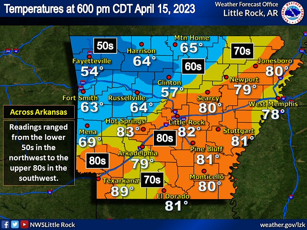
In the picture: Temperatures at 600 pm CDT on 04/15/2023. Readings ranged from the lower 50s in northwest Arkansas to the upper 80s in the southwest.
Much cooler air followed the storms. By 600 pm CDT, temperatures were in the 50s and 60s across much of northern and western Arkansas. At Little Rock (Pulaski County), the thermometer showed 81 degrees at 655 pm CDT. Fifteen minutes later, the mercury dropped to 60 degrees! In addition, 1.71 inches of rain fell in an hour (ending at 753 pm CDT). While this was a lot of precipitation in a short time locally, most locations did not receive nearly this much liquid (quarter to three quarter inch totals were common).
Outside of Arkansas
A few days prior to this event, a ridiculous 25.91 inches of rain came down at Fort Lauderdale, FL on April 12th, shattering the previous one day record of 14.59 inches (on April 25, 1979). There was water everywhere, and it shut down the airport, turned roads into lakes, stranded hundreds of vehicles, and sent dozens of homeowners to shelters. Given a life threatening situation, the mayor declared a state of emergency.