 |
| Storm Reports |
| Are you interested in what happened during a recent event? Check out the report below. |
|
|
 |
Severe Storms/Heavy Rain on April 4-6, 2023 |
 |
| |
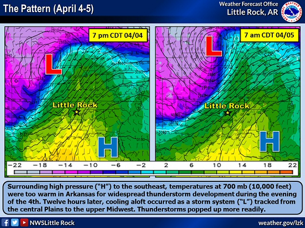 |
| In the picture: Surrounding high pressure ("H") to the southeast, temperatures (shaded/in degrees C) at 700 mb (10,000 feet) were too warm in Arkansas for widespread thunderstorm development during the evening of 04/04/2023. Twelve hours later, cooling aloft occurred as a storm system ("L") tracked from the central Plains to the upper Midwest. Thunderstorms popped up more readily. At Springfield, MO, the 700 mb temperature went from 7.8 to 4.6 degrees C. Data is courtesy of the College of DuPage. |
|
| |
|
Here we go again. After an outbreak of severe weather on March 31st, Arkansans had to deal with more severe storms late on April 4th and into the 5th. Leading up to the event, temperatures were well above average on the 4th, with readings in the upper 70s to upper 80s. The thermometer peaked at 89 degrees at Little Rock (Pulaski County), and 88 degrees at Benton (Saline County) and Monticello (Drew County).
Fortunately, the event was delayed locally because the atmosphere was too warm aloft. For thunderstorms to develop readily, air parcels containing moisture must remain warmer than the surrounding environment to ascend and build clouds. If the parcels encounter warmer air overhead (an inversion), this stops/caps the rising motion, and it stays largely quiet. This was the pattern through the late evening of the 4th, and then it got loud.
|
|
|
| In the picture: Once a capping inversion broke, and strong to severe thunderstorms started developing north of Little Rock (Pulaski County), a Tornado Watch was posted (by the Storm Prediction Center in Norman, OK) for much of the northern half of Arkansas into southern Missouri at 130 am CDT (through 900 am CDT) on 04/05/2023. |
|
| |
|
Cooling took place overhead during the early morning hours of the 5th, and this allowed scattered severe thunderstorms to pop up in northern Arkansas. Straight-line wind estimated at 75 to 85 mph roughed up homes and barns around Sydney (Sharp County) and heavily damaged a middle school (especially the roof) at Berryville (Carroll County). A brief tornado (rated EF0) toppled trees not far from Weathers (Madison County). Another tornado (rated EFU, where "U" is unknown because no damage was found) was confirmed by radar and video/photographs near Oak Grove (Carroll County). Tennis ball size hail occurred at Ash Flat (Sharp County), with hen egg size stones at Cherokee Village (Fulton/Sharp Counties).
|
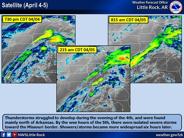 |
| In the picture: Satellite showed thunderstorms struggling to develop during the evening of 04/04/2023, and were found mainly north of Arkansas. By the wee hours of the 5th, there were isolated severe storms toward the Missouri border. Showers/storms became more widespread six hours later. |
|
| |
|
After sunrise, a line of showers and strong to severe thunderstorms surged through the state from the west. This happened as a powerful storm system in the upper Midwest dragged a cold front across the region. Trees were blown down at Bradley (Lafayette County), near Center Ridge (Conway County), west of Fouke (Miller County), Fox (Stone County), and Marked Tree (Poinsett County). A metal outbuilding was damaged a few miles south of Wynne (Cross County). A semi truck was tipped over on Interstate 55 east of Birdsong (Mississippi County).
|
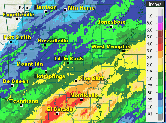 |
| In the picture: Twenty four hour rainfall through 600 am CDT on 04/06/2023. |
|
| |
|
The front eventually stalled along the Gulf Coast. North of the front, areas of heavy rain were noted in southeast Arkansas through the overnight hours of the 5th and into the 6th. More than three inches of precipitation dumped in places, including Cane Creek State Park (Lincoln County), El Dorado (Union County), and Monticello (Drew County). At the latter location, a portion of Highway 278 was closed due to flooding. Conditions were much cooler, with temperatures largely in the 50s at 100 pm CDT on the 6th.
|
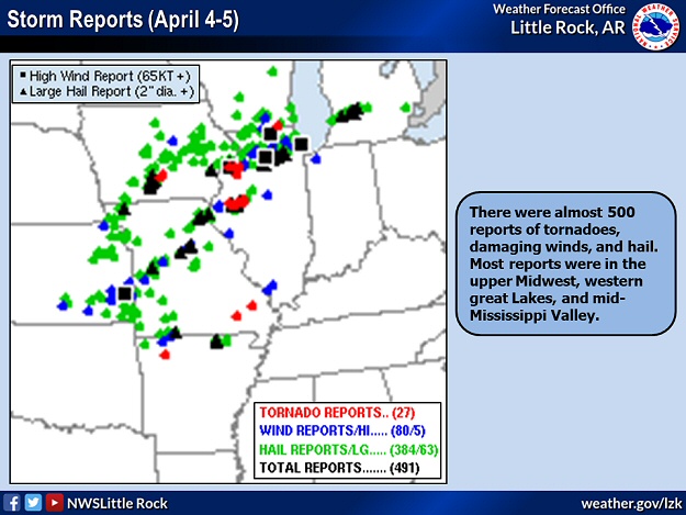 |
| In the picture: There were almost 500 reports of tornadoes, damaging winds, and hail in the twenty four hour period ending at 700 am CDT on 04/05/2023. Most reports were in the upper Midwest, western Great Lakes, and mid-Mississippi Valley. |
|
| |
|
Outside of Arkansas, tornadoes were spawned in parts of Iowa, Illinois, and Missouri on the 4th/early on the 5th. There were many instances of very large hail ranging in size from tennis balls to slightly bigger than baseballs. Around 330 am CDT on the 5th, a deadly tornado (rated EF2) ripped through Glenallen, MO. Mobile homes were destroyed and houses were dismantled. Numerous trees were snapped near the ground. Tragically, five fatalities were counted.
|
|
|

