 |
| Storm Reports |
| Are you interested in what happened during a recent event? Check out the report below. |
|
|
 |
Severe Storms/Flash Flooding on April 11-13, 2022 |
 |
| |
|
|
| |
|
The signs were ominous in mid-April. There would be a prolonged period of severe weather over the middle of the country, and Arkansas was in the crosshairs. It all got started on the 11th.
|
|
|
| In the picture: The surface map showed a large temperature (dashed lines) contrast across a front and near a storm system ("L") in northeast Oklahoma at 400 pm CDT on 04/11/2022. Readings were in the 50s from southern Missouri into northwest Arkansas, with 80s incoming from the southwest. This created an unstable environment which helped trigger thunderstorms. Moisture levels were on the rise, with dewpoints (shaded) in the lower to mid 60s across much of the region. This fueled thunderstorms as they developed. |
|
| |
|
A front was nearly stationary in northwest sections of the state, and separated cool air to its north (temperatures in the 50s) from much warmer conditions to the southwest (readings in the 80s). Very dry air just a day ago was replaced by moisture (dewpoints in the 60s). Given a destabilizing atmosphere (contrasting temperatures/increasing humidity/a front to get things going), thunderstorms were a sure bet.
|
|
|
| In the picture: This supercell and its corkscrew appearance was captured near Subiaco (Logan County) during the afternoon of 04/11/2022. The photo is courtesy of Tony Eason via Twitter. |
|
| |
|
Once thunderstorms erupted, it was clear that tornadoes were possible. Not only were there signs of rotation on radar, photos through social media showed supercells with a corkscrew appearance.
Between 500 pm and 600 pm CDT, two weak tornadoes (both rated EF1) were spawned near Bloomer (Sebastian County) and just south/east of Charleston (Franklin County). The tornadoes uprooted or snapped trees, and damaged a home and some outbuildings. By 630 pm CDT, there was another weak tornado (rated EF1) east/northeast of Scranton (Logan County). A chicken house and barn were both hit.
|
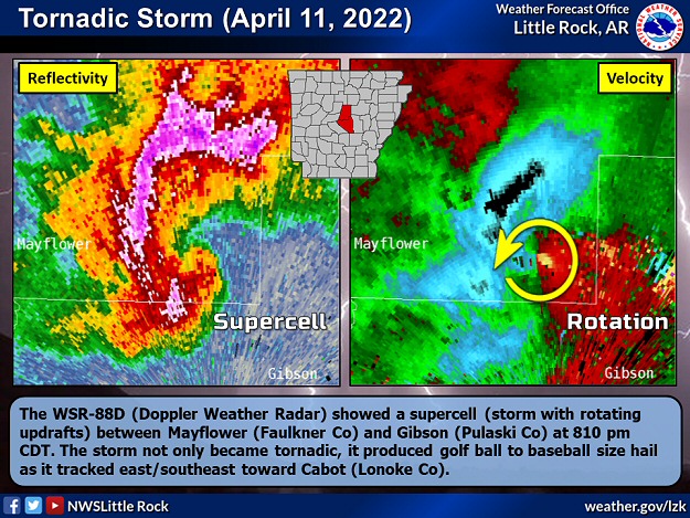 |
| In the picture: The WSR-88D (Doppler Weather Radar) showed a supercell (storm with rotating updrafts) between Mayflower (Faulkner County) and Gibson (Pulaski County) at 810 pm CDT on 04/11/2022. The storm not only became tornadic, it produced golf ball to baseball size hail as it tracked to the east/southeast toward Cabot (Lonoke County). |
|
| |
|
Not long after 800 pm CDT, things got scary just north of the Little Rock (Pulaski County) area. A tornado rapidly evolved southeast of Mayflower (Faulkner County). A funnel was sighted and damage to homes was reported.
|
|
|
| |
| A Tornado Emergency was declared for points downstream, including the Little Rock Air Force Base and Jacksonville (both in Pulaski County). Fortunately, the tornado stayed in a heavily wooded area on the north side of Camp Robinson (U.S. Army training grounds), and avoided populated areas. Based on video supplied by a military helicopter pilot surveying the area (mostly showing extensive tree damage), the tornado was given an EF1 rating. |
|
|
| In the picture: Very large hail was noted near New Blaine (Logan County) on 04/11/2022. The video is courtesy of Brian Emfinger via Twitter. |
|
| |
|
While the tornadoes (four of them) on the 11th garnered a lot of attention, the big story of the day was hail...and lots of it. There were over two dozen reports of golf ball size hail or larger. Hail larger than softballs (4.5 inches in diameter) was witnessed near New Blaine (Logan County), with baseball size stones at Branch and Charleston (both in Franklin County), just west of Delaware (Logan County), a few miles north of Mayflower (Faulkner County), and around Cabot (Lonoke County). The hail dented vehicles, cracked windshields, broke windows in homes, poked holes in siding, and pelted roofs.
|
| How Rare is Huge Hail? |
|
With the exception of 2005 and 2013, baseball size or larger hail was observed in Arkansas at least once a year since 1980 (through 2021). Hail at least softball size occurred once every other year (21 of 42 years). As far as numbers of reports, of the roughly 5,859 instances of quarter size or larger hail, 2,475 were at least golf balls (42.2% of reports), 256 were at least baseballs (4.4% of reports), and 50 were at least softballs (0.9% of reports). The largest hailstones were five inches in diameter (slightly larger than a DVD) on January 21, 1999; April 2, 2006; and May 4, 2020.
|
|
On the 12th, it appeared that we would get a little time to breathe, and that was the case. Severe weather stayed mostly to the south and west, but an isolated severe storm blew down trees along Highway 371 in Prescott (Nevada County). It was determined that a weak tornado (rated EF0) was responsible.
It was much more active in Texas, with a powerful tornado (rated EF3/maximum winds around 165 mph) ripping a roughly thirteen mile path of destruction through Salado, TX. More than twenty people were injured. Monster five to six inch diameter hail also pummeled the community. In Iowa, two tornadoes (both rated EF2) cut narrow swaths through areas twenty to thirty miles northwest of Fort Dodge, IA. Overall, more than a half dozen tornadoes were counted.
|
|
|
| In the picture: Seventy two hour estimated snowfall through 700 pm CDT on 04/14/2022. |
|
| |
|
Toward the Canadian border, much colder air and windy conditions from Montana into North Dakota led to heavy snow (two to four foot accumulations in some cases) and blizzard conditions. Billings, MT recorded 13.9 inches of snow on the 12th, which was the largest one day total in forty years (since 15.0 inches fell on May 11, 1981). A five hundred mile stretch of Interstate 94 was shut down.
|
 |
| In the picture: The most unstable air at 200 pm CDT on 04/13/2022 was in southern and eastern Arkansas where temperatures were in the 70s. Meanwhile, cooler air poured into northwest sections of the state, with readings in the 40s. |
|
| |
|
Arkansas was back in the game on the 13th. As the afternoon approached, colder air started surging into the state from the Plains. It was too cool (temperatures in the 40s/50s) for severe weather in the north/west. The focus was on the south/east (much warmer), with strong to damaging winds and isolated tornadoes the main concerns.
|
 |
| In the picture: The WSR-88D (Doppler Weather Radar) showed bowing segments (backward C-shaped lines of storms) sweeping across southern and eastern Arkansas at 412 pm CDT on 04/13/2022. Given a fast movement (60 to 70+ mph), chances for damaging winds were elevated. |
|
| |
|
Storms in the south/east rocketed to the east (60 to 70+ mph at times), and they bowed out (backward C-shaped) as powerful winds punched through from behind.
Shortly before 100 pm CDT, a bowing line of storms toppled trees at the zoo in Little Rock (Pulaski County), and there was some structural damage as well. The zoo had to be closed temporarily as a result. Around 230 pm CDT, a 66 mph gust was measured at Jonesboro (Craighead County) as storms passed through. Close to 430 pm CDT, there was 82 mph gust near DeWitt (Arkansas County).
|
|
|
| In the picture: Severe weather reports on April 11-13, 2022. Hail and isolated tornadoes were concentrated from west central into central Arkansas on the 11th. There was a lull on the 12th (except for a brief tornado in the southwest), with wind damage and flash flooding (and a tornado) from southern into central/eastern sections of the state on the 13th. There was also flash flooding in the north on the 13th. |
|
| |
|
Elsewhere, trees and/or powerlines/utility poles were downed and power was out south of Brinkley (Monroe County), at Bryant (Saline County), Helena-West Helena (Phillips County), Malvern (Hot Spring County), Hope (Hempstead County), Lepanto (Poinsett County), Monticello (Drew County), Paragould (Greene County), Russellville (Pope County), south of Stuttgart (Arkansas County), Walnut Ridge (Lawrence County), and Ward (Lonoke County). At Rison (Cleveland County), a tree fell on a mobile home, and a twenty year old woman was killed.
About three miles south of Etowah (Mississippi County), a brief weak tornado (rated EF0) ripped part of a roof from an abandoned school building. Two more weak tornadoes (rated EF0/EF1) were identified between Brookland and Monette (both in Craighead County), and Leachville (Mississippi County) and Hornersville, MO. The tornadoes damaged high tension power poles, trees, roofs, and irrigation pivots.
Storms exited by the late afternoon of the 13th, but continued to wreak havoc during the evening from Ohio and Indiana southward though the Tennessee Valley and the central Gulf Coast. At least eight mostly weak tornadoes (rated EF0/EF1) were confirmed in central Kentucky, including at Louisville, KY.
|
 |
| In the picture: Ninety six hour (four day) rainfall through 700 am CDT on 04/14/2022. |
|
| |
|
From the 11th through the 13th, two to over three inches of rain dumped from southwest through central and northeast Arkansas including Texarkana (Miller County), Sheridan (Grant County), Searcy (White County), Jonesboro (Craighead County), and West Memphis (Crittenden County). There were similar amounts in the northwest at Harrison (Boone County) and Highfill (Benton County), and also the far southeast.
On the 13th, a vehicle was swept off the road by high water at Flippin (Marion County), and the driver had to he rescued. About four miles southeast of Berryville (Carroll County), a motorist (70-year-old woman) attempted to drive through a low water crossing and did not make it. The vehicle was found, but the driver had drowned. Highways 16 and 412 were were under water southeast of Siloam Springs (Benton County). A high school was flooded at Cave City (Sharp County), and water covered roads at Bryant (Saline County), Harrison (Boone County), and North Little Rock (Pulaski County).
|
 |
| In the picture: Minor flooding was occurring along portions of the Black, Cache, Ouachita, and lower White Rivers on 04/15/2022. |
|
| |
|
There was enough rain to keep several tributaries above flood stage. Minor flooding continued at forecast points along the Black, Cache, Ouachita, and lower White Rivers (in eastern Arkansas).
|
|
|
There were numerous reports of very large hail and damaging winds on April 11th and 13th, and several instances of tornadoes and flash flooding. For a look at the reports, click here.
|
| In the picture: Preliminary reports of severe weather, heavy rain, and flash flooding in the Little Rock County Warning Area on April 11-13, 2022 (in red). |
| |
|
|


