|
| Storm Reports |
| Are you interested in what happened during a recent event? Check out the report below. |
|
|
 |
Destructive Tornadoes on March 31, 2023 |
 |
| |
 |
| In the picture: The highest severe weather potential (a moderate to high risk) on 03/31/2023 existed where the most lift (from the central Plains toward the mid-Mississippi Valley) overlapped the most unstable air (from the Texas Gulf Coast toward the Tennessee Valley). This included parts of Arkansas. |
|
| |
|
March is supposed to go out like a lamb, but not in 2023. It wasn't even close. Instead, an outbreak of severe weather occurred from Iowa to Arkansas and areas farther east through the Ohio and Tennessee Valleys on the 31st.
|
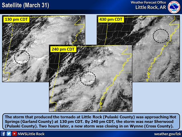 |
| In the picture: The supercell (storm with rotating updrafts) that produced the tornado at Little Rock (Pulaski County) on 03/31/2023 was approaching Hot Springs (Garland County) at 130 pm CDT. By 240 pm CDT, the storm was near Sherwood (Pulaski County). Two hours later, a new supercell was closing in on Wynne (Cross County). |
|
| |
|
In Arkansas, a nightmare was about to unfold in central sections of the state. It felt like something bad was going to happen, with temperatures in the 70s to lower 80s by 100 pm CDT (and some upper 60s toward the Missouri border). A supercell (storm with rotating updrafts) showed signs of becoming tornadic from northern Pike County into southwest Saline County during the early afternoon. In fact, there was a funnel cloud reported near Pearcy (Garland County) at 118 pm CDT.
|
|
|
| |
|
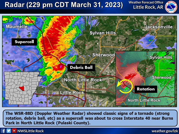
As the storm closed in on the Little Rock (Pulaski County) area, a Tornado Warning was issued at 203 pm CDT. It went downhill from there. A tornado quickly spun up at 218 pm CDT and began causing destruction about five miles west-southwest of the intersection of Interstates 430 and 630. When it was clear the situation was becoming catastrophic/life threatening, a Tornado Emergency was posted at 228 pm CDT.
|
|
|
| |
|
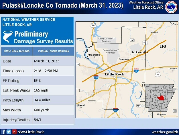
The tornado (rated EF3/165 mph peak wind) tracked just over thirty four miles from west Little Rock through North Little Rock, Sherwood and Jacksonville (all in Pulaski County) before finally weakening on the southeast side of Cabot (Lonoke County). There were at least 2,700 structures impacted and 60,000 power outages (many of these in Pulaski County). More than fifty people were injured and admitted to hospitals. Miraculously, only one person was killed.
|
|
|
| |
|
Some of the worst damage happened in west Little Rock (Pulaski County) between Napa Valley Drive and Interstate 430, and also in Jacksonville (Pulaski County).
|
| The Value of NOAA Weather Radio |
|
The first Tornado Warning for Pulaski County went out at 203 pm CDT on March 31st. A tornado was on the ground fifteen minutes later. From that time until the tornado exited into Lonoke County (to the east), six additional warnings (including Tornado Emergencies) and statements were disseminated by the National Weather Service. These products updated the public on the position and direction of the "confirmed large and destructive" tornado. The local broadcast media had wall-to-wall coverage of the situation, and offered radar perspectives, glimpses of the tornado, and reports of damage. Much of the same information was available via social media. The tornado reached Jacksonville (Pulaski County) at 245 pm CDT, and folks at a veterinary clinic were about to get hit. It should not have been a surprise, but nobody was prepared. "There was no advance warning," said a lady that worked at the clinic. This statement seems ridiculous, but it makes sense considering full attention was on the job and not the weather. If the clinic had a NOAA Weather Radio (a $35 to $40 purchase), and Pulaski County was programmed into the device, a very loud alarm would have sounded (assuming the equipment was in good working order). If nothing else, NOAA Weather Radio is the attention-getter needed when severe storms are approaching, everything is turned off (i.e. television, radio, cell phone, etc), and your mind is somewhere else (maybe even asleep).
|
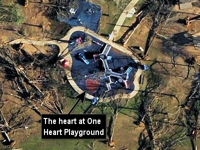 |
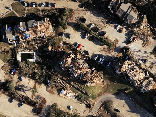
At these locations, the top floor of apartment buildings were badly roughed up or removed, and houses and a church were leveled. At Burns Park in North Little Rock (Pulaski County), at least 10,000 trees were lost.
|
| In the picture: At Burns Park in North Little Rock (Pulaski County), a tornado (rated EF3) downed a lot of trees around One Heart Playground on 03/31/2023. However, the playground survived. Opened in 2017, this inclusive playground allows allows kids with and without disabilities to play together. Following the tornado, one of our forecasters posted this on Twitter with before and after photos of the playground: "In such a short and terrifying moment, the forests blow down and catastrophe thrusts itself upon us. The world as we know it ends. Still, the heart perseveres and new life is born from even the greatest of tragedies." Click the photo to enlarge. |
|
|
| |
|
In the city of Little Rock (Pulaski County), the last tornado rated this high occurred on January 21, 1999 (as part of a state record outbreak of fifty six tornadoes). This tornado (rated F3) went twenty two miles from Shannon Hills (Saline County) to Sherwood (Pulaski County), and hit a historic district in Little Rock (Pulaski County). Several homes built at the turn of the 20th century were heavily damaged. Even the Governor's mansion was not spared, with a tree falling on a fence around the property. A grocery store was ripped apart as well. Three people lost their lives.
|
| Twenty Seconds |
|
When March 31st began, it was business as usual at a small company on North Shackleford Road. That was until 225 pm CDT. A video showed the owner standing outside with an employee, and they witnessed an incoming tornado through the trees. They ran inside the building, and the video kept rolling. They were focused on an open overhead door on the south side of the structure, and had a front row seat at the most unforgettable and unforgiving performance Mother Nature could offer. Winds quickly reached surreal speeds approaching 165 mph. A shed flew by the door, paper and other small items shot down a hallway through the opening, and trees magically disappeared. A Jeep rolled into view. The show was over in twenty seconds. Miraculously, while their hiding place lost part of a roof and shifted somewhat, it remained mostly intact. When they walked outside, the world had drastically changed and was difficult to comprehend. "Oh my gosh," said the owner in disbelief. The neighborhood they knew was gone, and was replaced by piles of rubble and a few mangled tree trunks. Just like that, as if in a bad dream, business as usual was no more.
|
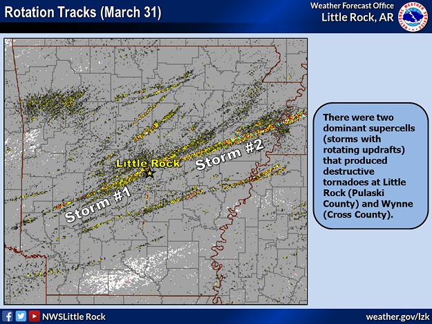 |
| In the picture: Rotation tracks indicated there were two dominant supercells (storms with rotating updrafts) that produced destructive tornadoes at Little Rock (Pulaski County) and Wynne (Cross County) on 03/31/2023. |
|
| |
|
Farther east, a separate supercell spawned a tornado (rated at least EF3) that carved a path through Wynne (Cross County) around 445 pm CDT. Structures were obliterated, and at least four fatalities resulted. Farther downstream, the same tornado wreaked havoc (i.e. homes damaged or destroyed and trees uprooted or snapped) just west of Parkin (Cross County) and north of Earle (Crittenden County). South of Turrell (Crittenden County), a truck was tipped over on Interstate 55. The tornado eventually crossed the Mississippi River and dissipated near Burlison, TN (a 73 mile trek).
Another brief and weak tornado (rated EF1) destroyed a barn about five miles southeast of Hickory Plains (Prairie County) at 345 pm CDT. Between Alco and Fifty-Six (both in Stone County), a stronger tornado (rated EF2) shifted a house off of its foundation and removed the roof at 449 pm CDT. Close to Lexa (Phillips County), a funnel touched down over open fields at 703 pm CDT and did not cause any damage. This tornado was rated EFU (where "U" is unknown).
Hail to the size of hen eggs was reported at McCaskill (Hempstead County), with golf ball size stones west of Casscoe (Arkansas County), Sheridan (Grant County), and east of Tollette (Hempstead County).
|
| Stay in School or Go Home |
|
Tornadoes were coming on March 31st, and school superintendents had a lot to consider. If children are kept in school, and one or more facilities take a direct hit, the result could be tragic and unbearable. Liability becomes a huge worry. But since eight out of ten tornadoes are weak, and their paths are narrow, the probability of a disaster is slim. If kids are sent home, they are hopefully surrounded and comforted by family as anxiety ramps up. But they are spread out and not at one place, and chances of encountering a tornado go up. In addition, the construction of school buildings might actually be superior to many houses. In the Little Rock (Pulaski County) area, both options (stay in school or go home) were used by various districts prior to the arrival of the tornado (rated EF3) that caused so much destruction. Luckily, both choices yielded a mostly happy ending given an event total of only one fatality. At Wynne (Cross County), it was decided to shut down classes early. That was several hours before the local high school was gutted by a tornado (rated EF3). Students and faculty were out of harm's way, and lives were saved. Administrators were rightfully viewed as heroes. They certainly had a tough call to make. If faced with a similar situation, what would you do?
|
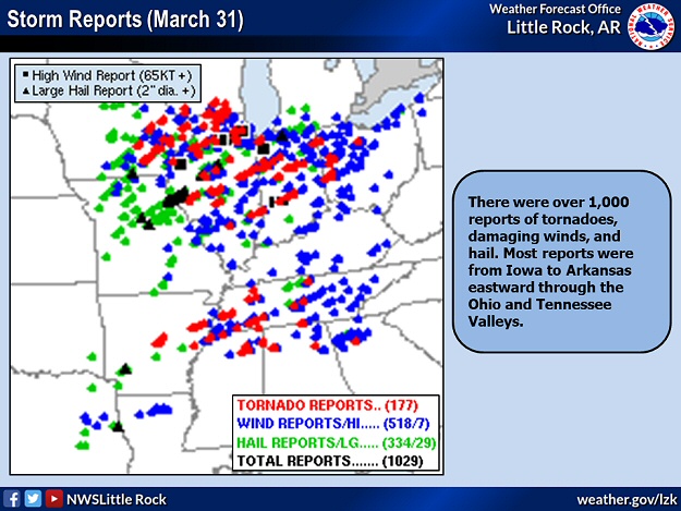 |
| In the picture: There were over 1,000 reports of tornadoes, damaging winds, and hail on 03/31/2023. Most reports were from Iowa to Arkansas eastward through the Ohio and Tennessee Valleys. |
|
| |
|
Overall, this event featured over a thousand reports of tornadoes, damaging wind, and large hail. The majority of the reports were north/east of Arkansas. There were 147 tornadoes (including those tallied on April 1st), and a dozen of these were rated EF3 or higher.
|
| One for the Record Books |
|
The severe weather outbreak of March 31st/April 1st, 2023 made the Top 3 list for the number of tornadoes produced in a twenty four hour period. An impressive 137 tornadoes were documented (with 147 tornadoes during the entire outbreak). In case you are wondering, number one and two on the list are the super outbreaks of April 25th through the 28th, 2011 (216 tornadoes) and April 3rd and 4th, 1974 (148 tornadoes).
|
|
The strongest tornado (rated EF4) was on the ground forty three miles from Ottumwa, IA to Iowa City, IA. The deadliest tornado (rated EF3) had an eighty six mile path from south of Hornsby, TN to east of Hohenwald, TN, and was responsible for nine fatalities. Six people were killed by a tornado (rated EF3) that went from Sainte Marie, IL to Sullivan, IN (forty one miles). On April 1st, a rare EF3 tornado was documented in southern Delaware. It tied for the strongest tornado in state history (with a similarly rated tornado in April, 1961).
|
|
|