|
| Storm Reports |
| Are you interested in what happened during a recent event? Check out the report below. |
|
|
 |
Severe Storms/Heavy Rain on March 1-3, 2023 |
 |
| |
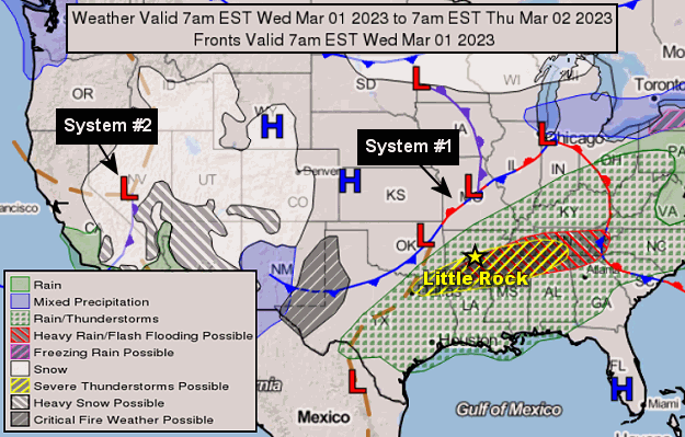 |
| In the picture: The forecast map showed a storm system/cold front (System #1) set to move into Arkansas from the Plains on 03/01/2023. Severe weather was expected ahead of the front from central into southern sections of the state. Not far behind was a powerful area of low pressure (System #2) in the western United States, with severe storms/flooding on the menu the next day. |
|
| |
|
We were in for a double whammy (two episodes) of severe weather to begin March. In other words, March definitely came in like a lion. It all began on the 1st, with a cold front arriving from the Plains and moving into a springlike environment.
|
|
|
| |
|
Temperatures on the 1st maxed out in the 70s/80s, which was well above normal highs in the mid 50s to mid 60s. Some readings of note included 88 degrees at Texarkana (Miller County), 84 degrees at Camden (Ouachita County) and El Dorado (Union County), and 83 degrees at Fort Smith (Sebastian County) and Monticello (Drew County).
As the air heated up, and the atmosphere destabilized, severe thunderstorms were triggered by the front during the late afternoon and evening. The storms produced very large hail, and also caused spotty wind damage.
|
|
|
| |
|
Hail slightly larger than baseballs was reported at Woodlawn (Cleveland County), with ping pong ball size stones near Benton (Saline County) and west of Stuttgart (Arkansas County), and half dollar size hail a few miles north of Norman (Montgomery County). At Rison (Cleveland County), wind gusts up to 85 mph ripped the roof off of a church and a strip mall. Part of a brick facade was removed from latter structure. Trees were also toppled, with one tree blocking Highway 79.
|
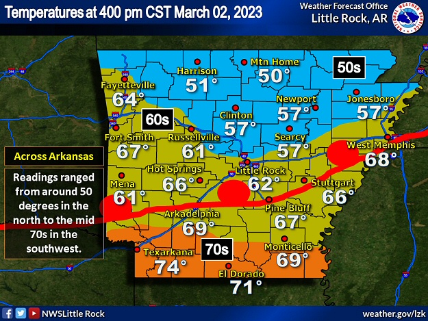 |
| In the picture: As a warm front advanced northward through Arkansas from Louisiana, temperatures climbed well into the 60s and 70s across central and southern sections of the state during the afternoon/evening of 03/02/2023. North of the front, readings were in the 50s. |
|
| |
|
The front on the 1st advanced toward the Louisiana border and stalled. The front was followed by cooler air. On the 2nd, all eyes were on a powerful storm system in the southern Rockies. In response to the approaching system, the front began lifting back to the north. By 400 pm CST, the front cleared the southern counties, and temperatures warmed into the 70s. However, readings north of Little Rock (Pulaski County) were mostly in the 50s.
|
|
|
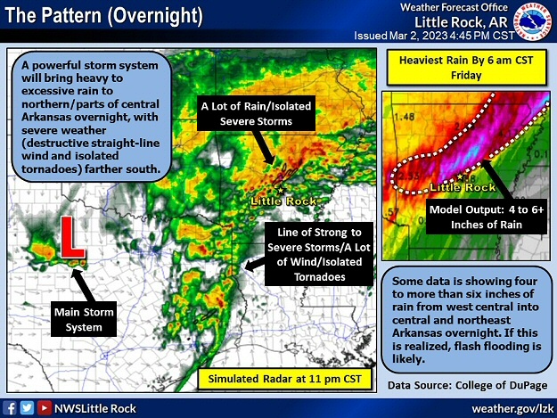
| In the video: The satellite showed a robust storm system (swirling clouds) in New Mexico, with severe thunderstorms developing from central/northeast Texas into southeast Oklahoma during the afternoon of 03/02/2023. |
|
| |
|
As the system neared in the late afternoon, it interacted with the front and round two of thunderstorms commenced from central/northeast Texas into southeast Oklahoma. Eventually, storms congealed into a line and raced toward Arkansas.
|
| Low Pressure Records |
|
As a storm system intensified and moved over Arkansas early on the 3rd, the barometric pressure at Little Rock (Pulaski County) dropped to 29.12 inches at 640 am CST. This was the lowest pressure since 1969 locally, and the fifth lowest pressure on record. At the North Little Rock Airport (Pulaski County), the pressure bottomed out at 29.07 inches at 635 am CST, which was the lowest pressure since data collection began in 1975.
|
 |
| In the picture: As a warm front advanced northward through Arkansas from Louisiana, temperatures climbed well into the 60s and 70s across central and southern sections of the state during the afternoon/evening of 03/02/2023. This is where severe storms were likely (given a warm/unstable environment). North of the front, readings in the 50s were too cool to support much severe weather, but heavy to excessive rain was expected. |
|
| |
|
As the storms progressed into the state after dark, it was clear that severe weather (including tornadoes) was most likely south of the front (in mild air), with mainly heavy to excessive rain farther north (where cooler conditions existed).
Between 900 pm and 1000 pm CST, trees were pushed over by straight-line winds west of Y City (Scott County) and close to De Queen (Sevier County). About this time, rain was coming down in buckets across Scott and Yell Counties, and numerous roads were flooded/about to flood. At Boles (Scott County), there was a report of people surrounded by water and unable to leave their home.
As the night wore on, the Poteau River at Cauthron (Scott County) rose 15 feet in a hurry. The same swollen river swept a pickup truck off of Highway 80 on the east side of Waldron (Scott County). Tragically, the driver (a grandfather trying to visit his grandson) drowned. A traffic camera (provided by the Arkansas Department of Transportation) along Highway 71 south of Boles (Scott County) showed the Fourche La Fave River almost as high as the bridge over the tributary. Eventually, the pavement was inundated and became impassible. As roads turned into lakes, a vehicle stalled at Parks (Scott County), and two individuals were rescued. Similar rescues were ongoing in Yell County, and one person was transported from Corinth to a hospital in Danville (both in Yell County).
|
| An Event Worthy of Attention |
|
Messaging prior to the event on March 2nd/early on the 3rd was more animated/alarming than usual because forecasters had reason to worry. There was a moderate risk of excessive rainfall/flooding across much of northern and central Arkansas according to the Weather Prediction Center (WPC). From central into southwest sections of the state, a convective outlook by the Storm Prediction Center (SPC) had a moderate risk of severe weather (widespread severe storms/potential tornado outbreak).
|
|
|
| |
|
Shortly before 1100 pm CST, a tornado (rated EF2) was spawned just to the north of Kirby (Pike County). A few mobile homes were heavily damaged (resulting in three injuries). One mobile home was rolled and obliterated. Miraculously, two of the four occupants only had minor injuries. Several homes suffered roof damage, and two chicken houses were destroyed.
A couple of hours later, a weak tornado (rated EF0) was confirmed a couple of miles northeast of Tulip (Dallas County). After the tornado dissipated, thunderstorm winds downed/snapped trees along Highway 229 about four miles north of Carthage (Dallas County). A few minutes before 200 am CST on the 3rd, a brief weak tornado (rated EF0) touched down in open fields east of Altheimer (Jefferson County). The tornado took out some trees along Highway 58.
|
| Severe Storm in Dallas County |
|
Early on March 3rd, the WSR-88D (Doppler Weather Radar) showed rotation followed by a debris signature two to three miles northwest of Carthage (Dallas County). This suggested the presence of a tornado. About four miles north of town, rotation weakened significantly, and straight-line wind damage occurred along Highway 229.
|
|
|
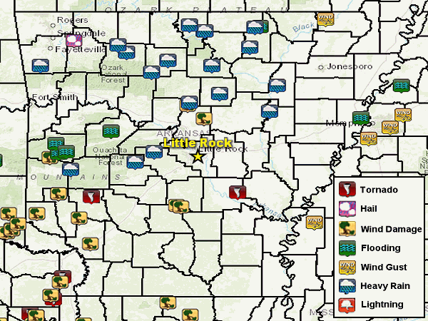
| In the picture: Severe weather, heavy rain, and flood reports on March 2-3, 2023. |
|
| |
|
Elsewhere, a weak tornado (rated EF1) was identified west of Fouke (Miller County). More trees were blown down southwest of Hope (Hempstead County) and northeast of Nashville (Howard County). Wind gusts as high as 70 to 80 mph roughed up barns, outbuildings, and signs between Damascus (Faulkner/Van Buren Counties) and Rose Bud (White County). A recreational vehicle was crushed by a fallen tree at Enola (Faulkner County).
|
|
|
| |
|
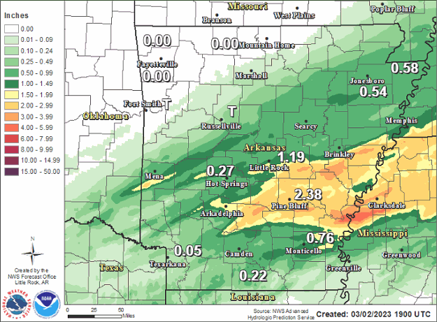
As far as rain, there was a lot of it. Two to more than four inches of rain was common across the northern half of the state in the twenty four hour period ending at 600 am CST on the 3rd. Waldron (Scott County) had 4.90 inches of precipitation, with 4.88 inches at Blue Mountain Dam (Yell County), 4.72 inches at Danville (Yell County), 4.45 inches at Abbott (Scott County), 4.22 inches at Dardanelle (Yell County), 3.87 inches at Booneville (Logan County), 3.70 inches at Mountain View (Stone County), 3.65 inches at Gilbert (Searcy County), 3.57 inches at Calico Rock (Izard County), 3.54 inches at Mena (Polk County), 3.50 inches at Damascus (Van Buren County), 3.47 inches at Marshall (Searcy County) and Morrilton (Conway County), and 3.40 inches at Conway (Faulkner County).
Given so much rain, there was a landslide near the intersection of Highways 103 and 215 west of Oark (Johnson County). Before dawn on the 3rd, the Spring River at Hardy (Sharp County) went up six feet in two hours, was in danger of reaching a level of 14 feet (four feet above the flood stage). As a precaution, folks in homes near the river were asked to evacuate. There was a report of two to three feet of water across streets in a residential area at Marion (Crittenden County).
The rain on the 2nd/early on the 3rd was in addition to the precipitation that fell on the 1st, especially from central into southeast Arkansas. In this part of the state, two or more inches of liquid was measured in places. This included Cane Creek State Park (Lincoln County), Keo (Lonoke County), Marianna (Lee County), Pine Bluff (Jefferson County), Sheridan (Grant County), and Stuttgart (Arkansas County).
|
 |
| In the picture: The hydrograph at Danville (Yell County) showed the Petit Jean River climbing to a stage of 27.22 feet (major flooding) late on 03/03/2023. |
|
| |
|
On the 3rd, there was moderate to major flooding on the Petit Jean River, and minor to moderate flooding on the Black, Cache, Fourche La Fave, Little Red, Ouachita, Saline, Spring, and White Rivers. Concerns were growing that river levels could go even higher if a wet pattern continued into early spring.
|
|
|