|
| Storm Reports |
| Are you interested in what happened during a recent event? Check out the report below. |
|
|
 |
Severe Storms/Turning Colder on January 11-12, 2024 |
 |
| |
|
|
| |
|
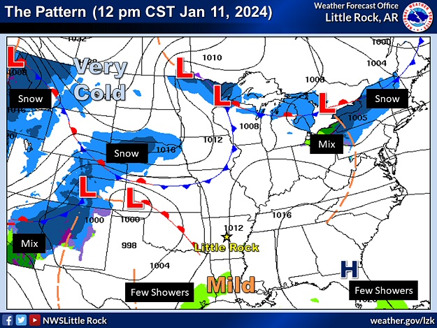
Following a big storm system on January 8th/9th that produced widespread one to two inch rainfall totals, a lot of wind, and snow flurries in northwest Arkansas, a similar system was set to arrive late on the 11th/early on the 12th. The latter system had one more problematic wrinkle than its predecessor, and that was the promise of severe weather.
|
|
|
| In the picture: A Tornado Watch was posted for much of southwest into central Arkansas from 1000 pm CST on 01/11/2024 until 400 am CST the next morning. |
|
| |
|
The wind aloft was very strong (80 mph at 850 millibars or 4,500 feet and 105 mph at 500 millibars or 18,000 feet). It was certain that some of this wind would be transported to the ground by heavy downpours (precipitation drag) in developing thunderstorms (resulting in wind damage). The wind also turned quickly with height (extreme spin potential), which increased the chance of tornadoes. However, because this event was after dark, and there was limited instability (warmth/moisture), this tamed severe storms and kept them from becoming more numerous (prevented an outbreak).
|
| A Lot of Spin/Not Much Instability |
|
At 1200 am CST on the 12th, a sounding (temperature, dewpoint, and wind profile obtained with a balloon launch) at the North Little Rock Airport (Pulaski County) indicated extreme values (800 m2/s2) of helicity (spin potential) in the lowest one kilometer of the atmosphere. However, CAPE (Convective Available Potential Energy/a measure of instability) values were low (only about 350 Joules/kg) given a surface temperature of 58 degrees F and a dewpoint of 56 degrees F.
|
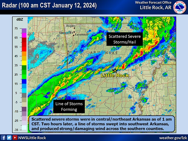 |
Radar at 100 am CST (01/12) | Radar at 300 am CST (01/12)
Radar at 500 am CST (01/12) | Loop |
| In the pictures: The WSR-88D (Doppler Weather Radar) showed scattered severe thunderstorms (producing mainly large hail) in central and northeast Arkansas at 100 am CST on 01/12/2024. Meanwhile, a line of thunderstorms formed to the southwest, and swept across the southern counties during the predawn hours (producing mainly strong to damaging wind). |
|
| |
|
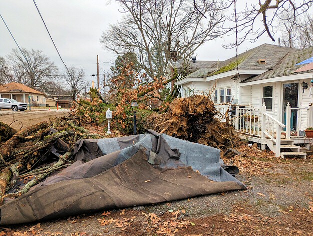
Scattered strong to severe storms started popping up around 800 pm CST on the 11th, and affected mainly central into northeast Arkansas. Spotty wind damage and large hail were noted. During the predawn hours of the 12th, a line of storms developed to the southwest of the state, and swept across the southern counties. These storms were more prolific wind producers. While several Tornado Warnings were issued, including one for the Little Rock (Pulaski County) area between 1200 am and 100 am CST on the 12th, it appears no tornadoes were spawned. Roughly 25,000 utility customers lost power during the event.
|
|
|
| |
|
Trees were downed or snapped by 60 to 80 mph straight line wind at Hampton (Calhoun County), Larue (Benton County), southeast of Magnolia (Columbia County), Malvern (Hot Spring County), Oil Trough (Independence County), Owensville (Saline County), Pleasant Plains (White/Independence Counties), Sheridan (Grant County), south of Snyder (Ashley County), and Tillar (Desha and Drew Counties). Some trees fell on homes. A grain bin was rolled across a highway and into a nearby field near Humphrey (Arkansas/Jefferson Counties). A mobile home was damaged near Harris Brake (Perry County), and part of a roof was removed from a home not far from Marianna (Lee County). A 74 mph gust was measured at Pine Bluff Grider Field (Jefferson County), and a 72 mph gust occurred at the Stuttgart Municipal Airport in Fairmount (Prairie County).
|
|
|
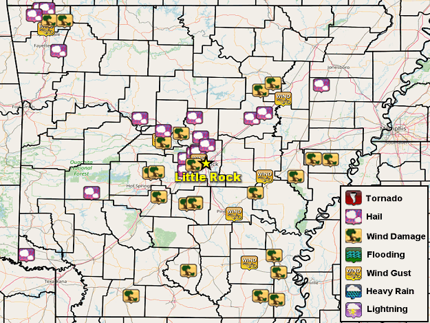
| In the picture: Severe weather reports on January 11-12, 2024. |
|
| |
|
Ping pong ball size hail was reported at Searcy (White County), with half dollar size hail at Maumelle (Pulaski County) and Morgan (Pulaski County), and quarter size hail at Bald Knob (White County), Bay (Craighead County), just north of Caddo Gap (Montgomery County), Cato (Faulkner County), Elkins (Washington County), Foreman (Little River County), Marche (Pulaski County), Oppelo (Conway County), Pottsville (Pope County), not far from Springhill (Saline County), and Weiner (Poinsett County).
|
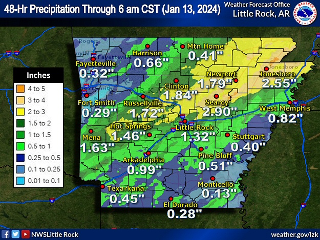 |
| In the picture: Forty eight hour rainfall through 600 am CST on 01/13/2024. |
|
| |
|
The heaviest rain fell from west central into central and northeast sections of the state. One to more than two inch amounts were common in this area in a forty eight hour period ending at 600 am CST on the 13th. Some places had totals over three inches including Augusta (Woodruff County), Beedeville (Jackson County), Greers Ferry Dam (Cleburne County), and Marche (Pulaski County).
|
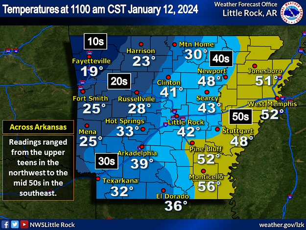 |
| In the picture: There was nearly a forty degree temperature difference across Arkansas at 1100 am CST on 01/12/2024. Readings ranged from the upper teens in the northwest to the mid 50s in the southeast. |
|
| |
|
On the 12th, colder air was ushered into Arkansas from the Plains by a west to northwest wind at 15 to 25 mph and gusts over 40 mph at times. By 300 pm CST, most locations had temperatures in the 20s and 30s, with some upper teens in the northwest. Leftover moisture yielded up to a half inch of snow (a dusting) in the north/west at Greenwood (Sebastian County), Lowell (Benton County), and southeast of Kingston (Madison County).
|
|
|