 |
| Yearly Reports |
| Interested in what kind of weather occurred in a recent year? Check out the most memorable events below. |
|
|
 |
Historic Rain in South Carolina in Early October, 2015 |
 |
| |
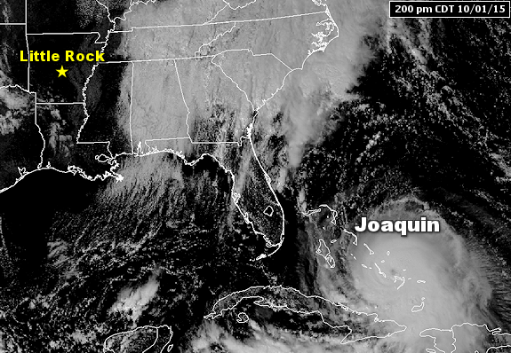 |
| In the picture: Hurricane Joaquin battered the Bahamas at 200 pm CDT on 10/01/2015. |
|
| |
|
While Hurricane Joaquin (a dangerous storm with sustained winds of 145 mph) moved away from the East Coast on October 3rd/4th, parts of the southeast were not out of the woods. In fact, there was a ton of rain falling in South Carolina.
|
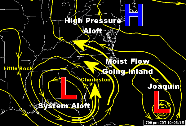 |
| In the picture: Moisture swirling around Hurricane Joaquin and a southeast flow (off the Atlantic Ocean) created by a storm system over the southeast United States led to record rainfall in South Carolina. The latter system was held in place by high pressure to the north, creating a Rex block. |
|
| |
|
That's because a new storm system wobbled into the southeast United States. The system had a hard time going anywhere given high pressure to the north, a pattern called a "Rex block" (named after Dr. Daniel
F. Rex, who identified the pattern in 1950). This led to a persistent flow off the Atlantic Ocean, and a ton of available moisture fed to the system by Joaquin.
|
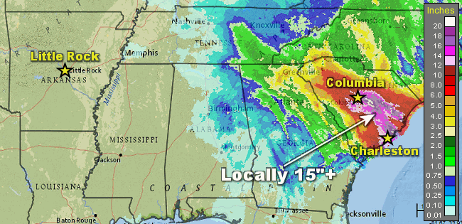 |
| In the picture: Forty eight hour rainfall through 100 am CDT on 10/05/2015. |
|
| |
|
At Charleston, SC, it turned out to be the rainiest day in recorded history on the 3rd. A whopping 11.50 inches was measured, topping the previous record of 10.52 inches on September 21, 1998. The story was about the same the next day at Columbia, SC. Clouds unleashed 6.87 inches of rain on the 4th, which was more than on any day going back 128 years (to June, 1887). It topped the previous mark of 5.79 inches on July 9, 1959. Surrounding these two cities, there were reports of one to two feet of rain in the two-day period.
To put this into perspective, there was more rain in twenty four to forty eight hours in South Carolina than in several months in parts of Arkansas. For example, from July through September (92 days), Little Rock (Pulaski County) got 5.44 inches of rain. There was even less liquid at Texarkana (Miller County) and El Dorado (Union County), with 4.23 inches and 2.62 inches respectively. Normally, 9 to 10 inches should have fallen, which explains why there is a worsening drought locally.
|
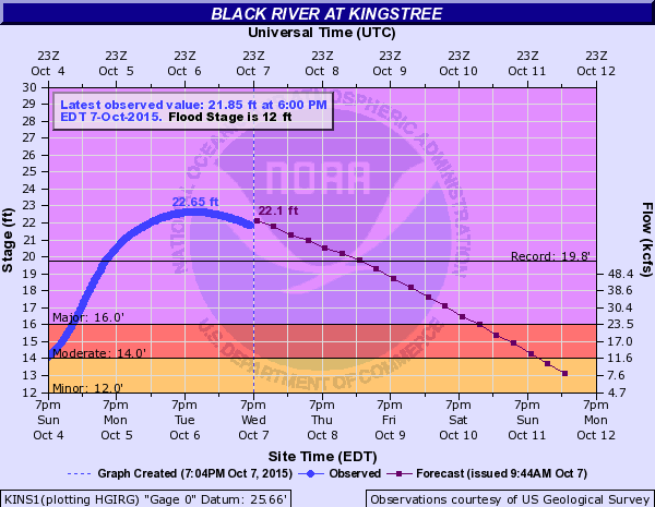 |
| In the picture: A record crest of 22.65 feet was established on the Black River at Kingstree, SC on 10/06/2015. The previous record was 19.8 feet on 06/14/1973. |
|
| |
|
Because of the deluge in South Carolina, Flash Flood Warnings and Emergencies were issued by the National Weather Service. Major to catastrophic flooding occurred (roads flooded and closed, water into homes and businesses, hundreds of high water rescues, etc). Some creeks/small streams rose so quickly that measuring devices/gauges were swept away. A 70 mile section of Interstate 95 was closed between Interstates 20 and 26. A boil order was issued for residents of Columbia, SC due to broken water lines and difficulty in providing clean water. On the northeast side of town, evacuations were ordered as dams/levees failed. At least 17 people lost their lives. The Governor called this a 1-in-1,000-year rain event, with a cost of at least $1 billion.
|
|
|

