|
| Storm Reports |
| Are you interested in what happened during a recent event? Check out the report below. |
|
|
 |
Heavy Rain/Turning Colder on October 26-31, 2023 |
 |
| |
|
|
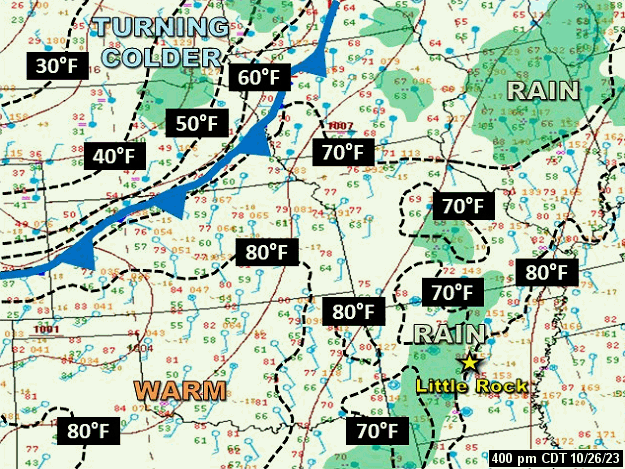
| In the picture: A cold front barreled toward Arkansas from the Plains at 400 pm CDT on 10/26/2023. Isolated to scattered showers were found ahead of the front. While temperatures were warm across Arkansas (lower to mid 80s in parts of the state), much colder air followed the front. |
|
| |
|
Heading into the last days of October, a long awaited heavy rain event unfolded in Arkansas. A significant cold front approached from the Plains on the 26th, and stalled across the region in the days to follow. Warm and moist air to the south of the front flowed over much cooler conditions to the north, and this created clouds and downpours.
|
 |
| Temperatures at 300 pm CDT (10/28) | Radar at 300 pm CDT (10/28) |
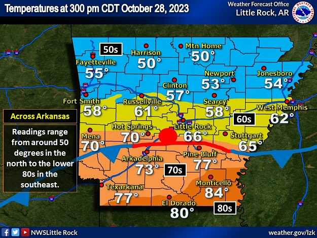
| In the pictures: A front stalled across central Arkansas on 10/28/2023. Temperatures varied more than thirty degrees across the front, ranging from around 50 degrees across the northern counties to the lower 80s in the south. The WSR-88D (Doppler Weather Radar) showed rain developing along and north of the front. |
|
| |
|
By the 28th, the front was parked in central sections of the state. At 300 pm CDT, temperatures ranged from 50 degrees at Harrison (Boone County) and Mountain Home (Baxter County) to 84 degrees at Monticello (Drew County). Widespread rain (and isolated rumbles of thunder) mostly developed along and north of the front. Farther south, any showers were spotty.
|
|
|
| |
|
Overall, the rain was steady and not excessive (flash flooding was localized at most). In the one hundred twenty hour (five day) period ending at 700 am CDT on the 30th, Murfreesboro (Pike County) received 7.95 inches of precipitation, with 6.94 inches at Gilbert (Searcy County), 6.47 inches at Malvern (Hot Spring County), 5.82 inches at Crystal Valley (Pulaski County), 5.45 inches at Alicia (Lawrence County), 5.22 inches at DeGray Lake State Park (Clark/Hot Spring Counties), 5.03 inches at Nashville (Howard County), and 5.00 inches at Marche (Pulaski County). Meanwhile, in the southeast, 0.32 inch of liquid settled the dust at Portland (Ashley County).
While the clouds unleashed a lot of water locally, there was a bona fide deluge in northern Texas. Ten to fifteen inches of rain was measured on the south side of the Dallas-Fort Worth, TX metroplex. Roads and homes were flooded, and people were rescued from high water in Forney, TX and Kaufman, TX. Two residents were killed when their vehicle was swept off the road. Three police officers were injured during rescue operations.
|
|
|
| Drought Conditions (Percent Area) |
| Category |
Coverage |
| None |
23.27% |
| D0-D4 |
76.73% |
| D1-D4 |
44.85% |
| D2-D4 |
27.28% |
| D3-D4 |
2.40% |
| D4 |
0% |
|
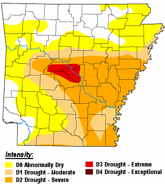
| In the picture: There were moderate to extreme drought (D1 to D3) conditions in central and southern Arkansas on 10/24/2023. |
| |
|
Prior to the rain, severe to extreme drought conditions (D2/D3) existed mainly from central into southeast Arkansas. Six to eight inch rainfall deficits were common at Little Rock (Pulaski County), North Little Rock (Pulaski County), and Pine Bluff (Jefferson County) from July 22nd through October 26th. At the conclusion of this event, drought relief was substantial at the first two locations, but not so much at the latter site (and locations farther southeast).
|
| Precipitation From July 22 to October 26, 2023 |
| Site |
Amount |
Normal |
+/- |
% of Normal |
| Little Rock (C AR) |
3.79 |
10.87 |
-7.08 |
35% |
| North Little Rock (C AR) |
4.21 |
11.68 |
-7.47 |
36% |
| Pine Bluff (SE AR) |
4.79 |
11.53 |
-6.74 |
42% |
|
Earlier in the month, there was another gullywasher, but this was in the southwest and away from where drought was the worst. In the sixty hour period ending at 700 am CDT on the 6th, a few places reported over a half foot of precipitation including Texarkana (Miller County) with 8.19 inches measured.
|
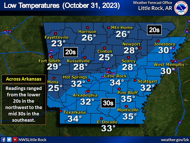 |
| In the picture: At or below freezing temperatures were noted across much of the northern half of Arkansas during the morning of 10/31/2023. Readings stayed above freezing in central and southern sections of the state. |
|
| |
|
As the month ended, the aforementioned front exited toward the Gulf Coast, and temperatures tumbled. By the morning of the 31st, there was a widespread freeze in the northern half of the state, and a freeze here and there across the southern counties. Thermometers showed readings in the lower to mid 20s (a hard freeze) at Clinton (Van Buren County), Compton (Newton County), Fayetteville (Washington County), Harrison (Boone County), Lead Hill (Boone County), Mammoth Spring (Fulton County), Marche (Pulaski County), Marshall (Searcy County), Mena (Polk County), Morrilton (Conway County), Mountain Home (Baxter County), Mountain View (Stone County), Salem (Fulton County), and Waldron (Scott County).
The freeze was right on time to several days late toward the Missouri border, and one to two weeks early in parts of central and southern Arkansas.
|
| Frost and Freeze Information for Arkansas |
| Use the dropdown menu below to find first (Fall) and last (Spring) frost and freeze dates for a location near you. |
SITE: LITTLE ROCK AP ADAMS FLD

FFrost   FFreeze   LFreeze    LFrost
10/31    11/10     03/21      04/03
Please Note: The dates shown are based on climatological normals, with a temperature of 36° for frost and 32° for a freeze. There is at least a 50 percent probability that a first (F) or last (L) Frost/Freeze will occur on these dates. Probabilities go up to 90 percent for a FFrost/FFreeze two weeks later and a LFrost/LFreeze two weeks prior. Probabilities go down to 10 percent for a FFrost/Freeze two weeks prior and a LFrost/LFreeze two weeks later. The dates are courtesy of the National Climatic Data Center.
|
|
|
| This information is based on 1991-2020 normals. |
|
Another freeze occurred to begin November. This one was statewide, and effectively ended the growing season. A few spots in the Ozark Mountains had low temperatures in the upper teens on the 1st.
|
|
|
| In the video: The satellite showed Otis strengthening from a tropical storm to a Category 5 hurricane in only twelve hours late on 10/24/2023. The hurricane made landfall near Acapulco, MX early the next morning (around 125 am CDT) with sustained winds estimated around 165 mph. |
|
| |
|
While this event was not much of a surprise, it came on the heels of another episode that was very much unexpected. Early on the 24th, there were doubts that Tropical Storm Otis would become a hurricane before making landfall along the Pacific Coast of Mexico. As the day progressed, Otis not only attained hurricane status, it grew into a Category 5 storm. Otis moved ashore near Acapulco, MX with sustained winds around 165 mph (satellite estimated)! The aftermath was tragic: extensive damage (likely in the billions of dollars), severed communications, a large scale search for food and water, looting, and a rising death toll.
|
|
|