|
| Storm Reports |
| Are you interested in what happened during a recent event? Check out the report below. |
|
|
 |
Areas of Heavy Rain on July 27-31, 2022 |
 |
| |
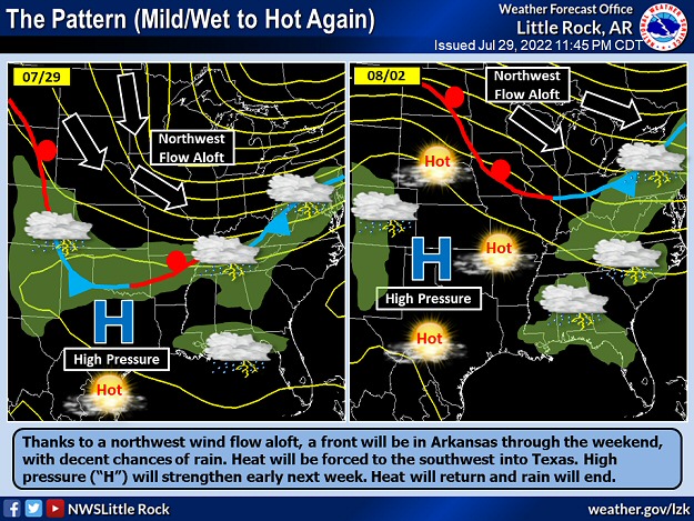 |
| In the picture: High pressure ("H") shifted toward the Gulf Coast in late July, 2022. This allowed a front to push into Arkansas from the northwest, and bring much needed rain and temporarily end a heat wave. The high was expected to strengthen in early August, with heat returning and rain shutting off. |
|
| |
|
The pattern changed temporarily at the end of July. For much of the month, high pressure sat over Arkansas or nearby, and turned up the heat and kept rain spotty. The high shifted toward the Gulf Coast by the 27th, and this allowed a cold front to drift into the state from the north. The front stalled across the region for several days, and was a focus for scattered to numerous showers and thunderstorms.
|
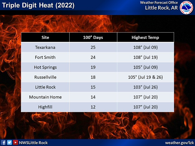 |
| In the picture: Parts of western Arkansas already experienced at least two dozen days of triple digit heat in 2022 through the end of July. |
|
| |
|
Before the downpours started, triple digit readings were commonplace, especially in the west. The mercury hit 100 degrees or more at Texarkana (Miller County) twenty five times in 2022 through July, and twenty four times at Fort Smith (Sebastian County). Preceding the front on the 26th, the high temperature at Fayetteville (Washington County) was 104 degrees, and 105 degrees at Russellville (Pope County). These locations had not experienced such heat since 2012.
|
|
|
|
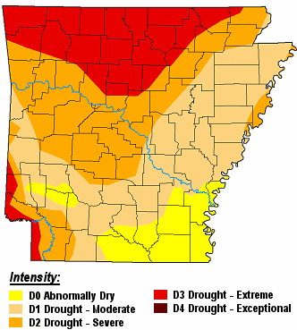
A little more than half of Arkansas had severe drought conditions (D2), and extreme drought conditions (D3) affected almost a quarter of the state. By the 27th, a staggering 72 of 75 counties had burn bans posted.
|
| |
| Drought Conditions (Percent Area) |
| Category |
Coverage |
| None |
0% |
| D0-D4 |
100% |
| D1-D4 |
89.08% |
| D2-D4 |
54.43% |
| D3-D4 |
22.38% |
| D4 |
0% |
|
| In the picture: There were widespread moderate to extreme drought (D1 to D3) conditions across much of Arkansas on 07/26/2022. |
|
|
| In the video: Showers and scattered thunderstorms were noted across the northern half of Arkansas during the predawn hours of 07/29/2022. |
|
| |
|
When the rain finally came, it was most concentrated in areas north of Little Rock (Pulaski County). Many locations in the north received two to more than four inch amounts during this event. At Alicia (Lawrence County), 10.45 inches of precipitation dumped in a four day period ending at 700 am CDT on the 31st. Highfill (Benton County) received 5.24 inches during the same time frame, and Jonesboro (Craighead County) got 4.84 inches. Severe weather was isolated. On the 28th, thunderstorm winds damaged a bank building and blew the press box onto the bleachers at a high school football field at Bismarck (Hot Spring County). Quarter size hail was also reported locally.
|
 |
| In the picture: Seven day rainfall through 7/31/2022. Portions of northern Arkansas had more than five inches of rain, with ten inches or more and extensive flooding in eastern Missouri and eastern Kentucky. |
|
| |
|
Southern and eastern Arkansas also got beneficial rain. In the twenty four hour period ending at 700 am CDT on the 30th, two to three inches of liquid was measured at Cane Creek State Park (Lincoln County) and Crossett (Ashley County). On the 30th, a cloudburst resulted in 3.30 inches of rain at Monticello (Drew County), with 2.81 inches at West Memphis (Crittenden County) on the 31st.
|
| Precipitation in July, 2022 |
| Site |
Amount |
Normal |
+/- |
% of Normal |
| Fayetteville (NW AR) |
2.45 |
3.80 |
-1.35 |
64% |
| Harrison (NC AR) |
3.11 |
3.67 |
-0.56 |
85% |
| Jonesboro (NE AR) |
6.27 |
3.69 |
+2.58 |
170% |
| Fort Smith (WC AR) |
2.06 |
3.39 |
-1.33 |
61% |
| Little Rock (C AR) |
3.22 |
3.33 |
-0.11 |
97% |
| West Memphis (EC AR) |
4.60 |
4.02 |
+0.58 |
114% |
| Texarkana (SW AR) |
0.31 |
3.37 |
-3.06 |
9% |
| El Dorado (SC AR) |
7.38 |
3.43 |
+3.95 |
215% |
| Pine Bluff (SE AR) |
1.15 |
3.69 |
-2.54 |
31% |
|
For the month, most places still had below average precipitation as the event came to a close. There were one to two inch rainfall deficits at Fayetteville (Washington County) and Fort Smith (Sebastian County), and two to more than three inch deficits at Pine Bluff (Jefferson County) and Texarkana (Miller County).
|
| Way Too Much Water |
|
Looking elsewhere, this event was preceded by significant flooding in the St. Louis, MO area. Just over nine inches of rain fell in twenty four hours on July 25th/26th, and this broke the previous record by two inches (set in August, 1915 and due to the remnants of the Galveston Hurricane). Much of the rain (7.68 inches) came down in only six hours, which was faster than it could be carried away. Water flowed into homes and businesses and stalled vehicles. Dozens of people had to be rescued. There were two fatalities. High water closed a thirty mile section of Interstate 70 and damaged the MetroLink light rail transit system.
A couple of days later, there was a deluge in southeast Kentucky, with close to ten inches of rain in places. The North Fork Kentucky River went on a rampage through the rolling terrain of Appalachia. The river reached unprecedented levels at Whitesburg, KY (blowing by the previous record crest in 1957 by six feet) and Jackson, KY. A swollen Troublesome Creek ripped through Fisty, KY and Hindman, KY. As water levels rose, evacuations became necessary, including near an overwhelmed Panbowl Lake Dam at Jackson, KY. Homes were swept off their foundations, and at least fifty bridges were washed away in one county. Thousands of people were displaced. Sadly, at least thirty seven people lost their lives. Adjacent areas of southwest Virginia and southwest West Virginia were also impacted by flooding.
|
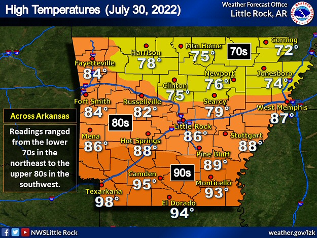 |
| In the picture: High temperatures on 07/30/2022. Readings ranged from the lower 70s in northeast Arkansas to the upper 90s in the southwest. |
|
| |
|
Clouds and rain helped temper the heat. High temperatures on the 30th were only in the 70s in the northeast. This included a 71 degree reading at Walnut Ridge (Lawrence County), and 72 degrees at Corning (Clay County). Unfortunately, it was still hot in the southwest, with mid and upper 90s at Camden (Ouachita County) and Texarkana (Miller County).
|
|
|