|
| Storm Reports |
| Are you interested in what happened during a recent event? Check out the report below. |
|
|
 |
Heavy Rain/Severe Storms on March 23-24, 2023 |
 |
| |
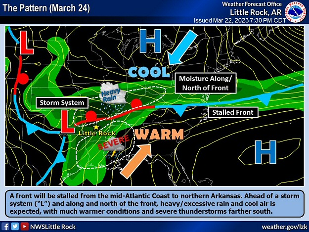 |
| In the picture: A front was stalled across northern Arkansas on 03/24/2023 ahead of an approaching storm system ("L") in the southern Plains. Surrounding the front, areas of heavy rain/flash flooding were expected across the northern half of the state, with severe thunderstorms farther to the south. |
|
| |
|
In the spring, meteorologists watch for big storm systems and colliding warm/moist and cool/dry air masses. If weather maps are showing these features, there may be severe thunderstorms and heavy to excessive rain in the forecast. This is what we were faced with in Arkansas on March 23rd/24th.
During the afternoon of the 23rd, a cold front sagged into northern sections of the state and stalled. Behind the front, temperatures in much of Missouri were in the 40s/50s, with 70s/lower 80s farther south. A storm system was coming together over the southern Plains, and was set to interact with the front. The interaction led to hail producing storms (up to ping pong ball size) from southwest Missouri into far northwest Arkansas and northeast Oklahoma, and three to more than five inches of rain. In the twenty four hour period ending at 700 am CDT on the 24th, Gravette (Benton County) received 3.79 inches of rain, with 3.00 inches at Bentonville (Benton County), and 2.91 inches at Highfill (Benton County).
|
 |
| In the picture: From the Storm Prediction Center (SPC) in Norman, OK, there was an enhanced to moderate risk of severe weather over much of the southeast half of Arkansas on 03/24/2023. |
|
| |
|
It looked a whole lot worse on the 24th. The aforementioned storm system was expected to track across the region, and force contrasting air masses to meet head-on from northwest to southeast. An outbreak of severe weather appeared likely in the late afternoon and evening. On top of that, winds veered sharply from south/southeast near the ground to southwest aloft. The turning of the winds made destructive long track tornadoes possible.
|
 |
| Temperatures/Radar at 1200 pm CDT (03/24) | Satellite at 100 pm CDT (03/24) |
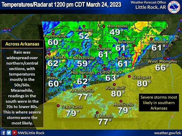
| In the pictures: Rain cooled air (temperatures mostly in the 50s/60s) was found over northern and central Arkansas at 1200 pm CDT on 03/24/2023. The satellite showed lots of clouds over this part of the state. Across the south, there were few clouds and much warmer conditions (temperatures in the 70s to lower 80s), and this is where severe thunderstorms were favored through the early evening. |
|
| |
|
As the morning of the 24th progressed, there was some good news. Rain in northwest Arkansas spread across much of the northern and central counties. As this happened, the environment cooled off and stabilized before the storm system arrived. At 1200 pm CDT, temperatures were in the 50s to lower 60s from Little Rock (Pulaski County) northward, and only 49 degrees at Mountain Home (Baxter County). However, warm readings and an unstable atmosphere remained in the south, and that is where severe storms were still in play.
|
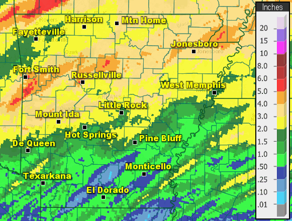 |
| In the picture: Forty eight hour rainfall through 700 am CDT on 03/25/2023. |
|
| |
|
Now for the bad news. As we waited for sparks to fly in the south, downpours became intense from the Ouachita Mountains and the Arkansas River Valley west of Little Rock (Pulaski County) into the northeast. Two to more than four inches of rain dumped, and caused flash flooding in places. Forty eight hour precipitation through 700 am CDT on the 25th included 4.25 inches at Ozone (Johnson County), 3.79 inches at Clarksville (Johnson County), 3.54 inches at Fort Smith (Sebastian County), 3.49 inches at Batesville (Independence County) and Paragould (Greene County), 3.45 inches at Dardanelle (Yell County) and Gilbert (Searcy County), 3.37 inches at Gravelly (Yell County), 3.35 inches at Hattieville (Conway County), Pine Ridge (Montgomery County), and St. Francis (Clay County), 3.22 inches at Booneville (Logan County), 3.20 inches at Newport (Jackson County), and 3.17 inches at the Little Rock Air Force Base (Pulaski County).
Too much rain caused flooding along Highway 80 west of Waldron (Scott County), and the highway had to be closed. Highway 22 near Barling (Sebastian County) was covered by water. The Petit Jean River at Booneville (Logan County) rose sixteen feet in a hurry, and overflowed its banks. Multiple roads turned into lakes in Johnson County, a few bridges were submerged, and water flowed into at least one home. Streets were flooded at Bald Knob (White County), Cabot (Lonoke County), on the north side of Hot Springs (Garland County), the Little Rock (Pulaski County) area, Pine Bluff (Jefferson County), and Russellville (Pope County).
Five miles northwest of Paron (Saline County), a 68-year-old man on a motorcycle apparently tried to cross a road at the Lake Winona spillway. He was swept off the pavement and down the Alum Fork Saline River where he drowned. At Beebe (White County), a child was pulled into a drainage culvert and got stuck. He was rescued and taken to the nearest hospital.
|
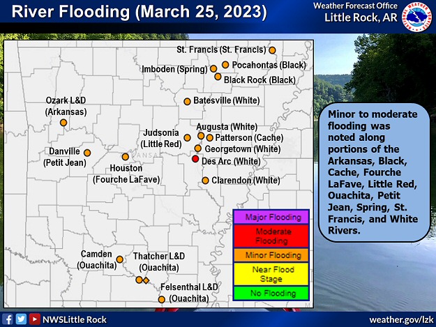 |
| In the picture: Minor to moderate flooding was noted along the Black, Cache, Fourche LaFave, Little Red, Ouachita, Petit Jean, Spring, St. Francis, and White Rivers on 03/25/2023. |
|
| |
|
Tributaries remained elevated, and in some cases went higher due to the rain. There was minor to moderate flooding along portions of the Arkansas, Black, Cache, Fourche LaFave, Little Red, Ouachita, Petit Jean, Spring, St. Francis, and White Rivers.
|
|
|
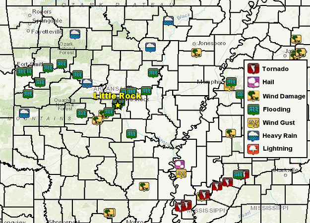
| In the picture: Severe weather, heavy rain, and flood reports on March 24, 2023. |
|
| |
|
The rain/flooding ended up being the main impact of this event. Luckily, while strong to severe storms popped up, they were isolated. Strong to damaging straight-line winds downed trees at Benton (Saline County), Glen Rose (Hot Spring County), east of Greenfield (Poinsett County), east of Hamburg (Ashley County), and in parts of White County. At Benton (Saline County), the trees fell on two homes.
|
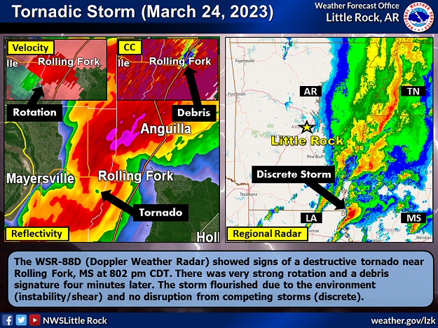 |
| In the picture: The WSR-88D (Doppler Weather Radar) showed signs of a destructive tornado near Rolling Fork, MS at 802 pm CDT on 03/24/2023. There was very strong rotation and a debris signature four minutes later. The storm flourished due to the environment (instability/shear) and no disruption from competing storms (discrete). |
|
| |
|
The horror of this event was realized around 800 pm CDT less than twenty miles away from the southeast corner of Arkansas. Just across the Mississippi River in western Mississippi, a discrete supercell (storm with rotating updrafts) spawned a monster tornado (rated EF4/170 mph peak wind). Nationwide (and here at home), tornadoes of this magnitude are very rare (occurring less than one percent of the time), and eight out of ten tornadoes are weak (rated EF0/EF1).
|
| Tornadoes in Arkansas (2000 to 2022) |
| Rating |
How Many |
Percent of Total |
| F0/EF0 |
292 |
33% |
| F1/EF1 |
445 |
50% |
| F2/EF2 |
117 |
13% |
| F3/EF3 |
26 |
3% |
| F4/EF4 |
4 |
<1% |
| F5/EF5 |
0 |
0% |
| Note: A total of 891 tornadoes were spawned. Seven tornadoes (less than 1% of the total) were rated EFU ("U" is unknown) because there was no damage to evaluate. |
|
|
| In the video: A tornado (rated EF4) obliterated much of Rolling Fork, MS during the evening of 03/24/2023. The scope of the damage was realized at first light the next morning. The video is courtesy of Aaron Rigsby via Twitter. |
|
| |
|
The tornado cut an almost sixty mile swath through Rolling Fork, Silver City, and Tchula. Structures were steamrolled, trees were debarked, and vehicles were tossed. Sadly, the tornado was responsible for at least seventeen fatalities. Farther northeast, the same supercell cranked out a couple more tornadoes (both rated EF3/155 mph peak wind) that carved out twenty nine mile and thirty seven mile paths through Winona, Amory, and Smithville. Five people were killed (a total of twenty two deaths in Mississippi).
|
|
|