| |
Temperatures |
Precipitation |
| Site |
Max |
Min |
Avg |
Norm |
Dep |
Hi |
Lo |
Sum |
Norm |
Dep |
| Fayetteville (NW AR) |
74.5 |
44.6 |
59.5 |
58.0 |
+1.5 |
88 |
22 |
3.21 |
4.48 |
-1.27 |
| Harrison (NC AR) |
72.0 |
47.1 |
59.5 |
59.4 |
+0.1 |
85 |
27 |
4.31 |
3.81 |
+0.50 |
| Jonesboro (NE AR) |
74.3 |
49.5 |
61.9 |
62.2 |
-0.3 |
85 |
31 |
2.29 |
3.81 |
-1.52 |
| Fort Smith (WC AR) |
77.6 |
50.8 |
64.2 |
63.5 |
+0.7 |
93 |
30 |
6.28 |
4.42 |
+1.86 |
| Little Rock (C AR) |
78.6 |
52.1 |
65.4 |
62.6 |
+2.8 |
92 |
33 |
2.22 |
4.47 |
-2.25 |
| Texarkana (SW AR) |
79.9 |
54.9 |
67.4 |
65.0 |
+2.4 |
91 |
36 |
1.48 |
4.38 |
-2.90 |
| El Dorado (SC AR) |
78.1 |
48.5 |
63.3 |
64.7 |
-1.4 |
89 |
28 |
3.94 |
4.45 |
-0.51 |
| Pine Bluff (SE AR) |
78.9 |
51.0 |
64.9 |
63.7 |
+1.2 |
92 |
31 |
2.02 |
4.58 |
-2.56 |
With the exception of a few locations, above normal temperatures were common across the state in October. Rainfall amounts came up short across much of the state, but a few reporting sites picked up above normal totals which was uncommon over the past few months.
| |
| Temperature records broken in October. Check out the records below. |
| Site |
Record Low (Date of Occurrence) |
| Little Rock |
33T (10/19) |
| North Little Rock |
33 (10/19) |
| Jacksonville/LRAFB |
32 (10/18), 28 (10/19), 30 (10/20) |
| Batesville |
29T (10/19), 31 (10/20) |
| Mount Ida |
101 (9/21), 99 (9/24) |
| Stuttgart |
34 (10/18), 29 (10/19), 35 (10/20) |
| Russellville |
28 (10/19) |
| Hot Springs |
35 (10/18), 31 (10/19) |
| Monticello |
29 (10/19) |
October brought quite a bit of change across the state and even with temperatures generally above normal and rainfall amounts generally below normal, improvements to the ongoing drought and prolonged period of above normal temperatures were noticeable. Even with monthly average temperatures turning out to be above normal at most locations, several record low temperatures were recorded along with some unusually early freezing temperatures in places.
|
|
| In the picture: A chart that displays record low values along the Mississippi and Ohio Rivers. |
Warming temperatures were observed at the start of the month along with dry conditions, continuing a dry streak from late September. Overnight lows were cool, but daytime highs began climbing to above average levels by Oct 2-3. Temperatures reached 90 degrees at several locations on the 6th before a cold front moved through bringing cooler temperatures by the 7th/8th.
Given the persistent, worsening drought conditions, barge traffic along the Mississippi River had been significantly reduced or closed down entirely. In some cases, harvested crops were kept in dry storage until water levels rise.
Temperatures began to moderate once again by the 10th with moisture starting to increase ahead of an approaching storm system. A few showers developed across far western Arkansas on the 10th. More rain occurred on the 11th with a cold front moving across the state on Wednesday, the 12th. Rainfall amounts weren’t significant, but some spots picked up over one half inch. Several strong to severe storms occurred, with a few producing one inch hail. Slightly cooler temperatures occurred behind the front along with much drier air. Wildfire danger rose to the extreme level according to the Arkansas Forestry Division with Red Flag Warnings being issued across the northern half of the state on the 13th and 14th.
As temperatures warmed into the 80s/lower 90s on Saturday October 15th, a cold front approached from the north. Thunderstorms developed from the afternoon into the evening hours from near Fort Smith to Little Rock to Memphis. Several reports of hail were received with some of the severe storms. The largest hail occurred in Olyphant (Jackson County) where 3 inch hail fell. Rain and thunderstorms became more widespread overnight into Sunday morning October 16th with much of the state seeing over one half inch. Portions of S/SE Arkansas saw little to no rain. The heaviest amounts occurred along and south of the AR River Valley from Fort Smith to Russellville.
Much drier and colder air moved in behind the front with well below normal temperatures seen through October 19-20. A freeze occurred across N AR Tuesday morning October 18th with more widespread below freezing temperatures statewide for the morning of October 19th.
After cool mornings across the state from Oct 18-20, temperatures quickly rebounded to well above normal values. Highs from Oct 21-24 were in the 70s to mid 80s with windy conditions. A storm system approached by the 24th and brought widespread rain to western Arkansas through the 25th. Some amounts were as high as 3 inches. The storm system moved across the state on the 25th with rainfall amounts much less across the eastern half of the state. Winds were very strong and temperatures fell throughout the day.
Comfortable temperatures were in place to end the month with some additional and very beneficial rain occurring from October 28-30. The highest amounts occurred across western Arkansas over the Ouachita Mountains. A pleasant evening was noted for trick or treaters across the state on Halloween with dry conditions and temperatures in the 50s/60s.
| Temperature and Precipitation Trends |
| |
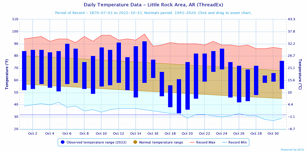 |
| In the picture: Temperatures at Little Rock (Pulaski County). Click to enlarge. |
|
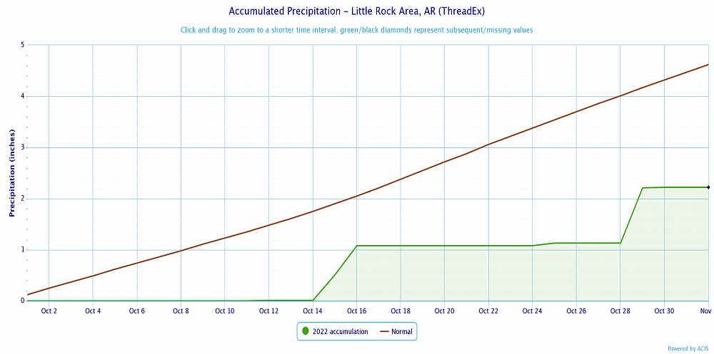 |
| In the picture: Precipitation at Little Rock (Pulaski County). Click to enlarge. |
|
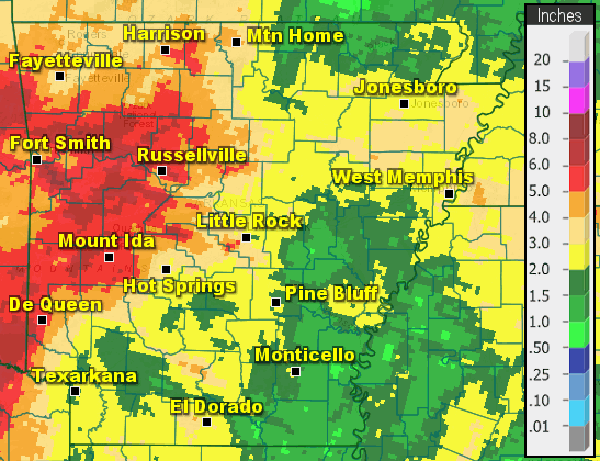 |
| In the picture: Precipitation across Arkansas. |
|
|


