| |
Temperatures |
Precipitation |
| Site |
Max |
Min |
Avg |
Norm |
Dep |
Hi |
Lo |
Sum |
Norm |
Dep |
| Fayetteville (NW AR) |
91.0 |
69.2 |
80.1 |
77.9 |
+2.2 |
97 |
60 |
4.95 |
3.80 |
+1.15 |
| Harrison (NC AR) |
89.6 |
68.4 |
79.0 |
78.5 |
+0.5 |
96 |
58 |
4.55 |
3.67 |
+0.88 |
| Jonesboro (NE AR) |
89.8 |
72.0 |
80.9 |
81.7 |
-0.8 |
97 |
62 |
8.67 |
3.69 |
+4.98 |
| Fort Smith (WC AR) |
94.4 |
73.8 |
84.1 |
83.1 |
+1.0 |
102 |
68 |
5.90 |
3.39 |
+2.51 |
| Little Rock (C AR) |
92.8 |
74.3 |
83.6 |
81.4 |
+2.2 |
102 |
67 |
3.71 |
3.33 |
+0.38 |
| Texarkana (SW AR) |
96.1 |
76.8 |
86.4 |
82.4 |
+4.0 |
103 |
70 |
3.33 |
3.24 |
+0.09 |
| El Dorado (SC AR) |
92.1 |
72.3 |
82.2 |
82.5 |
-0.3 |
99 |
66 |
6.91 |
3.32 |
+3.59 |
| Pine Bluff (SE AR) |
93.3 |
74.4 |
83.9 |
81.9 |
+2.0 |
101 |
67 |
1.70 |
3.69 |
-1.99 |
Temperatures were generally above average. Precipitation was generally above average, especially across portions of northeast and southern Arkansas.
| |
| Temperature records broken in July. Check out the records below. |
| Site |
Record High (Date of Occurrence) |
| Batesville |
100 (7/12) |
| Site |
Record Low (Date of Occurrence) |
| North Little Rock |
67T (7/9), 65 (7/10), 66T (7/11) |
 |
| In the picture: A ridge of high pressure ("H") mostly stayed to the west during the first three weeks of July, 2023, allowing cold fronts to sweep into Arkansas from the Plains. The fronts triggered scattered showers and thunderstorms, and kept temperatures from getting too hot. The high eventually took over during the last week of the month, and heat became oppressive. |
|
| |
|
Oppressive heat was a theme in much of Arkansas in July, but not until late in the month. The ridge of high pressure responsible for the heat resided just to our southwest, and produced unprecedented hot temperatures in places. At Phoenix, AZ, the mercury reached at least 110 degrees on a record thirty one days straight ending on the 30th (crushing the previous record of eighteen days in June, 1974), and there was not a drop of rain. It was the hottest month on record for any city in the United States! Here at home, as high pressure stayed away, cold fronts moved around the periphery of the high and brought scattered strong to severe thunderstorms.
|
|
|
| In the picture: There were reports of wind damage, large hail, flash flooding, and isolated tornadoes from July 1-21, 2023. |
|
| |
|
While there were not any outbreaks of severe weather, there were significant reports of hail, damaging wind, and flash flooding. The month got off to a quick start with golf ball size hail just east of Omaha (Boone County) on the 1st. On the 5th, there was a 62 mph wind gust measured at Newport (Jackson County). Almost three inches of rain dumped in Monticello (Drew County) on the 6th, and high water flowed across Highway 278. The road had to be closed temporarily. It was the same story at Greenbrier (Faulkner County), with numerous roads under water.
|
|
|
| In the picture: Heavy rain and flash flooding were huge concerns on 07/12/2023. |
|
| |
|
It got more serious early on the 12th. There was heavy rain in the forecast, and flash flooding was a big concern in southwest Arkansas.
|
|
|
| In the picture: Twenty four hour rainfall through 700 am CDT on 07/12/2023. |
|
| |
|
Parts of the southwest received over six inches of rain, including an unofficial report of 12.77 inches of precipitation a few miles north of Waldo (Columbia County). Just southwest of Patmos (Hempstead County) 7.23 inches of liquid was measured. Flooding of roads/highway closures occurred from Hope (Hempstead County) to El Dorado (Union County) and Hamburg (Ashley County). Trees were uprooted or snapped just south of Stamps (Lafayette County). A weak tornado (rated EF1) was responsible for the damage.
The next morning, a similar deluge was experienced in Mississippi. At least a foot of rain dumped to the northeast of Louisville, MS, and resulted in significant high water issues.
In northwest Arkansas, thunderstorms unleashed 63 mph gusts at Fayetteville (Washington County) and Highfill (Benton County) on the 13th.
|
|
|
| In the video: The WSR-88D (Doppler Weather Radar) showed a line of strong to severe thunderstorms surging into Arkansas from the northwest during the nighttime hours of 07/14/2023. |
|
| |
|
Perhaps the most impactful severe weather in July spread from northwest into central and southeast sections of the state on the 14th/15th. Thunderstorm wind gusts topped out at 74 mph in Fort Smith (Sebastian County). Numerous trees were downed in and around the city, with some trees on houses. Torrential rain flooded homes and stalled vehicles. Multiple people had to be rescued. Two to more than three inches of rain fell from Fort Smith (Sebastian County) to Waldron (Scott County) and Mena (Polk County). A weak tornado (rated EF1) was confirmed on the south side of Mansfield (Sebastian County).
Elsewhere, Fayetteville (Washington County) had another big gust (67 mph), and Little Rock National Airport (Pulaski County) was not far behind (58 mph). A tree fell on a camping vehicle at Diamond City (Boone County), and a barn was overturned near Whiteville (Baxter County). Trees were toppled near Fairview (Ouachita County), and downed trees blocked roads at Lake Village (Chicot County).
During the afternoon of the 16th, a lot of trees were pushed over along the Louisiana border from Texarkana (Miller County) to El Dorado (Union County). There were spotty instances of hail/damaging wind across the northern and central counties on the 17th/18th, and also on the 21st.
|
|
|
| In the pictures: Smoke from Canadian wildfires created unhealthy air quality from the upper Midwest into the Great Lakes, Ohio and Tennessee Valleys, and New England in mid-July, 2023. The information is courtesy of the National Weather Service in Lincoln, IL via Twitter. |
|
| |
|
While we dealt with active weather, our neighbors to the north/east faced an entirely different problem. Smoke from Canadian wildfires poured into the upper Midwest, Great Lakes, Ohio and Tennessee Valleys, and New England. While the air quality went downhill, it was not as unhealthy as what was experienced in June (thicker smoke). The highest Air Quality Index (on a scale from 0 or "good" to 500 or "hazardous") readings were between 100 and 200, which was well below values close to 400 along the East Coast in the previous month.
|
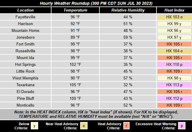 |
| In the table: Oppressive conditions were noted across much of Arkansas (except in north/northeast sections of the state) on 07/30/2023. Temperatures were well into the 90s, with readings in the triple digits at a few spots. Heat indices were between 100 and 115 degrees. |
|
| |
|
Back in Arkansas, the temperature failed to reach 95 degrees at Little Rock (Pulaski County) through the 17th. That was before the aforementioned ridge of high pressure strengthened and built overhead. From the 18th through the 31st, the thermometer showed at least 95 degrees on ten of fourteen days, and hit the century mark (100 degrees or more) twice. The heat index became dangerous (over 105 degrees) across much of the region (except for the Ozark/Ouachita Mountains), and Heat Advisories became common.
|
|
|
| Storm Reports (07/28) | Storm Reports (07/29) |
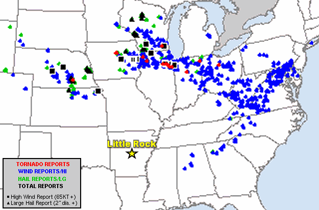
| In the pictures: There were numerous reports of severe weather from the central Plains and western Great Lakes to the mid-Atlantic states and the northeast on July 28-29, 2023. |
|
| |
|
As the month came to a close, high pressure wobbled toward the Rockies, and clusters of thunderstorms visited once again. On the 28th/29th, the storms were not far away, and cranked out a lot of wind from the central Plains and western Great Lakes to the mid-Atlantic states and the northeast. The storms rolled through cities such as Charleston, WV, Chicago, IL, Dayton, OH, St. Louis, MO, and Washington, DC.
|
|
|
| In the video: The satellite showed high pressure providing a mostly clear sky/dry conditions in the southern Plains after dark on 07/30/2023. Around the periphery of the high, thunderstorms rode a northwest flow into Arkansas from Kansas and Missouri. |
|
| |
|
Severe weather made it into places near the Missouri border during the evening of the 29th. Trees were flattened at Ash Flat (Sharp County), Black Rock (Lawrence County), and Gamaliel (Baxter County). Early on the 31st, power outages were widespread in Boone and Marion Counties (due to lightning and wind). A shed was destroyed at Damascus (Van Buren County).
|
| Temperature and Precipitation Trends |
| |
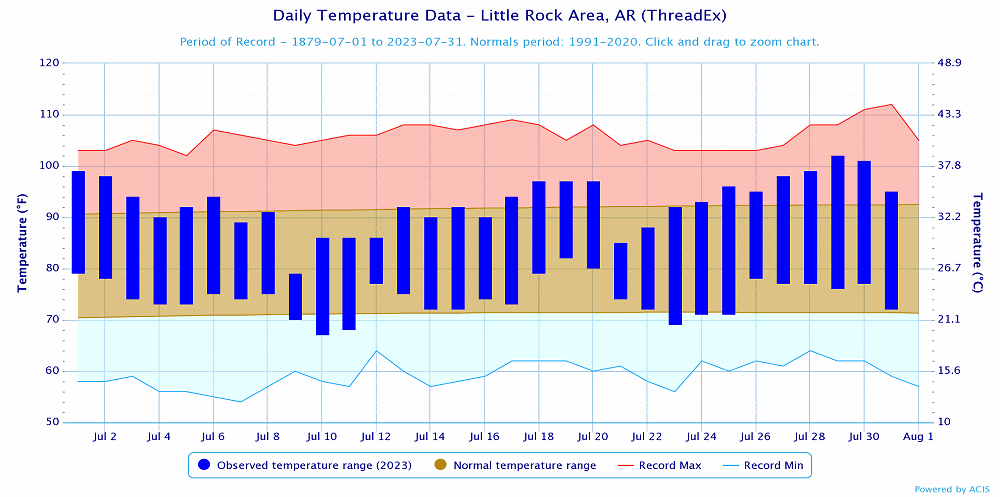 |
| In the picture: Temperatures at Little Rock (Pulaski County). Click to enlarge. |
|
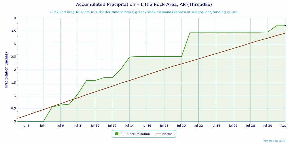 |
| In the picture: Precipitation at Little Rock (Pulaski County). Click to enlarge. |
|
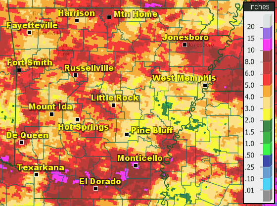 |
| In the picture: Precipitation across Arkansas. |
|
|