 |
| Storm Reports |
| Are you interested in what happened during a recent event? Check out the report below. |
|
|
 |
Helene Brings Heavy Rain/Gusty Wind on September 27, 2024 |
 |
| |
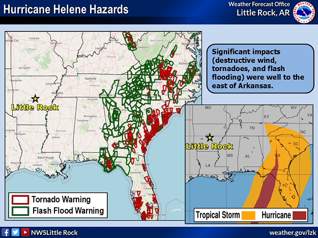 |
| In the picture: Hurricane Helene pummeled the southeast United States with destructive wind, tornadoes, and widespread flash flooding in late September, 2024. These hazards were well east of Arkansas. |
|
| |
|
The tropics were active in late September, and powerful Hurricane Helene hit the southeast United States with destructive wind (especially Florida into Georgia), devastating flash flooding (especially Georgia into eastern Tennessee and the western Carolinas), record storm surge (Florida Gulf Coast), and isolated tornadoes. Power outages topped three million.
|
|
|
| In the video: Hurricane Helene made landfall along the Florida Gulf Coast (10 miles southwest of Perry, FL) at 1010 pm CDT on 09/26/2024. Maximum sustained winds were around 140 mph (making Helene a Category 4 storm). |
|
| |
|
Hurricane Helene blasted into the Gulf Coast of Florida (about ten miles southwest of Perry, FL) as a Category 4 storm (140 mph sustained winds) during the late evening of the 26th. A fast movement (north-northeast at 20 to 25 mph) carried hurricane force gusts well inland. The system arrived close to high tide, and the storm surge may have exceeded 15 feet (extreme flooding) in the Big Bend region of Florida. Record storm surge (just over 9 feet) was observed in places like Cedar Key, FL.
|
 |
| Weather Pattern | Simulated Radar |
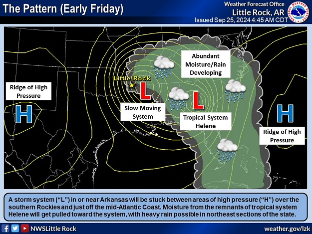
| In the pictures: The remnants of Hurricane Helene interacted with a storm system just to the east of Arkansas on 09/27/2024. Moisture was pulled westward, and rain spread over northern, central, and eastern sections of the state. |
|
| |
|
As the remnants of Helene tracked westward through the Tennessee Valley, there was some interaction with a storm system just to the east of Arkansas. Moisture was pulled toward the system, and rain spread over the northeast half of the state on the 27th. Several sites in the northeast had amounts over two inches.
|
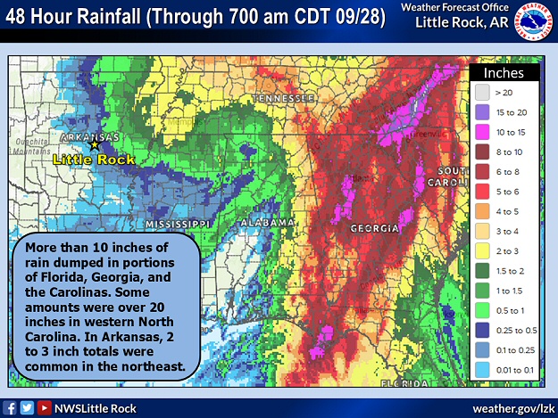 |
| In the picture: Forty eight hour rainfall through 700 am CDT on 09/28/2024. |
|
| |
|
In the forty eight hour period ending at 700 am CDT on the 28th, Saint Francis (Clay County) received 2.81 inches of rain, with 2.33 inches at West Memphis (Crittenden County), 2.12 inches at Beedeville (Jackson County), 2.10 inches at Paragould (Greene County), and 2.00 inches at Black Rock (Lawrence County). The rain was accompanied by breezy northwest winds, and 30 to 40 mph gusts at times.
Overall, it was a low impact event in Arkansas, and a far cry from what was experienced 350 to 450 miles to the east. Up to 30 inches of rain in the mountains of North Carolina qualified as a 1 in 1,000 year deluge. At one point, officials told residents to consider all roads closed in that area of the state (including Interstates 26 and 40), and the Governor declared Helene as one of the worst storms in modern history locally.
|
|
|

