|
| Storm Reports |
| Are you interested in what happened during a recent event? Check out the report below. |
|
|
 |
Francine Brings Heavy Rain/Gusty Wind on September 11-16, 2024 |
 |
| |
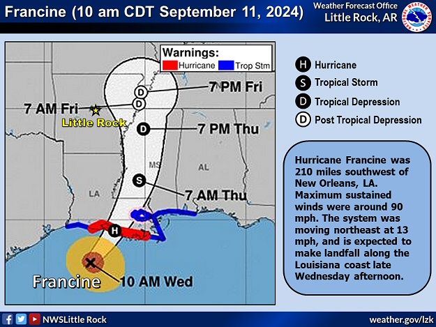 |
| In the picture: Hurricane Francine was closing in on the Louisiana Gulf Coast on 09/11/2024. The system briefly became a category two storm (maximum sustained wind around 100 mph) before making landfall during the late afternoon. The remnants of Francine eventually unleashed areas of heavy rain in parts of Arkansas (in the southwest and east) as well as wind gusts up to 50 mph (in the east). |
|
| |
|
Arkansas was in need of rain as September began, and the tropics came to the rescue. Hurricane Francine made landfall along the Louisiana Gulf Coast on the 11th, and headed northward through Mississippi.
|
|
|
| In the video: The WSR-88D (Doppler Weather Radar) showed areas of heavy rain spreading into Arkansas from the remnants of Hurricane Francine on September 11-12, 2024. |
|
| |
|
Along the way, areas of heavy rain spread across parts of the southwest and east, with widespread amounts over two inches. Several locations received more than four inches of precipitation.
|
|
|
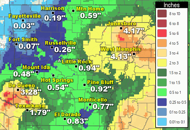
| In the picture: Forty eight hour rainfall through 700 am CDT on 09/13/2024. |
|
| |
|
In the forty eight hour period ending at 700 am CDT on the 13th, 6.55 inches of rain was measured at Foreman (Little River County), with 6.20 inches near Harrisburg (Poinsett County), 5.44 inches at Millwood Dam (Little River County), 4.17 inches at Jonesboro (Craighead County), and 4.13 inches at West Memphis (Crittenden County).
|
|
|
|
Given ongoing drought conditions in Arkansas, much of the rain soaked into the ground, and no flash flooding occurred.
|
| |
| Drought Conditions (Percent Area) |
| Category |
Coverage |
| None |
14.38% |
| D0-D4 |
85.62% |
| D1-D4 |
38.50% |
| D2-D4 |
3.66% |
| D3-D4 |
0% |
| D4 |
0% |
|
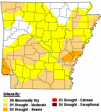
| In the picture: There were moderate to severe drought (D1/D2) conditions in parts of southern, central, and eastern Arkansas as well as the far northwest on 09/10/2024. |
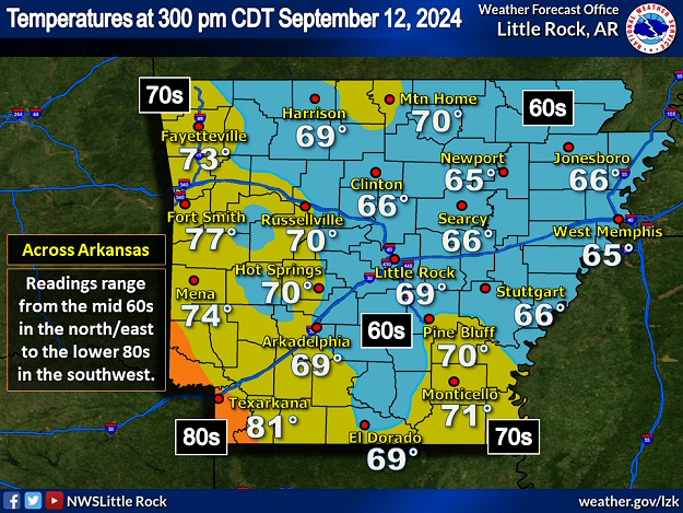 |
| In the picture: Temperatures at 300 pm CDT on 09/12/2024 ranged from the mid 60s in northern and eastern Arkansas to the lower 80s in the southwest. |
|
| |
|
Clouds and rain on the 12th kept temperatures cool. At 300 pm CDT, multiple sites in northern/eastern sections of the state had readings only in the mid 60s (up to twenty degrees below average). Meanwhile, wind speeds picked up in the northeast as the remnants of Francine neared the region. A 50 mph gust was reported at Jonesboro (Craighead County), with a 45 mph gust at Blytheville (Mississippi County), a 43 mph gust at West Memphis (Crittenden County), and a 40 mph gust at Newport (Jackson County). Trees were downed at Marked Tree (Poinsett County), Marmaduke (Greene County), and Parkin (Cross County). One tree fell on a home in Weiner (Poinsett County), and power lines were downed in places.
|
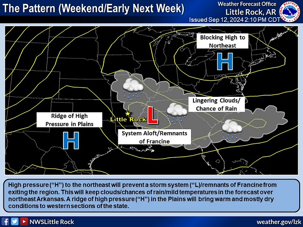 |
| Blocking Pattern | 120 Hour Rainfall Through 700 am CDT (09/16) |
| In the pictures: Strong high pressure ("H") to the northeast blocked the forward progress of the remnants of Hurricane Francine ("L") in mid-September, 2024. This kept clouds, chances of showers, and mild temperatures in the forecast across Arkansas for several days. Event rainfall (five day period) topped six inches in the northeast. |
|
| |
|
On the 13th, the remnants of Francine were in no hurry to exit the area. A blocking pattern set up (in this case a Rex block/high pressure to the north of low pressure), with a promise of clouds, chances of showers, and mild temperatures for several days. Through the morning of the 16th (a seventy two hour period), another two to more than three inches of rain came down in the northeast at Batesville (Independence County), Corning (Clay County), Heber Springs (Cleburne County), Jonesboro (Craighead County), Marianna (Lee County), Paragould (Greene County), and Saint Francis (Clay County). For the event (five days), totals exceeded six inches in portions of Clay, Craighead, Crittenden, Cross, Greene, Lee, Little River, Mississippi, and Poinsett Counties.
|
|
|