 |
| Storm Reports |
| Are you interested in what happened during a recent event? Check out the report below. |
|
|
 |
August, 2020 Storm Report |
 |
| |
| Short Weather Summary |
| |
| August will be remembered for way too much rain and flooding in western Arkansas. Farther east, it was dry for awhile, but that was changed by the remnants of Hurricane Laura. In addition to a lot of precipitation, Laura brought gusty winds and isolated tornadoes as well. While it was hot at times, it did not last long. Temperatures were mild more often than not. |
| |
| There were a few record low temperatures tied or broken in early August. Check out the record below. |
| Site |
Record Low (Date of Occurrence) |
| North Little Rock |
64 (08/05), 63T (08/06) |
| Stuttgart |
64 (08/05) |
| Note: "T" means record was tied. |
| Very Wet in the West/Hurricane Laura Visits/Mild Overall |
| |
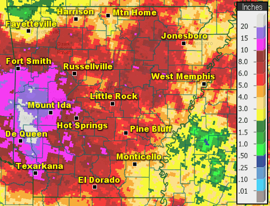 |
| In the picture: Rainfall in August, 2020. |
|
| |
|
It was ridiculously wet across western Arkansas in August, 2020. Ten to more than twenty inches of rain fell from around Fort Smith (Sebastian County) southward through the Ouachita Mountains and on toward Texarkana (Miller County).
Interestingly, while parts of the west got over four times the normal monthly rainfall, it was dry in the northwest. At Fayetteville (Washington County), there was only 1.14 inches of precipitation (2.10 inches below average).
|
| Precipitation in August, 2020 |
| Site |
Amount |
Normal |
+/- |
% of Normal |
| Fayetteville (NW AR) |
1.14 |
3.24 |
-2.10 |
35% |
| Harrison (NC AR) |
4.37 |
3.58 |
+0.79 |
122% |
| Jonesboro (NE AR) |
6.19 |
2.54 |
+3.65 |
244% |
| Fort Smith (WC AR) |
9.98 |
2.59 |
+7.39 |
385% |
| Little Rock (C AR) |
6.02 |
2.59 |
+3.43 |
232% |
| West Memphis (EC AR) |
3.39 |
3.06 |
+0.33 |
111% |
| Texarkana (SW AR) |
13.11 |
2.91 |
+10.20 |
451% |
| El Dorado (SC AR) |
4.86 |
3.11 |
+1.75 |
156% |
| Pine Bluff (SE AR) |
4.90 |
2.48 |
+2.42 |
198% |
|
|
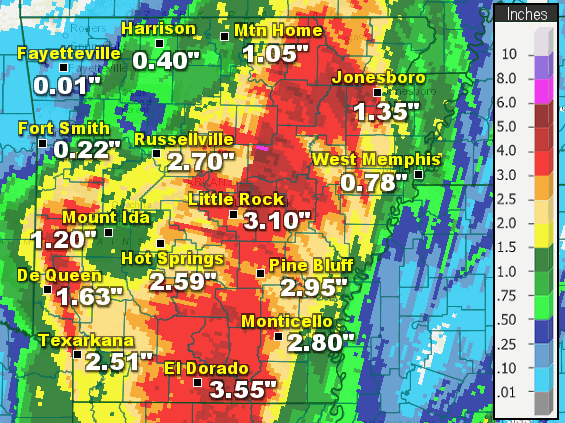
| In the table: Following the rain on 08/31/2020, it was the wettest August on record at almost a dozen sites in western Arkansas. |
|
| |
|
It was the wettest August on record at almost a dozen sites in the west. This included Ashdown (Little River County), De Queen (Sevier County), Dierks (Howard County), Mena (Polk County), Nashville (Howard County), Texarkana (Miller County), and Waldron (Scott County). A state record for August was set at Big Fork (Polk County), with an unprecedented 19.70 inches of precipitation!
|
|
|
| In the video: Following excessive rain, life threatening flooding was occurring in western Arkansas in early September, 2020. The video is courtesy of Charles Peek via Twitter. |
|
| |
|
Way too much rain led to life threatening flooding, and this continued into early September. Rivers were on the rise, with a Top 10 highest crest and major flooding along the Petit Jean River at Danville (Yell County) by September 2nd.
|
|
|
| In the picture: A ridge of high pressure ("H") and hot conditions were to the southwest of Arkansas on 08/07/2020. On the eastern periphery of the ridge, a front was nearly stationary and was a focus for showers and thunderstorms west of Little Rock (Pulaski County). |
|
| |
|
It all began on August 6th/7th. A nearly stationary front was draped from Oklahoma into Texas, with showers and thunderstorms developing along and north of the front.
Downpours moved into areas west of Little Rock (Pulaski County) during the evening of the 6th, and continued into the wee hours of the 7th. Later in the morning, another round of storms affected the west with more rain.
While there was no severe weather or flash flooding reported, some locations got two to four inches of rain. Forty eight hour precipitation totals through 700 am CDT on the 8th included three to four inches at Hunt (Johnson County), 2.78 inches at Parks (Scott County), 2.70 inches at Waldron (Scott County), 2.35 inches at Booneville (Logan County), 2.34 inches at Subiaco (Logan County), and 2.18 inches at Ozark (Franklin County).
|
|
|
| In the video: The WSR-88D (Doppler Weather Radar) showed Hurricane Isaias approaching the coast of North Carolina during the evening of 08/03/2020. |
|
| |
|
Leading up to the rain, the tropics were very active. On the 3rd, Hurricane Isaias (Category 1 storm/85 mph sustained winds) made landfall at Ocean Isle Beach, NC and paralleled the East Coast as a Tropical Storm all the way to New England. Along its track, the system dumped three to more than six inches of rain, downed numerous trees, and caused at least three million power outages. While most tornadoes with such systems are weak, a rare EF3 tornado/145 mph winds was spawned just south and west of Windsor, NC. A trailer park was torn up, and two people were killed. Twenty to thirty miles northwest of Philadelphia, PA, six to eight inches of rain flooded basements and people had to be rescued.
|
 |
| In the picture: Heat index values were in the upper 90s to around 110 degrees across Arkansas at 400 pm CDT on 08/10/2020. |
|
| |
|
Closer to home on the 10th, a ridge of high pressure arrived from the southern Plains and it got hot. The temperature soared to 101 degrees at Batesville (Independence County), and made it to 99 degrees at Clinton (Van Buren County), Conway (Faulkner County), and Flippin (Marion County). The heat index maxed out at an oppressive 112 degrees at Searcy (White County), and 110 degrees at Newport (Jackson County) and Walnut Ridge (Lawrence County).
|
|
|
| In the video: Power outages were numerous from Iowa to Indiana due to a fast moving and destructive derecho (long-lived line of storms) on 08/10/2020. The information is courtesy of PowerOutage.us via Twitter. |
|
| |
|
To the north, a powerful and long-lived line of storms (called a derecho) produced wind gusts over 100 mph in parts of Iowa on the 10th. At Midway, IA, a gust to 112 mph was noted. There was extensive structural and tree damage about ten miles away in Cedar Rapids, IA. Incredibly, at least half of the city's trees were lost. The Warning Coordination Meteorologist (and twenty three year veteran) at the National Weather Service in the Quad Cities said this during an interview with a local television station: "I can't recall a similar incident. Usually the peak intensity is over relatively quickly. With this they just persisted and persisted." The state suffered large agricultural losses, with millions of acres of corn flattened. The storms also tore through Chicago, IL with 70 to 90 mph winds. Over a million power outages occurred in the two state area.
|
|
|
| In the video: The satellite showed a large cluster of thunderstorms that persisted across southwest Arkansas through the morning of 08/12/2020. |
|
| |
|
Back in Arkansas, the heat was tempered on the 11th as storms returned to the region. The fireworks began in northwest sections of the state, and gradually spread to the south and east. By 300 pm CDT, temperatures had cooled into the upper 60s to mid 70s in the north/west. It was only 69 degrees at Harrison (Boone County) and 71 degrees at Fayetteville (Washington County). At Jasper (Newton County), 4.70 inches of rain flooded an apartment building.
Later that night/early on the 12th, it got serious. A large cluster of thunderstorms blew up in west central and southwest sections of the state, and turned into a bonafide gullywasher. There was over ten inches of precipitation in places.
By the time the event was over, Mena (Polk County) had 11.47 inches of rain, with 9.07 inches at Dierks (Howard County), and 7.43 inches at Texarkana (Miller County). Much of this happened from 100 am CDT to 100 pm CDT on the 12th. Record August one day rainfall records were broken at all three sites. Interestingly, a little more than a year ago (July 15-16, 2019), a state record for twenty four hour rainfall (16.17 inches) was set at Dierks (Howard County) due to the remnants of Tropical Storm Barry.
Amounts exceeded seven inches at Ben Lomond (Sevier County), five inches at Ashdown (Little River County), Big Fork (Polk County), Lewisville (Lafayette County), Nashville (Howard County), and Ogden (Little River County), and were between four and five inches at Camden (Ouachita County) and Fordyce (Dallas County).
|
|
|
| In the video: Water was everywhere at Dierks (Howard County) due to excessive rain during the morning of 08/12/2020. The video is courtesy of Brian Emfinger via Twitter. |
|
| |
|
Flooding was extensive at Mena (Polk County), with numerous roads under water. This included portions of Highways 88 and 375. Water got into some homes and businesses, and several high water rescues were necessary. It was a similar story at Dierks (Howard County). Drone footage showed water surrounding buildings and covering roads. At Texarkana (Miller County), Nix Creek overflowed and forced evacuations of 30 to 40 residents from an apartment complex.
|
 |
| In the pictures: The WSR-88D (Doppler Weather Radar) showed another round of showers and thunderstorms spreading across the southwest half of Arkansas from Oklahoma during the morning of 08/14/2020. |
|
| |
|
It was a repeat performance early on the 14th. The west got hit again, with 3.44 inches of rain at Fort Smith (Sebastian County). There were two to three inch totals at Booneville (Logan County), Parks (Scott County), Waldron (Scott County), and Blakely Mountain Dam (Garland County). Trees were uprooted at Alma (Crawford County), Fort Smith (Sebastian County), just south of Booneville (Logan County), six miles west of Union Hill (Scott County) along Highway 80, and a few miles southwest of Story (Montgomery County). Central Avenue flooded in Hot Springs (Garland County), and trees were toppled in town.
|
 |
| In the picture: High temperatures on 08/18/2020. It was very hot in many areas from the Plains westward, with milder air found farther to the east. |
|
| |
|
Heat ventured to the west during the latter half of August. While the western United States baked, it was mild in many areas east of the Plains including Arkansas. Nighttime temperatures bottomed out in the 50s in the Ozark Mountains on the 17th, and this continued through at least the 20th. Daytime readings were in the 80s across much of the state by the 19th/20th. To go along with the coolness was a lot of dryness (dewpoints in the 50s/some 40s in the north). This was provided by a northwest wind flow aloft that drove cold fronts through the area on the 16th and 18th. While this made us feel more comfortable, it tended to dry out the vegetation.
|
|
|
| In the picture: Temperatures were mostly below average in August, 2020 (through the 20th) at Little Rock (Pulaski County). |
|
| |
|
At Little Rock (Pulaski County), below average temperatures were featured on fifteen of the first twenty days of the month. During this time frame, lows were at or below 68 degrees on eight mornings including the 17th, 19th, and 20th. The last time it was this cool this many times was 2004 (13 instances), and before that was 1994 (11 instances).
|
| Not a Hot Summer at Little Rock (Pulaski County) |
|
By the time summer (June through August) ended, Little Rock (Pulaski County) had 55 days with at least 90 degree temperatures (roughly 60 days is normal), and it was 95 degrees or more on 12 days. That's not even close to what happened in Denver, CO. In that mountain metropolis, the mercury climbed to 90 degrees on 66 days (around 30 days is normal), and it was 95 degrees or above on 35 days.
|
|
|
| In the pictures: The temperature reached 130 degrees F at Death Valley, CA If valid, it was the highest reading at the site since 1913 and the hottest August reading on record locally. The information is courtesy of the Weather Prediction Center. |
|
| |
|
It was a much different story out west. On the 16th, it was 130 degrees at Death Valley, CA. Pending a check for accuracy, this was the hottest temperature worldwide since July, 1931 (131 degrees at Kebili, Tunisia), and the third hottest reading ever recorded on the planet. As of the 17th, there were four straight days with highs of at least 90 degrees at Flagstaff, AZ, and five such days during the month. This had never happened before. The last time it was 90 degrees locally during the month was in 2009.
In California, a combination of record heat, not much rain, and lightning strikes triggered dozens of wildfires that were burning out of control. Flames torched more than 500,000 acres as of the 20th, and forced the evacuations of several communities.
|
 |
| In the picture: Hurricane Laura made landfall in southwest Louisiana as a Category 4 storm (150 mph sustained winds) early on 08/27/2020. |
|
| |
|
On the 26th, Arkansas was about to get hammered by the tropics for the second time in 2020 (the first time was Cristobal in early June). Hurricane Laura rapidly strengthened in the Gulf of America, and reached southwest Louisiana early on the 27th with 150 mph sustained winds! This part of the state had never experienced such a powerful (Category 4) hurricane. Measured gusts exceeded 130 mph in Lake Charles, LA. Not only was there widespread structural damage, a television tower was destroyed and the WSR-88D (Doppler Weather Radar) at the local National Weather Service (NWS) office was obliterated. Staff at the office was evacuated prior to the arrival of Laura, with backup provided by NWS Brownsville, TX.
|
| Link of Interest |
| (courtesy of Brian Emfinger via Twitter) |
 |
| In the picture: Twenty four hour rainfall as of 700 am CDT on 08/28/2020. |
|
| |
|
Laura remained a hurricane well inland as the system ventured to the north at around 15 mph. A swath of heavy rain (two to more than five inches) spread into southern, central, and northeast Arkansas in the twenty four hour period ending at 700 am CDT on the 28th. Fordyce (Dallas County) received 5.25 inches of precipitation, with 4.48 inches at Cabot (Lonoke County), 4.39 inches at Marche (Pulaski County), 4.37 inches at North Little Rock (Pulaski County), 4.17 inches at Keo (Lonoke County), 3.85 inches at Calamine (Sharp County), 3.60 inches at Stuttgart (Arkansas County), 3.55 inches at Batesville (Independence County) and El Dorado (Union County), 3.53 inches at Sheridan (Grant County), and 3.50 inches at Alicia (Lawrence County).
The atmosphere was loaded with moisture, and this created high rainfall rates. Water came down faster than it could be carried away, and roads flooded at Benton (Saline County), North Little Rock and Sherwood (both in Pulaski County), Walnut Ridge and near Ravenden (both in Lawrence County), and a few miles east of Mena (Polk County).
Before Laura, it was dry from Little Rock (Pulaski County) to the northeast. Through the 26th, the dust was settled by only 0.35 inch of rain at North Little Rock (Pulaski County), 0.47 inch at Beedeville (Jackson County), 0.84 inch at Blytheville (Mississippi County), 0.91 inch at Des Arc (Prairie County), and 0.93 inch at Batesville (Independence County). A drought was ongoing in Mississippi County.
|
 |
| In the picture: Peak wind gusts were over 40 mph in much of southern, central, and eastern Arkansas on 08/27/2020 and early the next morning. Gusts exceeded 50 mph in parts of the south. |
|
| |
|
As the remnants of Laura tracked into the state, winds kicked up and lasted for several hours. Gusts peaked at 40 to more than 50 mph in many of the same locales where rain was heavy to excessive. A 57 mph gust was measured at El Dorado (Union County), with a 53 mph gust at Conway (Faulkner County), a 52 mph gust at Benton (Saline County), the Little Rock Air Force Base (Pulaski County), and Pine Bluff (Jefferson County), a 49 mph gust at Monticello (Drew County), a 47 mph gust at Little Rock (Pulaski County), and a 46 mph gust at Arkadelphia (Clark County) and West Memphis (Crittenden County).
So much wind resulted in many downed trees and power lines, with some trees on houses. Minor structural damage was reported. There were also at least 50,000 power outages.
|
 |
| In the picture: Flash Flood Warnings were posted for much of the southeast half of Arkansas and also the far west on 08/27/2020 and early the next morning. Tornado Warnings were issued in northeast sections of the state. |
|
| |
|
Inland tropical systems commonly produce tornadoes, and Laura was no exception. Rotation with storms was found mainly in rain bands north and east of the center of circulation. Tornado Warnings were concentrated in northeast Arkansas.
At least seven weak tornadoes (rated EF0/EF1) were counted (three in Craighead County, and one in Cross, Poinsett, St. Francis, and Woodruff Counties). One tornado ripped up a church just west of Lake City (Craighead County), with another tornado crossing Highway 70 southwest of Forrest City (St. Francis County). An eighth stronger tornado (rated EF2) was confirmed from south of Biggers to west of Maynard (both in Randolph County) during the late evening of the 27th. Outbuildings and barns were destroyed, and large sections of roof were removed from a house allowing the walls to fall inward. Fortunately, nobody was home. This was the largest August outbreak of tornadoes in recorded history across the state.
|
| One Storm/Multiple Tornadoes |
|
It appears one storm lasted over an hour (travelling 65 miles from southeast to northwest) and was responsible for at least four tornadoes from 855 pm to 1023 pm CDT. The tornadoes were found three miles west of Lepanto (Poinsett County), two to three miles west of Lake City (Craighead County), four miles north of Brookland (Craighead County), and from two miles south of Biggers to seven miles west of Maynard (both in Randolph County).Track the storm using the WSR-88D (Doppler Weather Radar) Correlation Coefficient (CC) product by clicking here.
|
|
August low pressure records were set at multiple cities, including Harrison (Boone County), Little Rock (Pulaski County), North Little Rock (Pulaski County), and Pine Bluff (Jefferson County). The pressure readings were 29.63 inches, 29.46 inches, 29.48 inches, and 29.46 inches respectively.
|
|
|
| |
|
After the remnants of Hurricane Laura departed to the north/east on the 28th, tropical moisture remained. It felt very uncomfortable outdoors, with high temperatures in the lower to mid 90s across much of the state. This resulted in maximum heat index values from 105 to 110 statewide except for the Ozark Mountains of the northwest.
The heat/humidity energized the environment, and this happened as a cold front slowly approached from Missouri. Ahead of the front, strong to severe thunderstorms popped up in northern Arkansas in the afternoon. There was an estimated 60 mph wind gust just northeast of Damascus (Van Buren County) and a 70 mph gust at Alicia (Lawrence County). Trees were blown down at the latter location, and also at Lynn (Lawrence County). As storms dropped to the south toward Little Rock (Pulaski County), a building on a school campus was struck by lightning in Pulaski Heights (Pulaski County). This started a fire that damaged the roof.
Later in the evening, the focus shifted to the west. A storm near Boothe (Scott County) cranked out golf ball size hail at the intersection of Highways 23 and 71, with ping pong ball size hail south of Fort Smith (Sebastian County). Trees were pushed onto Highway 28 just east of Hon (Scott County), and also at Horatio (Sevier County), Mena (Polk County), and Nashville (Howard County).
|
|
|
| |
|
Two to more than four inches of rain fell in west central Arkansas. Since this part of the state had already been pounded with deluge after deluge in August, the soil was saturated and could not hold much liquid. A flash flood event unfolded in a hurry, and it was serious. Water was over Highway 23 at Elm Park (Scott County). Several roads were under water and impassible at Mena (Polk County). At the airport just southeast of town, 2.74 inches of rain fell in an hour. People on all-terrain vehicles were stranded by high water at Wolfpen Gap Campground just west of Big Fork (Polk County). Sections of Highways 270 and 27 were flooded near Mount Ida (Montgomery County).
Early on the 31st, the sky opened again in the west. Many roads were inundated with water at Waldron (Scott County). Flooding was also experienced on Highway 298 near Story (Montgomery County), and along several thoroughfares in Hot Springs (Garland County).
|
| Additional August Details |
| |
| For more details about August, 2020...go to the "Temperatures and Precipitation" section below. |
| Temperatures and Precipitation |
| Temperatures were a little below average in August. Readings at North Little Rock (Pulaski County) are shown to right. |
 |
 |
Precipitation was below average in parts of eastern Arkansas and also the northwest, but above to well above average elsewhere. Amounts at North Little Rock (Pulaski County) are shown to left. |
| To right, a look at precipitation across the state. |
 |
| For a look at actual temperatures and precipitation in Arkansas as measured by the cooperative observer network, click here. |
|
|


