Note: The yearly total of 52 tornadoes is above the thirty year average of 37 tornadoes. The latest tornado (rated EF2) tore through areas from Rogers to Avoca (both in Benton County) during the afternoon of November 4th. The strongest (and deadliest) tornadoes (three of them rated EF3/maximum winds from 140 to 155 mph) tracked through Baxter, Benton, Boone, Fulton, and Marion Counties early on May 26th. The tornadoes were responsible for five fatalities. There were ten tornadoes associated with the remnants of Hurricane Beryl on July 8th. This was the largest July tornado outbreak on record in Arkansas. Five tornadoes (in April, June, and November) were assigned ratings of EFU (unknown) because there was no damage to evaluate.
In the pictures: In 2024, above average temperatures (in red) and precipitation (in green) occurred in ten and eight months respectively. Overall, it was warmer and wetter than normal.
PLEASE NOTE: The following information, including the temperature/precipitation tables below, is preliminary...
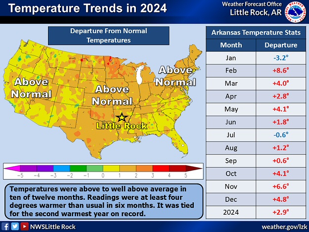
In 2024, temperatures were much warmer than usual (a Top 3 warm year). Readings were at least four degrees above average in six months. This had never happened before since data collection began (in 1895). The year featured the second warmest February and November on record, the second warmest spring, and the third warmest fall.
At individual sites (using data going back to the late 1800s), Little Rock (Pulaski County) had the second warmest year on record, with Top 3 warm years at Fayetteville (Washington County), Fort Smith (Sebastian County), and Texarkana (Miller County).
Warm and Wet Streak Continues
Temperatures and precipitation in Arkansas were above average for the tenth straight year. These are the longest such streaks in the state since records began in 1895.
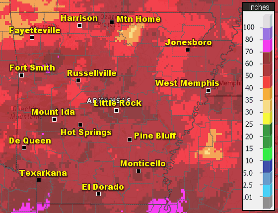
In the pictures: The wettest conditions in 2024 were found along the Arkansas River from west central into central Arkansas, and also in the far southwest. The driest areas were found in portions of the north/east and the Ouachita Mountains. Overall, it was a wetter than usual year by four to five inches. Note: Amounts in parts of the north (especially Fulton and Izard Counties) are underestimated.
The year started wet through the spring, but precipitation was largely subpar in the late summer and early fall (including a Top 10 dry October). This is when drought became an issue in the western half of Arkansas (especially in the northwest).
Precipitation in 2024
Site
Amount
Normal
+/-
% of Normal
Fayetteville (NW AR)
44.65
46.96
-2.31
95%
Harrison (NC AR)
48.92
44.50
+4.42
110%
Jonesboro (NE AR)
49.51
48.51
+1.00
102%
Fort Smith (WC AR)
55.94
47.34
+8.60
118%
Little Rock (C AR)
58.42
50.42
+8.00
116%
West Memphis (EC AR)
46.08
50.40
-4.32
91%
Texarkana (SW AR)
56.57
48.87
+7.70
116%
El Dorado (SC AR)
58.49
52.12
+6.37
112%
Pine Bluff (SE AR)
49.19
50.81
-1.62
97%
Note: The statewide average precipitation was 54.52 inches, or 4.91 inches above average. This was the 34th wettest year on record.
Average Temperatures in 2024
Site
Avg Temp
+/-
Fayetteville (NW AR)
61.7°
+4.3°
Harrison (NC AR)
60.8°
+2.5°
Jonesboro (NE AR)
63.2°
+3.1°
Fort Smith (WC AR)
65.6°
+3.2°
Little Rock (C AR)
66.1°
+4.4°
West Memphis (EC AR)
63.0°
+0.4°
Texarkana (SW AR)
69.0°
+5.0°
El Dorado (SC AR)
66.0°
+1.8°
Pine Bluff (SE AR)
66.4°
+3.4°
Note: The statewide average temperature was 63.3 degrees, or 2.9 degrees above average. This was tied for the 2nd warmest year on record.
In the picture: Leading up to the eclipse on 04/08/2024, the large scale pattern featured a south/southwest flow into Arkansas. This eventually pumped a lot of moisture into the region, and rain became widespread. Preceding the rain, a cold front brought a brief period of dryness, and made eclipse viewing possible.
Aside from the weather, there was a rare total solar eclipse on April 8th (the first since 1918 across the state). Leading up to the event, it was understood that viewing such an eclipse was iffy given a very changeable weather pattern this time of year.
"It looks like a volcano." Zoomed in look at some of the prominences during the amazing #SolarEclipse2024! Turn up the audio and listen as we were amazed to be able to see these. You could see these with the naked eye. #solar#sunpic.twitter.com/YfEzh6d86h
In the video: The view of the eclipse was spectacular at Hardy (Sharp County) on 04/08/2024. The video is courtesy of Charles Peek via X (formally Twitter).
Fortunately, a well timed cold front and drier air gave local residents and scores of visitors a small window of opportunity to catch a glimpse of the moon completely blocking the sun in the early afternoon.
The following are some of the larger/most impactful events of 2024, and were mentioned in previous writeups on this website throughout the year.
Across Arkansas: Winter Weather
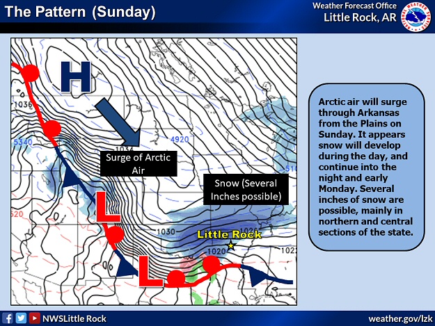
In the picture: A surge of Arctic air was incoming by 01/14/2024, and there was accumulating snow (especially in northern and central Arkansas).
The year began with a surge of Arctic air on January 14th. Frigid temperatures were noted over the next few days, and there was accumulating snow (especially in northern and central Arkansas).
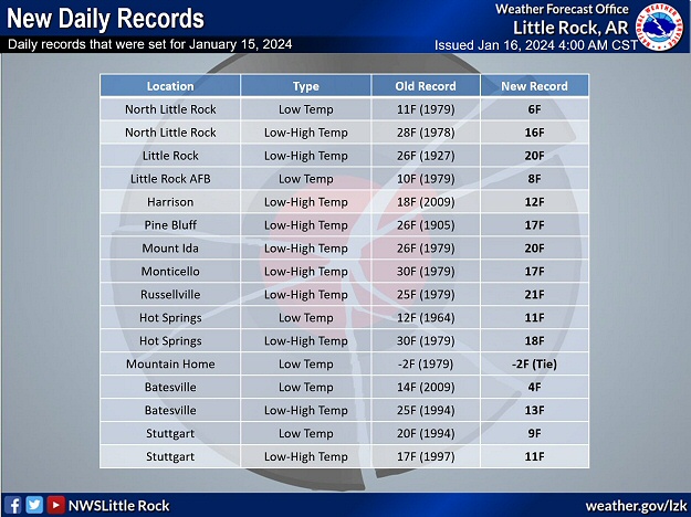
In the picture: Numerous cold record temperatures were tied or broken on 01/15/2024.
On the 15th, daily record lows were broken (and shattered in some cases) at several locations including Batesville (Independence County), Hot Springs (Garland County), the Little Rock Air Force Base in Jacksonville (Pulaski County), North Little Rock (Pulaski County), and Stuttgart (Arkansas County). There were numerous record cold highs in the teens and lower 20s.
Through the 15th, Zach (Searcy County) racked up 9.5 inches of snow, with 8 inches at Culp (Baxter County) and Saint Joe (Searcy County), 7.5 inches at Brockwell (Izard County) and just southwest of Marshall (Searcy County), 7 inches near Buffalo City (Baxter County), Calico Rock (Izard County), Deer (Newton County), Melbourne (Izard County), and Violet Hill (Izard County), 6.5 inches at Cherokee Village (Sharp County), and 6 inches at Glencoe (Fulton County), a couple of miles south of Kingston (Madison County), close to Pindall (Searcy County), and at Vendor (Newton County).
Toward central sections of the state, there were a lot of two to three inches accumulations. This included the Little Rock (Pulaski County) area. Across the south, a half inch to two plus inches of sleet and some snow was reported.
It was cold this morning, in fact very cold across Arkansas. The lowest official temperature we could find was - 7° in both Compton and Lead Hill. Are congratulations in order or not? #arwxpic.twitter.com/tGt4DixQto
In the picture: A couple of the coldest places on 01/16/2024 were Compton (Newton County) and Lead Hill (Boone County) with a low temperature of -7 degrees.
After snow/clouds went away, the 16th began with a staggering -14 degree temperature at Gilbert (Searcy County), and -10 degrees at Fayetteville (Washington County). Compton (Newton County), Lead Hill (Boone County), and Winslow (Washington County) chimed in with -7 degrees. Even with sunshine, it was subfreezing day statewide.
The frigid scenario carried on into the 17th. Arctic high pressure was overhead at this point (after building this way from Canada), and this was arguably the most bone-chilling morning for many of us. Folks in Evening Shade (Sharp County) woke up to a -10 degree reading, and West Memphis (Crittenden County) and Jacksonville (Pulaski County) had -6 degrees and -3 degrees respectively. The 1 degree temperature at Little Rock (Pulaski County) was the coldest since February 16, 2021 (-1 degree). Before that, there was nothing that low until December 23, 1989 (-1 degree).
Across Arkansas: Severe Weather/Heavy Rain/Flash Flooding
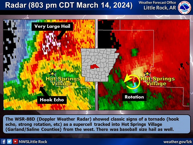
In the picture: The WSR-88D (Doppler Weather Radar) showed classic signs of a tornado (hook echo, strong rotation, etc) as a supercell tracked into Hot Springs Village (Garland/Saline Counties) from the west around 800 pm CDT on 03/14/2024. There was baseball size hail as well.
After an early season tornado from Sardis to East End (both in Saline County) on February 9th, the second tornado of the year hit Hot Springs Village (Garland/Saline Counties) a month later (on March 14th).
The chaos started close to Highway 7 just north of the Mountain Valley (Garland County) community. Numerous trees were downed or snapped along the path (8 to 9 miles) of the tornado (rated EF2). Many homes were damaged mainly by falling trees. Baseball size hail was also reported. The local water treatment plant lost power, and relied on generators. Leaks were also detected, and the system became overwhelmed leading to water shortages.
In the video: There was a lot of damage/chaos following a tornado (rated EF2) in Hot Springs Village (Garland/Saline Counties) during the evening of 03/14/2024. The video is courtesy of Brian Emfinger via YouTube.
Elsewhere, there was softball size hail west of Sulphur Springs (Benton County), and tea cup size hail at Gravelly (Yell County). Tennis ball to baseball size stones pelted Gravette and Maysville (both in Benton County), with golf balls near Prattsville (Grant County) and at Y City (Scott County).
Largest Hail in 2024
There were a half dozen cases of two inch diameter hail or bigger on March 14th, and five instances of similar size hail on May 24th/26th. Softball size hail pelted areas west of Sulphur Springs (Benton County) during the former event, and Slovak (Prairie County) during the latter episode. How rare is huge hail? With the exception of 2005 and 2013, baseball size or larger hail was observed in Arkansas at least once a year since 1980 (through 2024). Hail at least softball size occurred once every other year (24 of 45 years). As far as numbers of reports, of the roughly 6,489 instances of quarter size or larger hail, 2,672 were at least golf balls (41.2% of reports), 300 were at least baseballs (4.6% of reports), and 62 were at least softballs (1.0% of reports). The largest hailstones were five inches in diameter (slightly larger than a DVD) on January 21, 1999; April 2, 2006; and May 4, 2020.
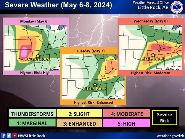
In the picture: There was a risk of severe weather in parts of Arkansas on May 6-8, 2024.
A very active weather pattern was in store from the central and southern Plains to the mid-Mississippi, Ohio, and Tennessee Valleys as well as the southeast states from May 6th through the 8th. The event garnered a lot of attention given a very rare high risk of severe weather (the first since March 31, 2023) in portions of Texas and Oklahoma on the 6th, and a moderate risk of severe storms from southern Missouri into central Tennessee on the 8th.
In Arkansas, the event got off to a bang with a line of storms arriving in the northwest counties during the wee hours of the 7th (between 230 and 330 am CDT). The line cranked out a whopping seven tornadoes in parts of Crawford, Franklin, Madison, and Washington Counties. The strongest of these (rated EF2) was on the ground almost twelve miles from southeast of Stillwell, OK to just east of Odell (Washington County). The other tornadoes were generally weak (rated EF1).
Footage of the tornado damage in Hot Springs. Garland County Emergency Management is performing damage assessments. No injuries reported at this time. There is an estimated 3,068 w/o power, but Entergy crews are working to restore service. #ADEM#ADPSpic.twitter.com/ogDLEORyRE
In the video: Damage was extensive along Lake Hamilton (Garland County) as viewed from a drone camera following a tornado (rated EF2) on 05/08/2024. The video is courtesy of the Arkansas Division of Emergency Management (ADEM) via X (formally Twitter).
Between 1215 am and 1230 am CDT on the 8th, a storm to the southwest of Hot Springs (Garland County) showed signs of rotation. A tornado emerged about ten miles southwest of town, and headed toward Lake Hamilton. The tornado (rated EF2) pushed mobile homes off their blocks, and battered multiple structures (commercial, industrial, and residential). Most of the damage was done to siding, doors, windows, and roofs. Condos had sections of roofs removed, and large trees fell on some houses. Floating docks were also not spared.
In the video: The WSR-88D (Doppler Weather Radar) showed a supercell (storm with rotating updrafts) that spawned multiple tornadoes (some deadly) in extreme northern Arkansas during the predawn hours of 05/26/2024. A second storm followed closely behind, and produced additional significant severe weather. The video is courtesy of Todd Yakoubian via X (formally Twitter).
Conditions were horrific before dawn on May 26th. The environment looked ominous (warm/humid with lots of shear to promote rotation in developing storms) from the central and southern Plains to southern Missouri and extreme northern Arkansas.
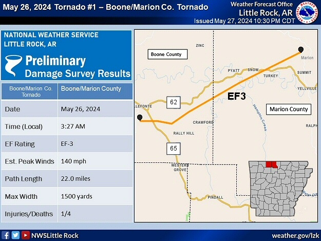
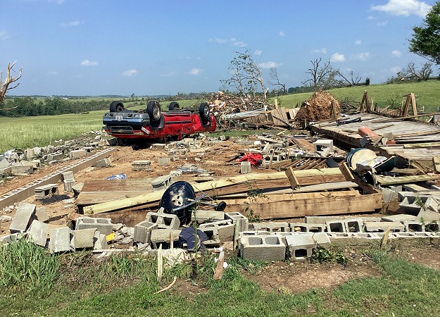
Fifteen tornadoes cut swaths from Benton County eastward through Madison, Boone, Marion, Baxter, Fulton, Sharp, and Randolph Counties. Most of these were weak (rated EF0/EF1) and did not last long. However, survey teams confirmed at least EF3 damage and longer track tornadoes through Briarcliff (Baxter County), west of Decatur (Benton County), and Olvey (Boone County). There was some EF2 damage south of Decatur, west of Centerton, and at Rogers (all in Benton County), as well as north/west of Salesville (Baxter County).
In the pictures: In the Little Rock County Warning Area, two tornadoes (both rated EF3) ripped across portions of Boone/Marion Counties (a 22 mile track) and Marion/Baxter/Fulton Counties (a 36 mile track) on 05/26/2024. These were two of fifteen tracks across northern Arkansas early in the day.
Houses/mobile homes and businesses were heavily damaged or destroyed, and at least ten fatalities were counted (5 in Benton County, 2 in Boone County, 2 in Marion County, and 1 in Baxter County).
Half of the casualties were directly related to tornadoes (in Boone, Marion, and Baxter Counties). Another death was the result of straight-line winds up to 90 mph leveling a tree onto a manufactured home at Monte Ne (Benton County). A woman at Rogers (Benton County) passed away after her CPAP machine (providing oxygen) stopped running due to the loss of electricity. A lineman overheated while trying to restore utilities near Decatur (Benton County) and suffered a heart attack. Finally, two people drowned in a swollen Sugar Creek near Bella Vista (Benton County).
Strongest Gusts in 2024
There were ten cases of damaging wind gusts at least 75 mph on May 26th, and seven instances of similar gusts on August 16th/18th. During the former event, destructive gusts up to 100 mph blasted through areas from Bentonville to Little Flock (both in Benton County) and Hardy to Williford (both in Sharp County). Gusts from 75 to as high as 90 mph roared through Benton, Clark, Crawford, Franklin, Hot Spring, Sebastian, and Yell Counties (western Arkansas) during the latter episode.
In the pictures: In the Little Rock County Warning Area, a house was destroyed near Olvey (Boone County), and the city hall building in Briarcliff (Baxter County) took a direct hit on 05/26/2024. Two separate tornadoes (both rated EF3) were responsible for the destruction.
This was the deadliest event in the state in ten years (since the Mayflower/Vilonia Tornado of April 27, 2014 that claimed 16 lives). Up to tennis ball size hail pelted Omaha (Boone County) and Rogers (Benton County). Power was knocked out to at least 125,000 utility customers.
The Origin of the Deadly Storm
The life of the parent supercell that caused most of the significant damage early on May 26th can be traced back to near Canton, OK (225 miles west of Arkansas) around 730 pm CDT on the 25th. Not far from town, a cluster of storms popped up and headed toward us. One of the storms became dominant/rapidly strengthened east of Enid, OK around 900 pm CDT. The storm arrived in northwest Arkansas four hours later.
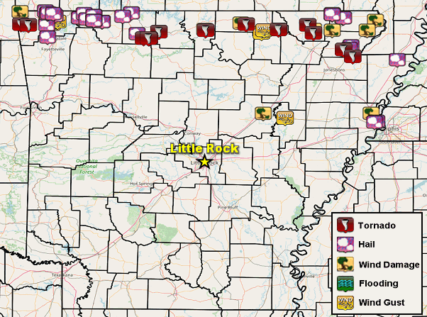
In the picture: Severe weather reports in the twenty four hour period ending at 700 am CDT on 05/27/2024.
Farther east, an 86 mph gust was recorded at an airport near Ash Flat (Sharp County). Many trees were uprooted/snapped (by estimated 90 to 100 mph gusts) and a mobile home was rolled between Ozark Acres and Williford (both in Sharp County). Fallen trees blocked roads around Pocahontas (Randolph County) and Corning (Clay County).
The episode ended with a passing cold front and one more round of severe storms during the afternoon/evening of the 26th and into the wee hours of the 27th. A house was torn up at Paragould (Greene County), and the culprit was a tornado (rated EF2). Another brief weak tornado (rated EF1) was identified about six miles north of Lester (Craighead County).
Record Outbreak of Tornadoes?
The 17 tornadoes tallied on May 26th (15 early in the day and 2 in the evening) were the most in a day since April 25, 2011 (18 tornadoes). The tornado (rated EF3) west of Decatur (Benton County) had a path width of 3200 yards, which is a state record (since 1950). There were 10 fatalities which is the most since April 27, 2014 (16 deaths).
Let's check out more significant events in 2024 across Arkansas. For the rest of the story, click here.