|
| Yearly Reports |
| Interested in what kind of weather occurred in a recent year? Check out the most memorable events below. |
|
|
 |
Arkansas Yearly Climate Summary (2022)/Pg2 |
 |
| |
| Across Arkansas: Severe Weather |
|
|
| |
|
On March 6th, scattered showers and thunderstorms flared up during the afternoon, but it was one storm in particular that caught everyone's attention. This supercell (storm with rotating updrafts) tracked from southeast Johnson County into Pope County shortly after 500 pm CST. Less than twenty minutes later, there was a confirmed tornado a few miles northwest of Dover (Pope County).
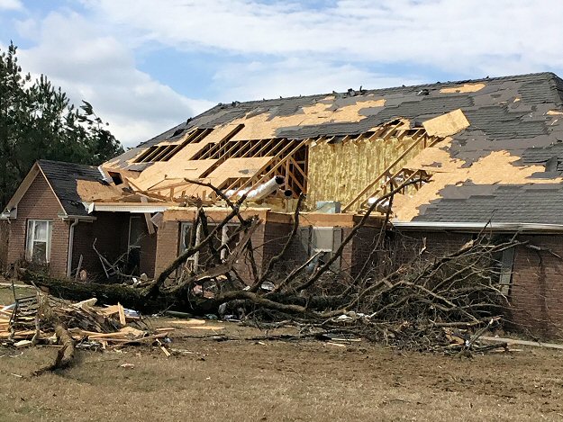
The tornado (rated EF1) crossed Highway 7 just north of Pleasant Valley (Pope County). Numerous trees were uprooted, and trees came down as a vehicle was driving through the area. Miraculously, the driver (a young man) was unharmed. Along the highway, the sliding doors at a volunteer fire department were blown out. To the west, a home took a direct hit, and much of its roof was roughed up. East of the highway, a 55 year old man was standing outside, and was injured after being thrown onto a steel gate on his porch. The tornado dissipated in the Ozark National Forest south of Solo (Pope County).
|
|
|
| |
|
The storm cranked out another brief tornado (rated EF1) between Leslie (Searcy County) and Flag (Stone County). A stronger tornado (rated EF2) spun up to the southwest of Sage (Izard County) and tore through town. Numerous trees were snapped, and barns and sheds were destroyed (including a 1500 square foot horse barn). Several homes had roof damage. To the northeast, a mobile home was thrown, and one person was injured.
As the tornado neared Evening Shade (Sharp County), a modular home was obliterated west of town (in Izard County). The occupants fled to a nearby metal shipping/storage container, and this rolled into some nearby trees. Four folks were injured (one seriously).
One more brief tornado (rated EF1) dismantled outbuildings and chicken houses southeast of Dalton (Randolph County). Soon after (by 830 pm CST), the storm weakened considerably.
During the predawn hours of the 7th, a couple of weak tornadoes (rated EF1) were cranked out by a supercell in southern Arkansas. The tornadoes were north/west of Star City (Lincoln County) and north/west of Gillett (Arkansas County) between 115 am and 215 am CST. Mainly tree debris was found when the areas were surveyed, and a chicken house had tin removed.
|
|
In the Memphis County Warning Area, there was a weak tornado (rated EF0) southwest of Cash (Craighead County) a few minutes after 400 pm CST on the 6th. A rain wrapped tornado (rated EF0) was witnessed east of McDougal (Clay County) just before 530 pm CST.
|
|
|
| In the video: Very large hail was noted near New Blaine (Logan County) on 04/11/2022. The video is courtesy of Brian Emfinger via Twitter. |
|
| |
|
In April, while there were tornadoes, the bigger story was the hail. There were over two dozen reports of golf ball size hail or larger on the 11th. Hail larger than softballs (4.5 inches in diameter) was witnessed near New Blaine (Logan County), with baseball size stones at Branch and Charleston (both in Franklin County), just west of Delaware (Logan County), a few miles north of Mayflower (Faulkner County), and around Cabot (Lonoke County). The hail dented vehicles, cracked windshields, broke windows in homes, poked holes in siding, and pelted roofs.
|
| How Rare is Huge Hail? |
|
With the exception of 2005 and 2013, baseball size or larger hail was observed in Arkansas at least once a year since 1980 (through 2022). Hail at least softball size occurred once every other year (22 of 43 years). As far as numbers of reports, of the roughly 6,063 instances of quarter size or larger hail, 2,537 were at least golf balls (41.8% of reports), 269 were at least baseballs (4.4% of reports), and 54 were at least softballs (0.9% of reports). The largest hailstones were five inches in diameter (slightly larger than a DVD) on January 21, 1999; April 2, 2006; and May 4, 2020.
|
|
Four weak tornadoes (rated EF1) were counted. Between 500 pm and 600 pm CDT, two of the tornadoes were produced near Bloomer (Sebastian County) and just south/east of Charleston (Franklin County). By 630 pm CDT, there was another tornado east/northeast of Scranton (Logan County). The last tornado cut an almost eight mile swath between Mayflower (Faulkner County) and Gibson (Pulaski County).
|
| More Hail in October |
|
On October 12th and 15th, there were forty two reports of quarter size hail or larger in the northern half of Arkansas. There were eighteen instances of ping pong ball size stones or bigger.
|
|
|
| In the picture: Severe weather reports on April 15-16, 2022. |
|
| |
|
On the 15th, it happened again (more huge hail). Between 700 pm and 1000 pm CDT, a storm tracked east/southeast through Baxter, Fulton, Sharp, Lawrence, Greene, Craighead, and Mississippi Counties. Along the way, hail was softball size or larger at Cherokee Village (Sharp County), Lake City (Craighead County), and five miles west of Viola (Fulton County). Baseball size hail was noted at Caraway (Craighead County) and southeast of Walcott (Greene County).
Farther west before 700 am CDT on the 16th, more storms dropped tennis ball size hail at Springdale (Washington County), and golf ball size hail at Oden (Montgomery County).
|
| What About the Tornado Emergencies? |
|
On April 11th and 15th (twice in less than a week), Tornado Emergencies were declared by the National Weather Service in Little Rock. Tornado Emergencies are usually reserved for rare situations when: (1) a severe threat to human life is imminent or ongoing, (2) catastrophic damage is imminent or ongoing, and (3) a tornado is confirmed visually and/or by radar.
While (3) applied in both cases, (1) and (2) were based on reports of destruction of property. It was assumed the destruction was caused by tornadoes, when it was actually wind driven large hail (baseball size or bigger). Even if it was clear that hail was the culprit, Tornado Warnings (versus Severe Thunderstorm Warnings) would have certainly been issued (given strong rotation). Also, it appears some reports of tornado sightings were erroneous, and this added to the confusion.
It must be mentioned that sometimes it is difficult to know exactly what is happening, especially in rural settings when reports are spaced apart or non-existent. Time of day is also a factor, with details hidden by darkness at night. During the Stone/Izard County Tornado of April 14, 1996, there were no reports of significant damage until the event was over. It took awhile to find out an F4 monster tracked forty miles, and killed seven people (the deadliest tornado nationwide that year). If this had occurred today, and the rules were followed, there would probably not be a Tornado Emergency (because of a lack of ground truth).
The moral of the story is forecasters in warning mode are trained to do the best they can with information they have to protect life and property. The goal is to make sure people are not caught off guard, and have time to find shelter. Keeping folks safe is the name of the game. The mission was accomplished on April 11th and 15th...tornadoes or not.
|
 |
| Risk of Severe Weather | CAPE/Shear at 700 pm CDT |
| In the pictures: According to an outlook from the Storm Prediction Center (in Norman, OK), there was an enhanced to moderate risk of severe weather from southwest into central Arkansas on 11/04/2022. This is where modest levels of CAPE (Convective Available Potential Energy/a measure of instability) and shear (wind energy to force storm development/drive storms/create rotation) came together. |
|
| |
|
And now for the biggest tornado outbreak of the year, and it did not happen in the spring. Instead, the outbreak unfolded in early November from northeast Texas into western and central Arkansas.
|
|
|
| In the picture: Several rotation tracks were associated with severe storms moving from southwest to northeast across the western half of Arkansas during the evening of 11/04/2022. |
|
| |
|
Winds turned with height, and caused multiple storms to rotate in the area of greatest concern. Numerous Tornado Warnings were issued, with storms arriving in Arkansas (in the west) shortly before 700 pm CDT.
|
| Tornadoes in Arkansas |
|
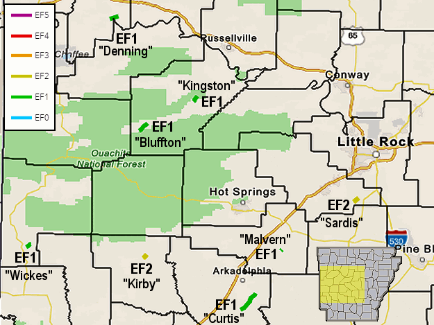
Sixteen (16) tornadoes were counted in Arkansas following the severe weather outbreak on November 4th. This is the most tornadoes for the month since November 27, 2005. On that day, two dozen tornadoes raked through northern and western sections of the state.
|
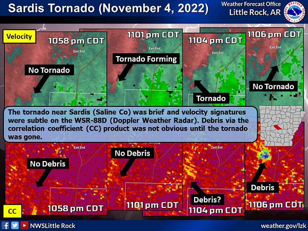 |
| In the picture: The tornado (rated EF2) near Sardis (Saline County) was brief and velocity signatures were subtle on the WSR-88D (Doppler Weather Radar) during the evening of 11/04/2022. Debris vis the correlation coefficient (CC) product was not obvious until the tornado was gone. |
|
| |
|
In the Little Rock County Warning Area, eight tornadoes were spawned. A tornado (rated EF2) was confirmed just to the south and east of Sardis (Saline County). This tornado was brief and somewhat difficult to pick out on the WSR-88D (Doppler Weather Radar). Debris from tornado damage was not prominently displayed until the tornado was gone. Warning for such a tornado (and most others during this event) was challenging. Homes were damaged (mainly roofs), outbuildings were damaged or destroyed, and numerous trees were toppled or snapped. There was another tornado (rated EF2) just south and east of Kirby (Pike County) that ripped apart a barn.
|
|
|
| |
|
Toward the Oklahoma border, damage to chicken houses and trees was found near Wickes (Polk County). This was the result of a tornado (EF1). Two more tornadoes (both rated EF1) were identified between Gravelly and Bluffton (both in Yell County), and four to five miles southeast of Danville (Yell County). There was a brief (0.4 mile path) tornado (rated EF1) south of Malvern (Hot Spring County), and a more persistent (7.7 mile path) tornado (rated EF1) south and east of Curtis (Clark County) that crossed the Ouachita River. Finally, a tornado (EF1) traversed the Arkansas River north of Roseville (Logan County).
|
|
In the Tulsa County Warning Area, the aforementioned Logan County tornado was one of three tornadoes tallied between Branch and Altus (both in Franklin County). Additional tornadoes were noted between Huntington and Mansfield (both in Sebastian County), northeast of Winslow (Washington County), and not far from Green Forest (Carroll County) and Huntsville (Madison County). All tornadoes were weak (rated EF0/EF1). One other tornado was detected on radar by a debris signature at Fort Chaffee (Sebastian County). However, the area could not be surveyed (a fire exercise was in progress), and the tornado was assigned an EFU (unknown) rating. In the Shreveport County Warning Area, homes and chicken houses were pummeled, a mobile home was rolled, and a cell tower collapsed north and west of Center Point (Howard County). A tornado (rated EF2) was to blame.
|
| Across Arkansas: Summer Heat/Drought |
 |
| In the picture: Drought conditions as of 10/11/2022. |
|
| |
|
Heading into mid-October, drought conditions were widespread across Arkansas. By the 13th, burn bans were posted in 71 of 75 counties, and there was a high to extreme wildfire danger. The drought was the result of heat and a lack of rain in June/July, and bone dry conditions in September.
The drought got going from June 11th to July 26th. During that time frame, umbrellas were not needed much. Outside of a localized cloudburst in southern Arkansas on July 3rd, and over five inches of rain at El Dorado (Union County), precipitation departures were three to more than five inches in the minus category.
|
| Precipitation (June 11th to July 26th, 2022) |
| Site |
Amount |
Normal |
+/- |
% of Normal |
| Fayetteville (NW AR) |
0.47 |
6.11 |
-5.64 |
8% |
| Harrison (NC AR) |
1.74 |
5.58 |
-3.84 |
31% |
| Jonesboro (NE AR) |
1.40 |
5.00 |
-3.60 |
28% |
| Fort Smith (WC AR) |
0.11 |
5.87 |
-5.76 |
2% |
| Little Rock (C AR) |
0.83 |
5.06 |
-4.23 |
16% |
| West Memphis (EC AR) |
1.40 |
6.20 |
-4.80 |
23% |
| Texarkana (SW AR) |
0.70 |
5.26 |
-4.56 |
13% |
| El Dorado (SC AR) |
6.38 |
5.50 |
+0.88 |
116% |
| Pine Bluff (SE AR) |
1.52 |
5.18 |
-3.66 |
29% |
|
It was very hot, especially in the west. Triple digit heat was experienced on twenty five days at Texarkana (Miller County) in June and July, and twenty four days at Fort Smith (Sebastian County).
|
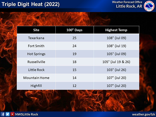 |
| In the picture: Parts of western Arkansas already experienced at least two dozen days of triple digit heat in 2022 through the end of July. |
|
| |
|
The temperature reached 107 degrees at Mountain Home (Baxter County) on July 20th, 105 degrees at Russellville (Pope County) on the 19th and 26th, and 104 degrees at Fayetteville (Washington County) on the 26th. These locations had not experienced readings this high since 2012. The thermometer showed 108 degrees at Texarkana (Miller County) on July 9th, which was the hottest temperature locally since 2011.
|
| Relief in July/August |
|
An isolated deluge on July 3rd resulted in 11.46 inches of rain at Moro Bay State Park (Bradley County). This was the highest one day total at the site dating back to 2000.
There were downpours in late July, especially in northeast and far southern Arkansas. At Alicia (Lawrence County), after 0.87 inch of rain was tallied from May 26th to July 27th (63 days), a whopping 10.45 inches of precipitation fell from July 28th to the 31st (4 days). On July 30th, 6.20 inches of rain was measured, which was the most liquid in one day at the site since records began in 1905.
Relief continued in August, as it was a wetter than normal month statewide by just over an inch (1.03 inches).
|
 |
| In the picture: A ridge of high pressure ("H") over the southern Plains was the dominant weather feature in Arkansas heading into late September, 2022. |
|
| |
|
A ridge of high pressure became dominant across Arkansas in September. Under the high, well above average temperatures were common, and raindrops were few and far between. By the end of the month, rainfall was one to more than three inches subpar.
|
| |
| Now it's time to check out significant events in 2022 outside of Arkansas. To check out the rest of the story, click here. |
|
|