|
| Yearly Reports |
| Interested in what kind of weather occurred in a recent year? Check out the most memorable events below. |
|
|
 |
Arkansas Yearly Climate Summary (2021)/Pg2 |
 |
| |
| Arkansas and Beyond: Tornadoes in December |
|
|
| |
|
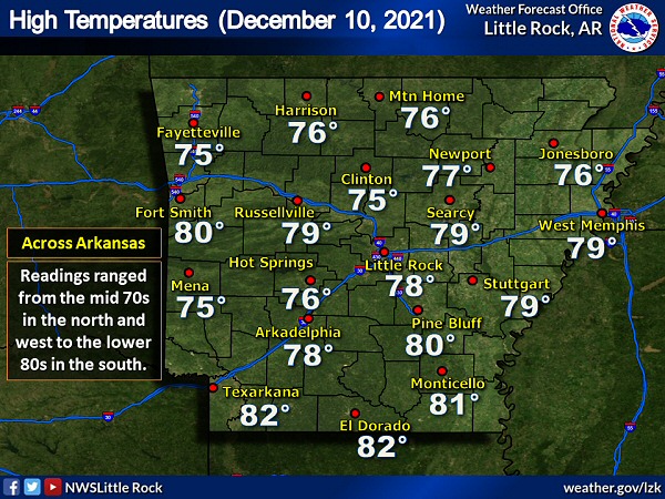
Well above normal temperatures occurred on December 10th, and it felt a lot more like spring than winter. Readings across Arkansas peaked in the mid 70s to lower 80s. A cold front surged through the state during the overnight hours, and temperatures dropped into the lower 30s to mid 40s (falling 35 to 45 degrees). Such a contrast in air masses often leads to severe weather, and that's what happened...in a big way.
Thunderstorms held off until the late afternoon, and that allowed the temperature at Pine Bluff (Jefferson County) to climb to 80 degrees. This broke the previous high mark of 78 degrees set in 1918. At Little Rock (Pulaski County), the mercury reached 78 degrees which tied the record established in 1889!
|
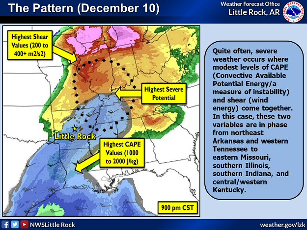 |
| In the picture: Severe weather was most likely where modest levels of CAPE (Convective Available Potential Energy/a measure of instability) and shear (wind energy to force storm development/drive storms/create rotation) came together. This happened from northeast Arkansas and western Tennessee to eastern Missouri, southern Illinois, southern Indiana, and central/western Kentucky. |
|
| |
|
Warmth and moisture ahead of the front destabilized the atmosphere, and made it easier for thunderstorms to pop up. A powerful storm system associated with the front had a lot of wind energy to help kick storms into gear, move them swiftly, and cause them to rotate. It was a recipe for disaster.
Incredibly, five dozen tornadoes were spawned mainly from northeast Arkansas into portions of Missouri, Illinois, Kentucky, and Tennessee. Eight of these were rated EF3 or higher. Across the country, this was the deadliest tornado episode on record: (1) in December (90+ fatalities), and (2) since April/May, 2011.
|
 |
| In the picture: The storm of the event tracked more than 250 miles through several states (including Arkansas, Missouri, Tennessee, and Kentucky). Two deadly tornadoes were spawned, with major structural damage noted. |
|
| |
|
The town of Mayfield, KY was hit particularly hard by a supercell (storm with rotating updrafts) that tracked from Arkansas into Missouri, Tennessee, and Kentucky and cranked out two long track tornadoes (both rated EF4). Many buildings were heavily damaged or destroyed, including a large candle factory that was completely dismantled. At least eight people were killed at the factory.
|
|
Monster storms are often accompanied by stories of disbelief and hope, and this was no different. For example, an hour after Mayfield, KY was changed forever, the town of Dawson Springs, KY was clobbered. An old black and white photo from the town was found on a windshield 130 miles away in New Albany, IN. Social media helped reunite the affected family with the photo. Just to the east in Muhlenberg County, KY, a man played a water damaged piano in what was left of his home to somehow bring peace to an otherwise chaotic situation.
A separate storm (also originating in Arkansas) was responsible for a 100 mile tornado (rated EF3) that ravaged areas from northeast of Dyersburg, TN to southeast of Hopkinsville, KY. The storm spun up a tornado (rated EF3) at Bowling Green, KY between 100 am and 130 am CST on the 11th that resulted in 15+ deaths.
Elsewhere, a warehouse was torn apart by a tornado (rated EF3) in Edwardsville, IL. Half a dozen people lost their lives.
|
| Historic Derecho to the North |
|
A few days after this event (on the 15th), a rare December derecho (long lived damaging wind producing line of storms) manufactured hurricane force wind gusts (including a 93 mph gust at Lincoln, NE) from Nebraska into Iowa, southern Minnesota, and western Wisconsin. More than 90 tornadoes (rated EF0 to EF2) occurred along the way, including first ever December tornadoes in Minnesota. Prior to the storms, high winds kicked up dust and fanned wildfires from Colorado into Kansas.
|
|
|
| |
|
Back at home, twelve tornadoes were counted in Craighead, Jackson, Mississippi, Poinsett, and Woodruff Counties (northeast Arkansas). The strongest of these (rated EF4) was on the ground from north of Bay (Craighead County) to a few miles north of Poplar Corner (Mississippi County) before going into Missouri and Tennessee. A nursing home at Monette (Craighead County) took a direct hit, and one resident died. At least twenty people were trapped, and there were several injuries. A discount store was flattened at Leachville (Mississippi County), and this resulted in a fatality. Two other tornadoes (both rated EF2) went from just north of Augusta (Woodruff County) to south of Tupelo (Jackson County), and right through Trumann (Poinsett County).
|
| Outside Arkansas: Hurricane Ida in Late August/Early September |
|
|
| In the video: The satellite showed Hurricane Ida bearing down on the Louisiana Gulf Coast by the late morning of 08/29/2021. |
|
| |
|
On the sixteenth anniversary of Hurricane Katrina, another big storm slammed into Louisiana (on August 29th). This time, it was Hurricane Ida (a Category 4 storm/150 mph sustained winds), and New Orleans, LA was in the crosshairs.
Ida made landfall at Port Fourchon, LA, and caused extensive damage (including mangled cell towers which greatly affected communication). The system unleashed one to two feet of rain that put communities under water (most notably LaPlace, LA), cut off power to more than a million people, and left many folks without a home and a clean water supply. A quarter of the buildings at Grand Isle, LA were either reduced to rubble or deemed beyond repair. More than two dozen fatalities were reported. From there, the system weakened and tracked toward the Tennessee and Ohio Valleys.
|
| Prior Flooding in Louisiana and Texas |
|
In May, the sky opened over eastern Texas and southern Louisiana. On the 10th through the 12th, there was 7.49 inches of rain at the Louis Armstrong International Airport in New Orleans, LA, with 12.80 inches for the month (a little more than seven inches above average). A week later (on the 17th), 12.49 inches of precipitation came down at Lake Charles, LA. This was the third highest one day rainfall on record in the city. Flash flood emergencies were declared locally, and also in Baton Rouge, LA. Numerous homes were flooded, and roads were closed (including parts of Interstate 10). Five deaths were confirmed in Louisiana, mainly due to people drowning in vehicles. On the 20th, at least 300 homes were evacuated near Bayou Sorrel, LA as barriers designed to stop flood waters were apparently breached. About 60 miles north of Beaumont, TX, the town of Jasper, TX turned into a lake on the 17th, and schools were forced to close. Houses and vehicles sat in water in Fannett, TX.
|
|
|
| In the picture: Forty eight hour rainfall through 800 am CST on 09/02/2021. The graphic is courtesy of the Weather Prediction Center (WPC). |
|
| |
|
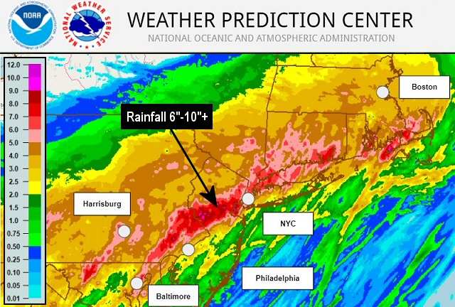
Once the remnants of Ida approached New England, the situation deteriorated in a hurry on September 1st. The system interacted with a stalled front, and six and ten inches of rain fell from central and eastern Pennsylvania to Connecticut. The daily rainfall total at New York City's Central Park was 7.13 inches (3.15 inches of this dumped in an hour), the fifth highest one day total on record. Newark, NJ logged 8.41 inches of rain, which was the most rain in one day ever. So much rain caused catastrophic flooding, with cars swept away, subway lines submerged, and buildings swamped. The National Weather Service in New York, NY issued its first ever Flash Flood Emergency. At least fifty people lost their lives (most deaths were in vehicles and basement apartments). Isolated tornadoes were spawned, including one rated EF3 at Mullica Hill, NJ. The tornado ripped up at least two dozen homes.
|
| Outside Arkansas: Heat, Drought, and Fire Across the West in the Summer |
 |
| In the picture: While parts of Arkansas were abnormally dry, drought was widespread from the western United States into the northern Plains and upper Midwest in mid-August, 2021. |
|
| |
|
Long term drought and a persistent ridge of high pressure contributed to extreme heat, low water levels, and wildfires across the western United States during the summer.
On June 15th, the temperature at Billings, MT soared to 108 degrees, which tied the all-time high in the city. The same thing happened at Sheridan, WY and Salt Lake City, UT, with the mercury topping out at 107 degrees. Wildfires were ongoing in the west as of the 18th. This included a large 165,000 acre Telegraph Fire east of Phoenix, AZ, and close to a 30,000 acre Pinnacle Fire northeast of Tucson, AZ. Lake Mead was experiencing the lowest water levels since the 1930s (about a third of its full capacity). Sitting just east of Las Vegas, NV along the Colorado River, the lake supplies water to 25,000,000 people.
All-time highs were established at Portland, OR and Seattle, WA on the 28th, with thermometers showing 116 degrees and 108 degrees respectively. Highways buckled and streetcar cables melted. The majority of homes in this part of the world are not equipped with air conditioners, so many folks went to cooling centers for relief. At least 225 people died in Washington and Oregon.
Our neighbors to the north were not exempt from blowtorch conditions. On the 29th, the temperature soared to an almost surreal 121 degrees at Lytton, British Columbia. It was an all-time high mark for Canada. The next day, evacuations were underway to flee a wildfire that burned most of the village.
|
|
|
| |
|
In late July, the Great Salt Lake in Utah was at its lowest level on record. Much of the state (99%) was experiencing extreme drought conditions (D3), with a little more than half the state in exceptional drought (D4).
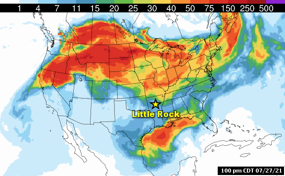
The Bootleg Fire (one of the largest wildfires in the country) near Beatty, OR had torched more than 413,000 acres as of July 27th. It was the third largest wildfire in Oregon recorded history since 1900. More than 400 structures were destroyed by flames. On the 18th, pyrocumulus clouds (as high as 30,000 feet) on the eastern perimeter of the fire spawned a tornado, which was confirmed by the National Weather Service in Medford, OR.
While drought and fire were going on in the west, it was a record monsoon season at Tucson, AZ. An impressive 8.06 inches of rain was measured in July, which was 5.85 inches above average for the month. Due to the rain, extreme drought (D3) coverage in Arizona dropped from 84% to 52% in a week (from the 20th to the 27th). Exceptional drought (D4) coverage went from 36% to 9%.
In August, drought covered a lot of real estate across the western states, with numerous large wildfires mainly in northern California, Idaho, Montana, Oregon, and Washington. The largest of these, the Dixie Fire in California, consumed more than 800,000 acres and 1,300 structures by the end of the month. It was the state's largest single (non-complex) wildfire, and the second largest wildfire on record (behind the million acre August Complex wildfire in 2020).
|
|
|
| In the video: The Marshall Fire near Boulder, CO was captured by the WSR-88D (Doppler Weather Radar) on 12/30/2021. The video is courtesy of the National Weather Service in Boulder, CO. |
|
| |
|
As the year ended, there was sorrow in Colorado on December 30th. Winds topped 100 mph (caused by a mountain wave/air rapidly descending from the mountains into the foothills) around Boulder, CO, and downed power lines apparently started a fire. The circumstances became dire in a hurry, with the fire rapidly overtaking 1,600 acres, and forcing 30,000 residents to move out. Up to 1,000 homes burned to the ground, including at least one hotel. Communities most affected were Broomfield, CO, Louisville, CO, and Superior, CO. Amazingly, there were only a handful of injuries, but two people were missing (later pronounced dead). Officials mentioned this may be the costliest fire on record in the state.
|
| Outside Arkansas: Honorable Mentions |
|
|
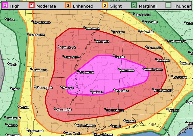
| In the picture: The forecast indicated a moderate to high risk of severe weather from eastern Arkansas and northeast Louisiana to southwest Tennessee, much of Mississippi, and Alabama on 03/17/2021. The forecast was courtesy of the Storm Prediction Center. |
|
| |
|
In mid to late March, there were two rare high risk severe weather events back-to-back in the southeast United States. On the 17th, at least two dozen tornadoes (given ratings of EF0 to EF2) were confirmed from southern Mississippi into central Alabama. It was a bigger deal on the 25th/early on the 26th from Alabama into Georgia. While there were fewer tornadoes (a dozen or so), they were more destructive and deadly. There were four tracks more than thirty miles (rated EF2 to EF4). At least seven deaths were reported, mainly in Ohatchee, AL and Newnan, GA.
|
|
|
| In the picture: An almost surreal hailstone measuring 6.4 inches in diameter (a Texas state record) was collected at Hondo, TX on 04/28/2021. The information is courtesy of the National Weather Service in Austin/San Antonio, TX. |
|
| |
|
It was a night to remember at Norman, OK, on the north side of Fort Worth, TX, and west of San Antonio, TX on April 28th. There was an incredible amount of hail, and baseball to larger than grapefruit size stones were common. Numerous vehicles were dented, windows were busted out in cars, homes, and businesses, roof shingles were beat up, and holes were punched in siding on buildings. Incredibly, the largest stones managed to crash through the ceilings of some houses and land in the living space. At Hondo, TX, a 6.4 inch diameter stone was collected, which was the largest on record in Texas.
On August 21st, an apparent Tennessee state record 17.06 inches of rain dumped at McEwen, TN (in a twenty four hour period ending during the morning). To the west of town in nearby Waverly, TN, a wall of water moved along Trace Creek and made it appear that a large tornado pummeled the community. Video showed the event unfolding quickly, and there was not enough time to prepare. Tragically, twenty people lost their lives.
|
| Not the Only Flood in Tennessee |
|
A little more than seven inches of rain fell at Nashville, TN in two days (March 27th/28th), with water into homes and businesses and vehicles submerged. At least 130 people had to be rescued, and at least four people were killed. Interstate 24 was shut down southeast of the city during the morning of the 28th due to flooding. Several area rivers experienced Top 5 crests. It was somewhat reminiscent of the calamitous flood event in early May, 2010.
|
|
|