|
| Yearly Reports |
| Interested in what kind of weather occurred in a recent year? Check out the most memorable events below. |
|
|
 |
Arkansas Yearly Climate Summary (2020)/Pg3 |
 |
| |
| Significant Events Across the Country |
|
|
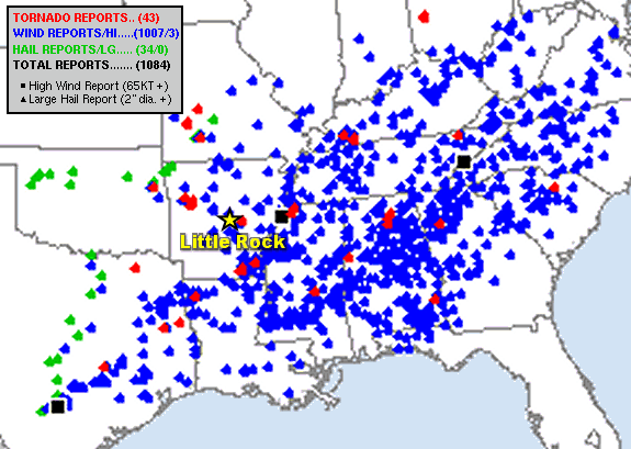
| In the picture: There was widespread wind damage, some large hail, and isolated tornadoes from the southern Plains to the mid-Atlantic states in the forty eight hour period ending at 600 am CST on 01/12/2020. The graphic is courtesy of the Storm Prediction Center. |
|
| |
|
In January, there was a huge severe weather outbreak from the southern Plains to the southeast United States on January 10th/11th. From east Texas to the Carolinas and Virginia, there were over 1,000 reports of wind damage! A tornado (rated EF1) downed a tree onto a mobile home southwest of Nacogdoches, TX. One person was killed. A long track tornado (rated EF2/41 miles) went from near Bossier City, LA to Arcadia, LA, and mowed down a considerable number of trees and structures. Two more fatalities occurred in a mobile home. At Oil City, LA, a tree fell on a home and killed one of the occupants. To the east, three people lost their lives due to a tornado (rated EF2) in Carrollton, AL.
|
| Most Active Days of 2020 |
|
According to the Storm Prediction Center in Norman, OK, the top three severe weather days (with the most reports of tornadoes, damaging wind, and hail) of the year were April 12th, August 10th, and January 11th.
|
|
|
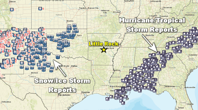
| In the picture: A visible satellite image showed a band of heavy snow in portions of Texas and Oklahoma during the morning of 02/06/2020. |
|
| |
|
Late on February 4th/early on the 5th, snow piled up in a hurry in northern sections of Texas, with 14 inches of powder at Jayton, TX, and up to a foot of accumulation at Snyder, TX. Almost 8 inches of snow was measured at Midland, TX, which was the largest total since 10.6 inches in January, 2012. Farther northeast, roughly 5 inches of snow blanketed Oklahoma City, OK.
|
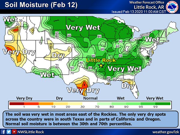 |
| In the picture: The soil was very wet (well above normal moisture) in many areas east of the Rockies on 02/12/2020. |
|
| |
|
There was lots of rain from eastern Texas through northern Louisiana, northern Mississippi, southern Tennessee, and northern Alabama on February 10th through the 12th. Flooding was extensive, with many roads under water.
Near Starkville, MS, the Oktibbeha County Lake Dam was in danger of failing. A shelter was opened in case mandatory evacuations were ordered. A similar situation unfolded in January after a deluge. On the 14th, the Mayor of Jackson, MS made evacuations mandatory on the northeast side of the city as the Pearl River rose. The Governor of Mississippi declared a state of emergency the next day. The river topped out just under 37 feet on the 17th, or the third highest crest in nearly 150 years of record keeping. Not far from Savannah, TN, a hillside adjacent to a swollen Tennessee River collapsed on the 15th. Two homes plunged into the current below and were destroyed. At Lacey's Spring, AL, way too much water caused U.S. Highway 231 to deteriorate. The highway was shut down indefinitely on the 13th.
In the bigger picture, much of the country east of the Rockies had a nearly saturated ground. This did not bode well for the upcoming growing season, with many fields far too muddy for planting.
|
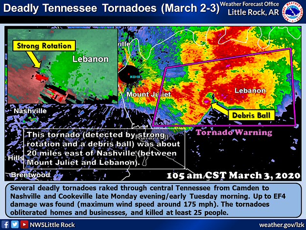 |
| In the picture: Deadly tornadoes were spawned in central Tennessee late on 03/02/2020 and early the next morning. |
|
| |
|
In early March, three deadly tornadoes were spawned in middle Tennessee between 1105 pm CST on the 2nd to 157 am CST on the 3rd. It appears the tornadoes were generated by one parent supercell (storm with rotating updrafts).
One of these tornadoes (rated EF3) lasted for just over 60 miles, and ripped through downtown Nashville, TN. Homes and businesses were heavily damaged by this tornado, and six people were killed. About an hour to the east, another tornado (rated EF4) cut a swath through areas just west of Cookeville, TN. At least thirty homes were completely destroyed, resulting in eighteen fatalities and more than eighty injuries. This was the deadliest tornado since the Lee County, AL tornado on the same day in 2019 (23 deaths).
Violent and sometimes deadly tornadoes (rated EF3 or higher) roared across Louisiana and Mississippi during the afternoon of April 12th, and in Georgia, South Carolina, and Tennessee after dark and early on the 13th.
|
|
|
| In the pictures: A tornado (rated at least EF3) caused major damage and killed three people as it tracked just east of Chattanooga, TN late on 04/12/2020. The photos are courtesy of the Hamilton County, TN Office of Emergency Management and Homeland Security via Twitter. |
|
| |
|
Just before noon CDT on the 12th, at least 200 to 300 homes were damaged by a tornado in Monroe, LA. In the hours to follow. there was a 100 mile swath of destruction and at least twelve fatalities from Walthall County, MS to Clarke County, MS (south and east of Jackson, MS), including the towns of Bassfield, MS and Soso, MS. Well after dark, a tornado clobbered the east side of Chattanooga, TN and roughed up 100 to 200 structures. Three people lost their lives. Seven people were killed when a tornado hit two mobile home parks in Murray County, GA (80 to 90 miles north of Atlanta, GA). Another fatality was reported at Cartersville, GA due to a tree on a home. Near Thomaston, GA, a house was carried from its foundation (fully intact) into the middle of State Highway 74. Nobody was there at the time. Seven more deaths were attributed to tornadoes in Hampton and Orangeburg Counties, SC (70 miles west and northwest of Charleston, SC respectively). A security guard did not make it through a tornado that dismantled an auto manufacturing plant at Seneca, SC.
A week later (evening of the 19th), a monster tornado (rated EF4) was in southern Mississippi. There was destruction from Walthall County, MS to Perry County, MS. The tornado lasted 54 miles, and was responsible for one fatality.
|
|
|
| In the picture: Watches and warnings for tornadoes and flash flooding were posted to the south and west of Arkansas at 530 pm CDT on 04/22/2020. |
|
| |
|
On the 22nd, deadly tornadoes were ongoing in southern Oklahoma and eastern Texas between 400 pm and 600 pm CDT. At Onalaska, TX, three people were killed and 150 to 200 homes were demolished by a tornado (rated EF3/140 mph winds).
In Madill, OK, a camera caught a tornado (rated EF2) spinning up quickly near several industrial buildings on the south side of town. There were two fatalities. At the time, this storm was covered by one of four Tornado Warnings posted from Roff, OK to the Red River (Oklahoma/Texas state line), a distance of only 50 miles.
|
|
|
| In the picture: A mesoscale discussion from the Storm Prediction Center (SPC) expressed concern about a cluster of strong to severe thunderstorms in southern Missouri moving into northern Arkansas during the late morning/afternoon hours of 05/03/2020. The discussion addressed a possible Severe Thunderstorm Watch across the northern counties, which was eventually issued (from 1145 am to 600 pm CDT). |
|
| |
|
On May 3rd, storms cranking out strong to damaging winds in northeast Arkansas darted into Tennessee. The storms arrived in Nashville, TN between 400 pm and 500 pm CDT. Hundreds of trees were toppled by powerful straight-line winds, including a 200-year-old oak tree at a local middle school. There was a 72 mph gust at the Nashville International Airport. At least 130,000 power outages were reported, affecting one in three Nashville Electric Service customers. The president and CEO of the company mentioned this was the largest number of outages in his almost thirty year career.
|
|
|
| In the pictures: Derechos such as the in one in Colorado, Utah, and Wyoming on 06/06/2020 are very rare in the Rockies as noted by the Storm Prediction Center via Twitter. |
|
| |
|
A similar but more rare line of storms rocketed through the Rockies on June 6th. A derecho (long-lived straight-line wind event) pummeled eastern Utah, Colorado, and Wyoming with up to 110 mph gusts. A 78 mph gust was measured at the Denver International Airport. This part of the country almost never experiences derechos, and it was the first in Colorado in almost three decades. There were at least 44 reports of gusts of at least 75 mph. This was a record number of significant gusts in one day across the country according to the Storm Prediction Center in Norman, OK.
In July, there was another derecho on the 17th/18th from the Dakotas and Minnesota into northern Michigan. A 101 mph wind gust was recorded at Churchs Ferry, ND.
|
|
|
| In the pictures: A massive plume of Saharan dust made it all the way to the Caribbean by 06/22/2020. This led to poor air quality and a darkening sky. The information is courtesy of the World Meteorological Organization via Twitter. |
|
| |
|
Here is something that seldom makes the news. A large plume of dust from the Sahara Desert was on the move toward the United States on June 22nd. The dust had made it across the Atlantic Ocean to the Caribbean Sea. The air quality was hazardous, with people advised to stay indoors. Nicknamed the "Godzilla dust cloud" by experts, such an event had not happened in at least fifty years.
In the tropics, Hurricane Isaias (Category 1 storm/85 mph sustained winds) made landfall at Ocean Isle Beach, NC on August 3rd and paralleled the East Coast as a Tropical Storm all the way to New England. Along its track, the system dumped three to more than six inches of rain, pushed over numerous trees, and caused at least three million power outages. While most tornadoes with such systems are weak, a rare EF3 tornado/145 mph winds was spawned just south and west of Windsor, NC. Two people were killed in a trailer park.
|
|
|
| In the video: Power outages were numerous from Iowa to Indiana due to a fast moving and destructive derecho (long-lived line of storms) on 08/10/2020. The information is courtesy of PowerOutage.us via Twitter. |
|
| |
|
In Iowa, a powerful and long-lived line of storms (called a derecho) produced wind gusts over 100 mph on the 10th. At Midway, IA, a gust to 112 mph was noted. There was extensive structural and tree damage about ten miles away in Cedar Rapids, IA. Incredibly, at least half of the city's trees were lost. The Warning Coordination Meteorologist (and twenty three year veteran) at the National Weather Service in the Quad Cities said this during an interview with a local television station: "I can't recall a similar incident. Usually the peak intensity is over relatively quickly. With this they just persisted and persisted." The state suffered large agricultural losses, with millions of acres of corn flattened. The storms also tore through Chicago, IL with 70 to 90 mph winds. Over a million power outages occurred in the two state area.
On the 16th, it was 130 degrees at Death Valley, CA. Pending a check for accuracy, this was the hottest temperature worldwide since July, 1931 (131 degrees at Kebili, Tunisia), and the third hottest reading ever recorded on the planet. As of the 17th, there were four straight days with highs of at least 90 degrees at Flagstaff, AZ, and five such days during the month. This had never happened before. The last time it was 90 degrees locally during the month was in 2009.
|
|
|
| In the video: There was plenty of destruction in Lake Charles, LA on 08/27/2020 following the arrival of Hurricane Laura. The video is courtesy of Brian Emfinger via Twitter. |
|
| |
|
Less than two weeks later (on the 27th), Hurricane Laura was nearing the southwest Louisiana Coast. Maximum sustained winds were up to 150 mph! This part of the state had never experienced such a powerful (Category 4) hurricane. Measured gusts exceeded 130 mph in Lake Charles, LA. Not only was there widespread structural damage, a television tower was destroyed and the WSR-88D (Doppler Weather Radar) at the local National Weather Service (NWS) office was obliterated. Staff at the office was evacuated prior to the arrival of Laura, with backup provided by NWS Brownsville, TX.
There was a lot of water in eastern Oklahoma to begin September. Six to eight inches of rain trapped people in homes, forced evacuations, and submerged cars from Panama, OK to Poteau, OK. A Flash Flood Emergency was issued for Shady Point, OK by the National Weather Service in Tulsa, OK.
On the 7th, it was at least 90 degrees for the 73rd time at Denver, CO in 2020. This tied 2012 for the most 90 degree days locally. On the 5th, it was 101 degrees, which was the all-time high temperature for September, and the latest 100 degree day on record. By the morning of the 8th, it was 31 degrees in the mountain metropolis, which became earliest recorded freeze (tied with 1962). There was also an inch of snow, which was the second earliest measurable snowfall. This also broke a streak of nineteen consecutive snowless Septembers in the city.
|
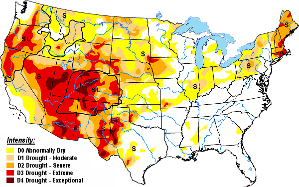 |
| In the picture: A moderate to exceptional drought (D1 to D4) was ongoing in the western United States on 10/06/2020. |
|
| |
|
Snow in the central Rockies slowed the growth of a huge fire (Cameron Peak) just north of Estes Park, CO. The fire consumed just over 100,000 acres before flakes starting flying, and was only 4 percent contained as of the 13th. The fire grew to 209,000 acres in October (the largest in state history), and was partly due to very dry conditions and widespread drought across the western United States. Wildfires were especially bad/destructive along the Pacific Coast from Washington to California.
It was absolutely awful in Oregon. Fires forced the evacuations of at least 40,000 people. Entire towns (such as Phoenix, OR and Talent, OR) and hundreds of homes were torched by fire. In a press conference, the Governor of Oregon declared: "This could be the greatest loss of human lives and property due to wildfire in our state's history." In California, an unprecedented 3,000,000 acres had burned by the 12th (and topped 4,000,000 acres by October). In northern sections of the state, the August Complex fire (a result of three dozen separate fires triggered by lightning in mid-August) was the largest ever in the state at over 850,000 acres (eventually growing to just over 1,000,000 acres and coined a "gigafire" by some people). So many fires led to copious amounts of smoke and poor air quality in parts of the west.
|
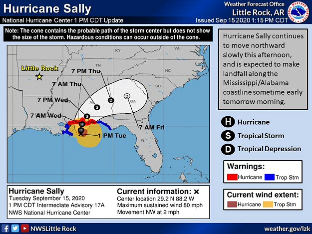 |
| In the picture: Hurricane Sally drifted (at 2 mph) toward the central Gulf Coast on 09/15/2020. The system was expected to make landfall the next morning. The forecast is courtesy of the National Hurricane Center. |
|
| |
|
In mid-September, Hurricane Sally made landfall with 105 mph sustained winds (a Category 2 storm) near Gulf Shores, AL early on the 16th. A slow north to northeast drift at 2 to 3 mph caused rain to last for hours, and there was a lot of it.
More than two feet of rain was unleashed in places from Orange Beach, AL to Pensacola, FL. At the latter location, the combination of excessive precipitation and the third highest storm surge (5.6 feet) on record locally turned the city into a giant lake. Very rare Flash Flood Emergencies were issued by the National Weather Service in Mobile, AL. There was moderate to major flooding along several area rivers. Residents along the Fish, Perdido, and Styx Rivers in Baldwin County, AL were asked to evacuate as these tributaries overflowed.
Other than the flooding, many boats were destroyed and power was knocked out to more than half a million homes. A large crane was dislodged from a barge and fell through a section of a bridge over Pensacola Bay. Just east of Gulf Shores, AL, a newly renovated fishing pier was damaged at Gulf State Park. This happened on the same day a ribbon cutting was scheduled to celebrate the renovation.
|
|
|
| In the picture: Louisiana was ground zero for tropical activity in 2020. The state spent the most time in National Hurricane Center five-day forecast cones. Not far behind was southeast Arkansas and southwest Mississippi. The graphic is courtesy of Sam Lillo via Twitter. |
|
| |
|
In early October, here came Hurricane Delta. After becoming a Category 4 storm (145 mph sustained winds), Delta reached southwest Louisiana as a Category 2 storm during the early evening of the 9th. This was the twenty fifth named storm, and a record tenth system to make landfall in the United States. This previous high mark was nine storms in 1916.
The arrival of Delta was really bad news for Lake Charles, LA and surrounding areas. This part of the state was battered by Hurricane Laura in August, with many roofs still tarped and the local WSR-88D (Doppler Weather Radar) not repaired. Because of this, a mobile radar was deployed to the site by the University of Oklahoma. The last thing needed here was another round of high winds and torrential rain, along with half a million power outages.
Meanwhile, there was a new fire to worry about in northern Colorado. The East Troublesome Fire had become the second largest wildfire ever in the state (193,000 acres). Emergency personnel battling the flames were awaiting snow to the north to slow the progression of the fire.
Triple digit heat (at least 100 degrees) is no stranger to Phoenix, AZ. However, 142 days in a calendar year with that kind of heat seldom occurs. But that became reality on the 11th, and was only one day away from tying the high mark locally.
|
|
|
| In the picture: There were many reports of an ice storm and accumulating snow to the west of Arkansas, and hurricane/tropical storm conditions south and east of the state in the sixty hour period ending at 700 pm CDT on 10/29/2020. |
|
| |
|
In late October, a major snow and ice storm unfolded from New Mexico to the Texas panhandle and on into Oklahoma. There was record October snowfall in Albuquerque, NM from the 26th through the 28th, with 4.4 inches of snow officially. On the 27th, the high was 34 degrees, which was a record cold high for the month. The low that morning (and the previous morning) was 19 degrees. It had not been that cold in October since 1917.At Taos, NM, one to two feet of snow blanketed ski slopes. From Oklahoma City, OK westward, ice accruals reached a half inch to over an inch. The weight of the ice caused tree and power line damage, and was responsible for at least 300,000 power outages.
As snow and ice were making headlines, so was Hurricane Zeta. It was the fifth tropical system to move inland in Louisiana in 2020, and it did so during the afternoon of the 28th about 65 miles south-southwest of New Orleans, LA. It was a strong Category 2 storm with 110 mph sustained winds. Zeta quickly slammed into the city, and was the strongest storm on record to hit the metro area directly.
From there, Zeta hauled to the northeast at 25 mph, and stayed a hurricane all the way into Alabama through the evening. The system was still a tropical storm early on the 29th from Georgia into the Carolinas, and its forward speed ramped up to almost 50 mph. Along the track of Zeta, damage was extensive. Numerous trees and utility poles were leveled, with many trees on homes and blocking roads. Most structural damage was roof related. A whopping two million power outages were counted.
|
|
|
| In the picture: Only five days remained in the 2020 hurricane season as of 11/25/2020. There were a record-breaking thirty named storms in the Atlantic basin. |
|
| |
|
Onward to November, and two more huge hurricanes (Eta and Iota) were nightmares in Nicaragua on the 3rd and 16th. Both were Category 4 storms (maximum sustained winds from 150 to 155 mph), and came ashore only fifteen miles apart. After weakening, Eta turned to the northeast and became a problem in the Carolinas (too much rain).
As of the 25th, there were only a few days left in the 2020 hurricane season (ending on the 30th). While it was quiet in the Atlantic basin (after the demise of Iota in El Salvador on the 18th), a staggering thirty named storms were counted since mid-May. It was the busiest season on record, topping the twenty eight named storms documented in 2005.
|
| Way Too Much Rain East of Arkansas |
|
A cold front approached the Atlantic Coast on November 11th, and ran into abundant moisture. The moisture was provided by Tropical Storm Eta that was just off the Florida Gulf Coast and tracking toward the Carolinas. On the 11th/12th, parts of the Carolinas into Virginia received six to more than ten inches of rain, and this caused a lot of flooding (to homes and businesses, roads, etc). Following twenty foot rises, an overflowing South Yadkin River inundated a campground about ten miles northwest of Statesville, NC. At least three people were killed and more than thirty people were rescued. Two people were missing. In Charlotte, NC, more than 140 people were forced to evacuate a school that was surrounded by water.
|
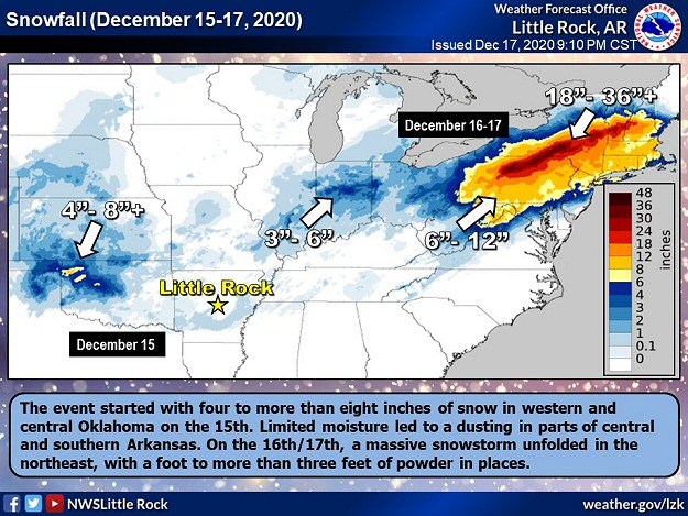 |
| In the picture: The storm system that brought four to eight inches of snow to Oklahoma on 12/15/2020 and three to six inches of snow to Indiana the next day unleashed one to more than three feet of powder in parts of the northeast. |
|
| |
|
As the year came to a close, a robust storm system cranked out around ten inches of snow in Woodward, OK on December 15th, and just over three inches in Oklahoma City, OK. Farther east, the system found more moisture, and turned into a snow machine. There was up to four feet of powder around Binghamton, NY, with two to three feet at Albany, NY, Caribou, ME, Concord, NH, Williamsport, PA, and Worcester, MA. In the New York City, NY area, eight to twelve inches of snow was measured. The official total at Philadelphia, PA was just shy of seven inches, which ended a 652 day streak with less than an inch of snow (starting on March 2, 2019).
While snow buried parts of the northeast, there was some severe weather on the warm side of the system (toward the Gulf Coast). A tornado (rated EF2) spun up on the north side of St. Petersburg, FL just before 300 pm CST on the 16th. The tornado was on the ground around thirteen miles toward Tampa, FL, and damaged or destroyed several buildings including a boat storage facility. Fortunately, there were no injuries occurred.
|
|
|
| In the picture: A little over four inches of snow accumulated in Morristown, TN on 12/24/2020. The photo is courtesy of the local National Weather Service office via Twitter. |
|
| |
|
On Christmas Eve (the 24th), snow was prevalent from eastern Tennessee to eastern Ohio and western Pennsylvania, and along Lake Erie into western New York. Morristown, TN picked up just over four inches of snow. Charleston, WV had five to six inches, with close to seven inches at Pittsburgh, PA, and around ten inches at Cleveland, OH.
In parts of west Texas, including Big Spring, TX, there was upwards of a foot of snow on the 31st. It was enough to shut down Interstates 10 and 20 temporarily. Hundreds of vehicles were stranded.
|
|
|