|
| Storm Reports |
| Are you interested in what happened during a recent event? Check out the report below. |
|
|
 |
Arkansas Yearly Climate Summary (2017)/Pg1 |
 |
| |
|
| 2017 Statistics |
| Month |
Tornadoes |
Tornado Deaths |
Wind (Tstm and Non-Tstm) Deaths |
Flood/Flash Flood Deaths |
Lightning Deaths |
| Jan |
3 (EF0:2, EF1: 1) |
0 |
0 |
0 |
0 |
| Feb |
2 (EF1: 1, EF2: 1) |
0 |
0 |
0 |
0 |
| Mar |
15 (EF0: 4, EF1: 8, EF2: 3) |
0 |
0 |
0 |
0 |
| Apr |
12 (EF0: 3, EF1: 9) |
0 |
1 |
8 |
0 |
| May |
2 (EF0: 1, EF1: 1) |
0 |
0 |
0 |
0 |
| Jun |
0 |
0 |
2 |
0 |
0 |
| Jul |
1 (EF1: 1) |
0 |
0 |
0 |
0 |
| Aug |
1 (EF0: 1) |
0 |
0 |
0 |
0 |
| Sep |
0 |
0 |
0 |
0 |
0 |
| Oct |
0 |
0 |
0 |
0 |
0 |
| Nov |
0 |
0 |
0 |
0 |
0 |
| Dec |
0 |
0 |
0 |
0 |
0 |
| Total |
36 |
0 |
3 |
8 |
0 |
| Note: The latest tornado (rated EF0) was brief and affected areas just northeast of Preston Place (Phillips County) during the morning of August 31st. The strongest tornado (rated EF2) tracked almost 37 miles from Mossville (Newton County) to Saint Joe (Searcy County) on March 6th. |
|
|
| |
|
Precipitation totals ranged from around 35 inches in far southwest Arkansas and parts of the Ouachita Mountains (of the west) to around 60 inches in a small portion of the east. Temperatures for the year were on the warm side by one to three degrees.
|
| Precipitation in 2017 |
| Site |
Amount |
Normal |
+/- |
% of Normal |
| Fayetteville (NW AR) |
51.22 |
48.51 |
+2.71 |
106% |
| Harrison (NC AR) |
40.89 |
44.14 |
-3.25 |
93% |
| Jonesboro (NE AR) |
46.07 |
48.10 |
-2.03 |
96% |
| Fort Smith (WC AR) |
47.96 |
45.46 |
+2.50 |
105% |
| Little Rock (C AR) |
47.27 |
49.75 |
-2.48 |
95% |
| West Memphis (EC AR) |
46.64 |
52.23 |
-5.59 |
89% |
| Texarkana (SW AR) |
50.03 |
49.65 |
+0.38 |
101% |
| El Dorado (SC AR) |
46.70 |
52.92 |
-6.22 |
88% |
| Pine Bluff (SE AR) |
50.80 |
51.15 |
-0.35 |
99% |
| Note: The statewide average precipitation was 49.94 inches, or 0.34 inch above average. This was the 52nd wettest year on record. |
| Average Temperatures in 2017 |
| Site |
Avg Temp |
+/- |
| Fayetteville (NW AR) |
59.0° |
+2.0° |
| Harrison (NC AR) |
60.2° |
+2.3° |
| Jonesboro (NE AR) |
62.4° |
+2.4° |
| Fort Smith (WC AR) |
64.5° |
+2.8° |
| Little Rock (C AR) |
63.8° |
+1.1° |
| West Memphis (EC AR) |
63.0° |
+2.0° |
| Texarkana (SW AR) |
65.6° |
+1.7° |
| El Dorado (SC AR) |
65.7° |
+2.2° |
| Pine Bluff (SE AR) |
64.4° |
+1.5° |
| Note: The statewide average temperature was 62.5 degrees, or 2.1 degrees above average. This was the 7th warmest year on record. |
| Significant Event #1: September 1-November 30 (Record Dry Fall) |
| |
|
While there were several significant events in 2017, three stand out. The first of these started unfolding in September. After a wet summer (June, July, and August) in Arkansas, and the wettest summer on record in places such as North Little Rock (Pulaski County), the rain shut off in the fall. From September 1st through November 30th (91 days), six to twelve inch rainfall deficits were common. Precipitation was less than 25 percent of average in places such as Jonesboro (Craighead County), Little Rock (Pulaski County), and Pine Bluff (Jefferson County). At these sites, under three inches of liquid fell.
|
|
| Precipitation from September 1 - November 30, 2017 |
| Site |
Amount |
Normal |
+/- |
% of Normal |
| Fayetteville (NW AR) |
6.47 |
13.38 |
-6.91 |
48% |
| Harrison (NC AR) |
3.83 |
11.98 |
-8.15 |
32% |
| Jonesboro (NE AR) |
2.43 |
12.22 |
-9.79 |
20% |
| Fort Smith (WC AR) |
3.57 |
12.81 |
-9.24 |
28% |
| Little Rock (C AR) |
2.24 |
13.37 |
-11.13 |
17% |
| West Memphis (EC AR) |
5.17 |
12.00 |
-6.83 |
43% |
| Texarkana (SW AR) |
4.29 |
13.18 |
-8.89 |
33% |
| El Dorado (SC AR) |
3.73 |
13.19 |
-9.46 |
28% |
| Pine Bluff (SE AR) |
2.01 |
12.52 |
-10.51 |
16% |
|
It was the driest fall on record at Monticello (Drew County), Mount Ida (Montgomery County), Pine Bluff (Jefferson County), and Russellville (Pope County). Records at these sites go back to the 1870s/1800s!
|
|
|
|
| Drought Conditions (Percent Area) |
| Category |
Coverage |
| None |
0% |
| D0-D4 |
100% |
| D1-D4 |
97.45% |
| D2-D4 |
86.65% |
| D3-D4 |
42.40% |
| D4 |
0% |
|
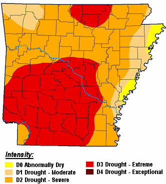
| In the picture: There was a moderate to extreme drought (D1 to D3) in much of Arkansas except the extreme east on 12/12/2017. |
| |
| By mid-December, a moderate to extreme drought (D1 to D3) developed in much of Arkansas. As of the 14th, there was a high wildfire danger, with burn bans posted in a whopping 70 (of 75) counties! |
 |
| In the picture: Seven day rainfall through 600 am CST on 12/23/2017. |
|
| |
|
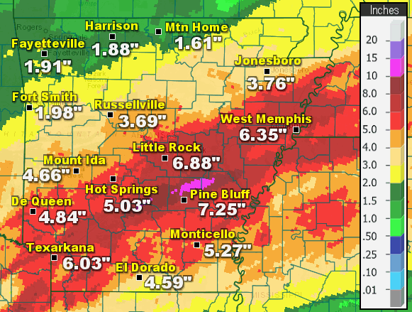
One of the wettest weeks of 2017 put a huge dent in the drought just before the year ended. The state was pounded with heavy rain from December 16th through the 22nd. Seven day totals through 600 am CST on the 23rd included 7.25 inches at Pine Bluff (Jefferson County), 6.88 inches at Little Rock (Pulaski County), 6.35 inches at West Memphis (Crittenden County), 6.03 inches at Texarkana (Miller County), 5.27 inches at Monticello (Drew County), and 5.03 inches at Hot Springs (Garland County).
After this episode ended, fires were not much of a concern. On the 24th, there was only one burn ban, and the wildfire danger was low.
|
| Significant Event #2: February 28-March 1 (Wind/Tornadoes) |
|
|
| |
|
The next big event happened in late February/early March. Isolated supercells (storms with rotating updrafts) erupted in central Arkansas toward evening on February 28th. Two tornadoes (rated EF1/EF2) were spawned near Higginson and Kensett (both in White County). According to the Arkansas Department of Emergency Management, at least half a dozen people were injured and taken to area hospitals.
There was a sizable lull in the late evening (several hours), but models were insistent on a line of storms sweeping into the region from Oklahoma. During the wee hours of March 1st, the line materialized and plowed across the northern half of the state. Storms reached Fort Smith (Sebastian County) by 100 am CST, and were in Blytheville (Mississippi County) by 430 am CST. That's roughly 250 miles in less than four hours! Along the way, trees and power lines were downed and structures were damaged or destroyed. Straight-line wind gusts reached 60 to more than 90 mph.
|
| Notable Gusts at Automated Observation Sites (03/01/2017) |
| Site |
Gust |
Time |
| Walnut Ridge (Lawrence Co) |
76 mph |
335 am CST |
| Jonesboro (Craighead Co) |
68 mph |
350 am CST |
| Fort Smith (Sebastian Co) |
66 mph |
1252 am CST |
| Newport (Jackson Co) |
66 mph |
332 am CST |
| Blytheville (Mississippi Co) |
63 mph |
429 am CST |
| Flippin (Marion Co) |
59 mph |
235 am CST |
| Corning (Clay Co) |
58 mph |
355 am CST |
 |
| In the picture: A trailer was flipped by powerful straight-line winds at a prison east of Newport (Jackson County) during the predawn hours of 03/01/2017. |
|
| |
|
Intense wind damage was found in several spots, including Hagarville (Johnson County), Fairfield Bay (Van Buren County), Drasco (Cleburne County), and a few miles east of Newport (Jackson County). At the latter location, two injuries resulted when a trailer flipped. There was an unconfirmed report of a 110 mph gust measured by a nearby resident.
|
| Not Your Typical Severe Storms |
|
As a line of storms cut a swath through northern Arkansas, wording in Severe Thunderstorm Warnings was ramped up to call attention to how dangerous conditions would become:
"Intense thunderstorm lines can produce brief tornadoes and widespread significant wind damage. Although a tornado is not immediately likely, it is best to move to an interior room on the lowest floor of a building. These storms may cause serious injury and significant property damage."
|
 |
| In the picture: At least eight tornadoes (rated EF0 to EF2) were spawned across five counties in northern and central Arkansas from the evening of February 28th through the early morning hours of March 1st, 2017. |
|
| |
|
Intense lines of storms like this one sometimes produce brief and weak tornadoes. During this event, at least six weak tornadoes (rated EF0/EF1) were counted. They were just south of Lamar (Johnson County), north of Center Ridge (Conway County), at Crossroads (Cleburne County), near Diaz (Jackson County), and close to Possum Grape (Jackson County).
|
| Significant Event #3: April 28-30 (Flooding/Tornadoes) |
 |
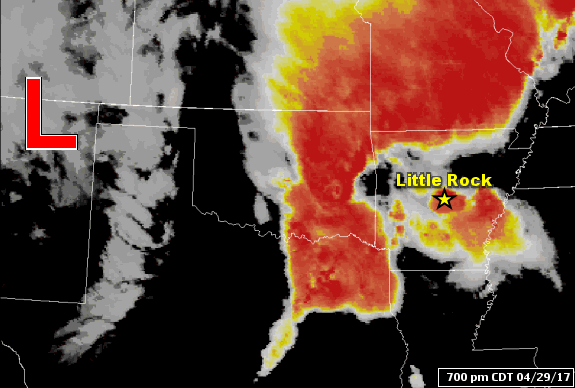
| In the picture: Flooding rain hinged on the placement of a warm front pushing through Arkansas from the south and the speed of a storm system ("L") approaching from the west on 04/29/2017. |
|
| |
|
The last big event occurred in late April. Conditions were looking very favorable for more than a half foot of rain in parts of Arkansas. The features to watch were a warm front lifting through the area from the south, and a storm system wobbling this way from the southern Plains.
|
|
|
| |
|
As the storm system to the west limped toward us, a wall of water slowly spread to the east. Not only was there a lot of rain, there was some severe weather.
|
|
|
| |
|
Just before 600 pm CDT, damaging straight-line winds knocked a tree onto a mobile home at DeWitt (Arkansas). A woman inside the mobile home was killed.
At least nine weak tornadoes (rated EF0/EF1) were confirmed. One of these tornadoes tore through locations near Bellefonte (Boone County) between 300 pm and 330 pm CDT on the 29th. The front of a house was pushed in, with serious damage resulting. Shortly before 500 pm CDT, another tornado damaged a home and destroyed a mobile home north of Natural Dam (Crawford County). Between 1230 am and 100 am CDT on the 30th, sheds and metal buildings were ripped up by a tornado a couple of miles north of Griffithville (White County). Huge trees were also uprooted or snapped. Other tornadoes were identified south of Augusta (Woodruff County), between Datto and Corning (both in Clay County), southwest of Humnoke (Lonoke County), near Happy Corners (Mississippi County), Dell (Mississippi County), and north of Pleasant Grove (Drew County). All of these happened during the wee hours of the 30th.
Power outages became a problem due to high winds and a tremendous amount of lightning. More than 70,000 customers lost power
|
|
|
| |
|
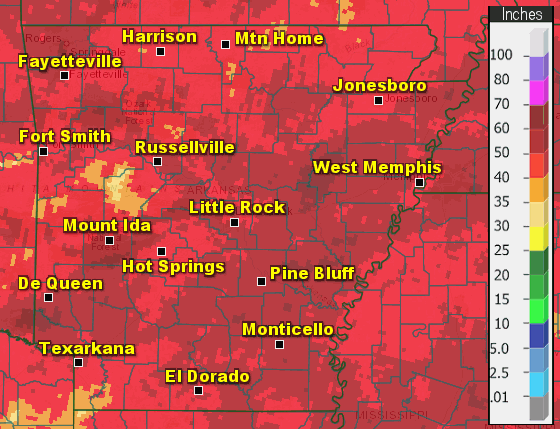
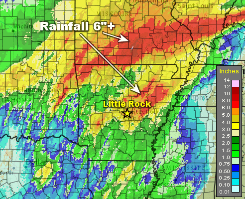
As far as reported rainfall, parts of the northwest and central into northeast sections of Arkansas were hammered with over six inches of rain. It was two months of rain in only a day.Twenty four hour amounts through 700 am CDT on the 30th included a whopping 9.73 inches near Rogers (Benton County), 8.50 inches at Savoy (Washington County), 7.85 inches at Guy (Faulkner County), and 7.82 inches at Georgetown (White County). Numerous roads were under water, with water into homes, and people rescued from houses and vehicles due to rising water.
At the North Little Rock Airport (Pulaski County), rain came down in buckets, and at a record pace. A staggering 1.55 inches of water fell 15 minutes, with 2.17 inches in 30 minutes.
|
|
At least seven people were killed as flooding became extreme. Near Hindsville (Madison County), a car carrying two small children (4-year-old boy and 18-month-old girl) was pushed off the road. Their bodies were eventually recovered. At Eureka Springs (Carroll County), a young woman was inner tubing in a drainage ditch and disappeared under a bridge. According to reports, her body was found a half mile downstream. A 10-year-old girl fell into a creek at Springdale (Washington County), and was swept downstream. Also in Washington County, the body an elderly man was found in a car that had been submerged in water. In West Little Rock (Pulaski County), a woman's body was discovered in Rock Creek. She was supposedly camping in a tent, and went missing when the water came up. Finally, northwest of Paron (Saline County), a group of people in kayaks were challenged by currents along Alum Fork south of Lake Winona. One man was killed.
|
 |
| In the picture: A record crest of 29.0 feet occurred along the Black River at Pocahontas (Randolph County) on 05/02/2017. |
|
| |
|
Given way more liquid than the ground could hold, area tributaries swelled heading into early May. Moderate to major flooding occurred along the Black, White, and Cache Rivers (northern and eastern Arkansas).
A record crest of 29.0 feet was reached along the Black River at Pocahontas (Randolph County) on May 2nd (breaking the previous record of 28.5 feet in late April, 2011). Prior to this unprecedented rise, evacuations were ordered on the east side of town, and Highway 67 was shut down.
|
| Not Just the Black River |
|
The Current River runs out of southern Missouri into northern Arkansas, and flows into the Black River just east (upstream) of Pocahontas (Randolph County). Twenty five miles away at Doniphan, MO, the Current River crested at 33.13 feet on May 1st. This was well above the previous high mark of 26.80 feet on March 1, 1904. The flow rate was an exceptional 183,000 cubic feet per second (CFS), dwarfing the usual trickle of 2,000 to 3,000 CFS. This tremendous and historic amount of water was injected into the Black River, and was a huge contributor to the flooding that occurred locally.
|
 |
Flooding at Pocahontas (Randolph County) | Flooding at Georgetown (White County)
Boating to Work from Georgetown (White County) |
| In the pictures: Pocahontas (Randolph County) and surrounding areas were inundated with water from an overflowing Black River (and failed levees along the river) on 05/03/2017. This is looking north from Walnut Ridge (Lawrence County). As the White River climbed steadily at Georgetown (White County), Highway 36 went under water. Because this was the only road out of town, people were forced to travel via boat. The photos are courtesy of Tracy Brengard (via Twitter), Ron Snyder (via Facebook), and Debra Lang (via Facebook) respectively. |
|
| |
|
On the 3rd, the river started dropping as a local levee failed in multiple spots. This led to imminent and widespread flooding in parts of Lawrence and Randolph Counties. A Flash Flood Emergency (mentioning "an extremely dangerous and life-threatening situation") was issued by the National Weather Service in Memphis, TN at 831 am CDT.
|
|
In the days to follow, the White River overflowed. At Georgetown (White County), a stretch of Highway 36 became a lake, and the town became an island. Extensive sandbagging took place at Des Arc (Prairie County) and Clarendon (Monroe County) to help keep some homes and businesses dry. According to the the University of Arkansas System Division of Agriculture, water engulfed more than 950,000 acres of cropland (in 21 of 75 counties), causing over $175 million in losses (especially to rice, soybeans, and corn).
Water drained very slowly (into an inflated Mississippi River), and minor to moderate flooding continued along the lower White River through early June.
|
| |
| There is more concerning the year 2017 in Arkansas. To check out the rest of the story, click here. |
|
|
|