 |
| About This Page |
| Arkansas has had its share of historic events, many of which will be in our memories for years to come. |
|
|
 |
Extremes in 2011: Heavy Snow/Severe Storms/Flooding/Heat |
 |
| |
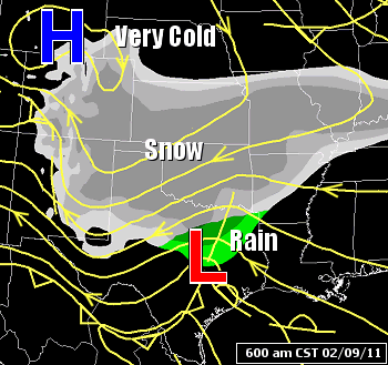 |
It was cold and snowy to begin 2011. While there were at least half a dozen significant snow events, the most memorable of these occurred on February 9th. It began with a storm system approaching from the southern Plains. Flakes started flying in northwest Arkansas before sunrise. |
| In the picture: A storm system ("L") tracked through Texas on 02/09/2011, and spread snow into Arkansas. The system was followed by arctic high pressure ("H") and much colder air. |
| Anywhere from four inches of snow up to a foot was common across much of the state, with one to more than two feet in the Ozark Mountains from Fayetteville (Washington County) to Jasper (Newton County) and Marshall (Searcy County). |
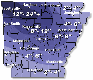 |
| In the picture: Snow accumulations on 02/09/2011. |
|
Huge snowfall amounts were reported in the northwest. At Siloam Springs (Benton County), 24.5 inches of snow piled up, with 24 inches at Hindsville (Madison County) and Springdale (Washington County).
These were close to the state record, but not quite. The greatest twenty four hour snowfall in Arkansas was 25 inches measured at Corning (Clay County) on January 22, 1918.
|
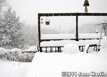 |
Near Jasper (Newton County), a foot of snow fell in three hours (between 530 am and 830 am CST). |
| In the picture: More than a foot of snow piled up around Jasper (Newton County) on 02/09/2011, and most of it fell in only three hours. The photo is courtesy of Jane Martin. Click to enlarge. |
| Heaviest Reported Snow Accumulations |
| Site |
Amount (Inches) |
| Siloam Springs (Benton Co) |
24.5 |
| Hindsville (Madison Co) |
24.0 |
| Springdale (Washington Co) |
24.0 |
| Rogers (Benton Co) |
22.0 |
| Huntsville (Madison Co) |
21.0 |
| Bentonville (Benton Co) |
20.0 |
| Ponca (Newton Co) |
19.5 |
| Fayetteville (Washington Co) |
18.0 |
| Jasper (Newton Co) |
15.0 |
| Deer (Newton Co) |
14.0 |
| Eureka Springs (Carroll Co) |
12.0 |
| Parthenon (Newton Co) |
12.0 |
| Gassville (Baxter Co) |
11.0 |
| Tilly (Pope Co) |
11.0 |
| Birdtown (Conway Co) |
10.0 |
| Clinton (Van Buren Co) |
10.0 |
| Gilbert (Searcy Co) |
10.0 |
| Harrison (Boone Co) |
10.0 |
|
This was a dry and powdery snow, with a snow to liquid ratio of 20 or 30 to 1 (0.1 inch of water equals 2.0 to 3.0 inches of snow). A heavy wet snow is closer to a 10 to 1 ratio, and does not accumulate as fast.
|
|
Interstate 540 north of Alma (Crawford County) was closed due to the snow and stalled traffic. Interstate 40 was also shut down for a period of time from just east of Little Rock (Pulaski County) to Lonoke (Lonoke County) after numerous tractor-trailers jackknifed.
There were three traffic fatalities on Interstate 40. A woman was killed along the highway when her vehicle got involved in an accident near Galloway (Pulaski County). Another accident claimed the lives of a woman and her one year old child near Brinkley (Monroe County).
Well below freezing temperatures made it easier for snow to accumulate on roadways. Travel was treacherous, and driving was not recommended to allow crews to treat the pavement.
|
| After snow tapered off during the afternoon and early evening hours of the 9th, the sky cleared. With snow on the ground and light winds, it was a perfect setup for a very cold night. Temperatures dipped well below zero in the northwest counties. |
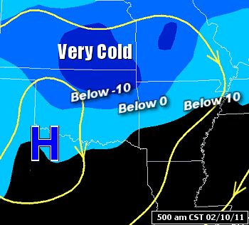 |
| In the picture: Arctic high pressure ("H") was over the southern Plains at 500 am CST on 02/10/2011. Under the high, it was very cold from northern Oklahoma into northwest Arkansas, with well below zero temperatures. |
|
The low temperature at Highfill (Benton County) was 21 degrees below zero, and 18 below zero at Fayetteville (Washington County). Nowata, OK plummeted to 31 degrees below zero. This broke the all-time state record of 27 below zero set at Vinita, OK on February 13, 1905. That same morning (in 1905), Gravette (Benton County) hit 29 below zero, the all-time Arkansas record.
Cold conditions spread farther east on the 11th. The day started with a low of 8 degrees at Pine Bluff (Jefferson County), the coldest February temperature since 1949. It was 4 degrees at Mena (Polk County) and 12 degrees at Hot Springs (Garland County), the coldest February readings since 1996 at both locations.
|
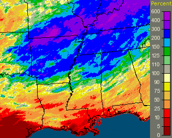 |
It went from winter to spring in a hurry once April arrived. There was way too much rain, and most of this occurred in the latter half of the month. It was a Top 5 wet April in Arkansas. |
| In the picture: Percent of normal rainfall in April, 2011. |
| More than a foot of precipitation fell across the north (at least 300 percent of normal) at sites such as Fayetteville (Washington County) and Harrison (Boone County). |
| Precipitation in April, 2011 |
| Site |
Amount |
Normal |
+/- |
% of Normal |
| Fayetteville (NW AR) |
15.28 |
4.33 |
+10.95 |
353% |
| Harrison (NC AR) |
14.73 |
4.10 |
+10.64 |
359% |
| Jonesboro (NE AR) |
8.15 |
4.99 |
+3.16 |
163% |
| Fort Smith (WC AR) |
9.55 |
3.91 |
+5.64 |
244% |
| Little Rock (C AR) |
7.23 |
5.47 |
+1.76 |
132% |
| West Memphis (EC AR) |
10.78 |
5.46 |
+5.32 |
197% |
| Texarkana (SW AR) |
5.94 |
3.95 |
+1.99 |
150% |
| El Dorado (SC AR) |
8.29 |
4.55 |
+3.74 |
182% |
| Pine Bluff (SE AR) |
13.26 |
5.14 |
+8.12 |
258% |
|
Area rivers and streams jumped, with record flooding on the Black River. As of 1100 am CDT on the 28th, the river at Corning (Clay County) was at 18.12 feet. This topped the 16.92 foot record established on June 13, 1945. The crest at Pocahontas (Randolph County) was 28.47 feet on the same day, which broke the previous high mark set in almost 100 years (27.90 feet on August 4, 1915). Dozen of residents were evacuated from their homes in town due to rising water and a breached levee.
|
| Not a Record For Long |
|
A very high Current River (running out of southern Missouri) helped push the Black River at Pocahontas (Randolph County) to 28.95 feet on May 3, 2017 (a new record).
|
| To add to this mess, a cold front pushed into the state from the north and stalled late on the 30th and into May 1st. Showers and thunderstorms focused along the front, and several inches of liquid dumped over the northern and central counties. |
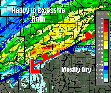 |
| In the picture: Forty eight hour rainfall through 1100 pm CDT on 05/01/2011. Precipitation was along and north of a front. |
|
Twenty four hour rainfall through 700 am CDT on May 1st included 8.70 inches at Morgan (Pulaski County), 7.14 inches at Lake Maumelle (Pulaski County), 6.71 inches near Cabot (Lonoke County) and 5.57 inches at the North Little Rock Airport (Pulaski County). Roads were closed and barricaded, homes flooded, and there were high water rescues.
This deluge and water headed downstream from the Black River guaranteed that historic levels were in store along the White River. On top of that, the river would be slow to drain because it emptied into an overflowing Mississippi River. In the end, record crests were established at Georgetown (White County) and Des Arc (Prairie County).
|
| Crests Along Black and White Rivers |
| Location |
River |
Flood Stage (ft) |
Crest (ft) |
Date |
| Corning (Clay Co) |
Black |
15 |
18.12R |
04/28/2011 |
| Pocahontas (Randolph Co) |
Black |
17 |
28.47R |
04/28/2011 |
| Black Rock (Lawrence Co) |
Black |
14 |
30.45 |
04/26/2011 |
| Newport (Jackson Co) |
White |
26 |
34.17 |
05/04/2011 |
| Augusta (Woodruff Co) |
White |
26 |
40.80 |
05/05/2011 |
| Georgetown (White Co) |
White |
21 |
33.95R |
05/06/2011 |
| Des Arc (Prairie Co) |
White |
24 |
39.43R |
05/07/2011 |
| Clarendon (Monroe Co) |
White |
26 |
37.54 |
05/10/2011 |
| Note: "R" is record crest. |
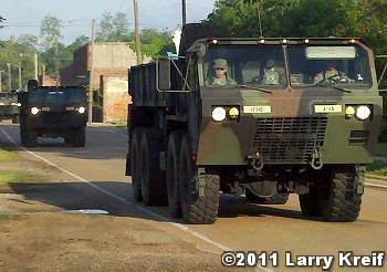 |
By the morning of the 2nd, emergency management advised people to leave along the White River at Des Arc and Biscoe (both in Prairie County). More evacuations took place in Jacksonport (Jackson County) by evening. On the 5th, evacuations were ordered at Gregory, McClelland and Cotton Plant (all in Woodruff County) due to overtopping of a levee along the White River and a swollen Cache River. |
| In the picture: The National Guard arrived in Cotton Plant (Woodruff County) on 05/06/2011 following evacuation orders for the town. The photo is courtesy of Larry Kreif. Click to enlarge. |
|
Travel was also affected. U.S. Highway 67/167 was closed between Sherwood and Jacksonville (Pulaski County) through the 3rd/early on the 4th. Water from the White River was over U.S. Highway 70 at DeValls Bluff (Prairie County), and also over Highway 36 at Georgetown (White County). At the latter location, there was no way out of town, and residents were cut off from the rest of the world.
On the 4th, the White River was high enough to close the westbound lanes of Interstate 40 in eastern Prairie County (at mile marker 202). The eastbound lanes were closed by the evening of the 5th. Traffic was diverted onto surrounding highways to avoid flooding. The detours involved 50 to 100 miles of extra driving.
Unfortunately, this high water episode claimed several lives. One fatality around Mayflower (Faulkner County) was the result of a vehicle overtaken by flood waters on May 1st along Arkansas State Highway 89. Another person disappeared on the 1st near Des Arc (Prairie County), but was found on the 4th (a drowning death). Other victims drove their vehicles into flooded highways in Cross, Greene, Lonoke and Randolph Counties (from May 3 through the 14th).
|
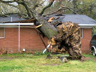 |
| In the picture: A large tree was blown onto a house in Pine Bluff (Jefferson County). Click to enlarge. |
|
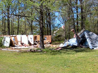 |
| In the picture: A mobile home was destroyed near Glendale (Lincoln County). Click to enlarge. |
|
| |
|
Before rivers became a problem, there was a massive amount of severe weather. On April 4th, a damaging wind event unfolded in southern Arkansas. Straight-line winds downed numerous trees and power lines, snapped power poles and caused structural damage.
Roads were blocked by trees, and a home was badly damaged at Gurdon (Clark County). Similar reports were received by the National Weather Service from Leola (Grant County), Pine Bluff (Jefferson County), and Star City (Lincoln County). At DeWitt (Arkansas County), a tree was pushed over onto a vehicle.
|
| What About the Hail? |
|
Of the roughly three dozen reports of hail at least two inches in diameter (hen egg size) in 2011, twenty eight of these were in April and May (especially from April 19th through the 26th). The largest stone was the size of a softball at Van Buren (Crawford County) on April 26th.
|
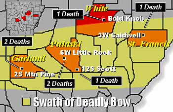
| Late on the 14th/early on the 15th, a powerful bow echo (backward C shaped line of storms) crossed the region. The storms were most destructive in the middle of the night (mostly between 100 am and 400 am CDT on the 15th). This is the most dangerous time for severe weather when awareness generally drops because most folks are asleep. Seven (7) people were killed, including three (3) children. Most of the deaths were the result of trees falling on structures. |
|
| In the picture: While there were several bowing segments early on 04/15/2011, one dominant bow was responsible for most of the destruction during this event. The bow traversed the central third of Arkansas. |
|
There were isolated tornadoes spawned. Winds turned with height, and Tornado Warnings were issued. Ten (10) tornadoes were confirmed (rated EF1/EF2) in the Little Rock County Warning Area.
|
| Tornado/Damaging Wind/Flood Fatalities |
|
Across Arkansas, at least 35 people were killed by high water (17 deaths), damaging winds (6 deaths), and tornadoes (12 deaths) in April and May.
|
|
|
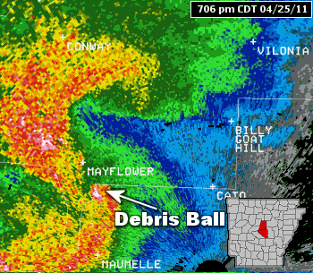
On the 25th, a tornado outbreak affected areas from southwest into central Arkansas. Eighteen (18) tornadoes were identified (rated EF0 to EF3). |
| In the pictures: The WSR-88D (Doppler Weather Radar) showed a tornado storm heading rapidly toward Vilonia (Faulkner County) from the southwest between 700 pm and 730 pm CDT on 04/25/2011. In the hook portion of the storm, a "debris ball" is noted (circular area of white and pink colors). This signature usually indicates that damage has occurred (i.e. structures hit) by a tornado. |
|
One of the strongest of these hit the community of Vilonia (Faulkner County) around 725 pm CDT. The tornado was responsible for major structural damage, and four fatalities (at a mobile home park southwest of town). This tornado (rated EF2) was long-lived, lasting just over 51 miles and ripping through three counties (Pulaski, Faulkner and White).
|
| Record Width in Arkansas |
|
The Vilonia (Faulkner County) was not only noted for its long track (51 miles), it had a width of 2900 yards or close to 1.65 miles. This is the widest track on record in the state (since 1950).
|
|
There were three tornadoes in Garland County alone, with one of the tornadoes claiming the life of an 8 month old boy (who died from his injuries several days after the storm). Another tornado cut through Hot Springs Village (Garland County). As a warning for this particular tornado was issued, a youth service for 60 children was in progress at Fountain Lake (Garland County). Everyone was evacuated from the church when the warning was received on NOAA Weather Radio All Hazards.
|
| North of Jacksonville (Pulaski County), there was extensive roof damage to the North Pulaski High School auditorium. Brick walls on the back end of the school collapsed. Three aircraft were damaged at the Little Rock Air Force Base, and numerous housing units were flattened and destroyed. |
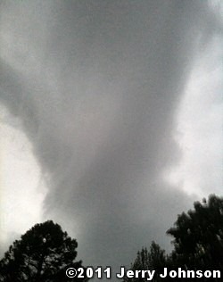 |
| In the picture: A tornado (rated EF2) was captured near Gravel Ridge (Pulaski County) just off of Highway 107 on 04/25/2011. A short time later, the tornado tracked through the Little Rock Air Force Base (Pulaski County). The photo is courtesy of Jerry Johnson. Click to enlarge. |
| How Many Tornadoes? |
|
There were a whopping 56 tornadoes counted across Arkansas in April and 11 tornadoes in May. The yearly total was 75 tornadoes. This was the fourth most on record in the state (1999: 107 tornadoes, 2008: 81 tornadoes, 1982: 78 tornadoes).
|
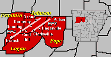 |
Just after midnight CDT on May 25th, a line of storms was barreling through western Arkansas. Ahead of the line, an isolated storm began to rotate. Before long, there was a powerful tornado (rated EF4) at Denning (Franklin County). |
| In the picture: Two tornadoes (rated EF3/EF4) were confirmed early on 05/25/2011. |
|
The tornado tore through areas just north of Coal Hill before striking Harmony and Ozone (all in Johnson County). The tornado was on the ground for 46 miles, and was one of only three tornadoes rated this strong across the state since 2000 (through 2020). The tornado claimed four lives (three in Franklin County and one in Johnson County).
Another cranked up around Clarksville (Johnson County) and headed to areas just northwest of Hagarville (Johnson County). This tornado (rated EF3) killed one person in the Strawberry community.
|
| Outside of Arkansas |
|
On May 22nd, a catastrophic tornado (rated EF5) knifed its way through the heart of Joplin, MO and killed 158 people. It was the costliest tornado in U.S. history, and a Top 10 deadly tornado nationally. The other nine tornadoes mostly occurred before radar and warnings existed (prior to 1955).
There was a super outbreak of tornadoes on April 27th. More than 200 tornadoes were spawned (including four rated EF5), with the bulk of these in Alabama, Georgia, Mississippi, and Tennessee. It was a record number of tornadoes across the country in a twenty four hour period. Altogether, there were 317 fatalities (249 deaths in Alabama).
|
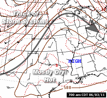
| Rain shut off in the summer, and a ridge of high pressure was a frequent visitor. Under the ridge, temperatures heated up and there was not much rain. Looking at data since 1895, it tied for the hottest summer on record (with 1934 and 1954) with an average temperature of 83.2 degrees (4.5 degrees above average). |
|
| In the picture: A ridge of high pressure ("HIGH") was over Arkansas on 06/03/2011. Clockwise flow around the high drove storm systems and fronts well to the north of the state, leaving the region hot and mostly dry. |
|
The thermometer at Fort Smith (Sebastian County) reached at least 100 degrees an astonishing 48 times from June through August. That was the third most in recorded history locally (53 times in 1934 and 49 times in 1954). During the same time frame, highs were 90 degrees or above and lows were at or above 70 degrees on 84 of 92 days at Little Rock (Pulaski County). While both numbers were surpassed in 2010 (87 times for highs/lows), it did not happen in prior years dating back into the 1870s.
The heat was extreme in early August. Record high temperatures were noted every day from the 1st through the 8th. The hottest day was the 3rd, with all-time records set at several locations.
|
|
This included Fort Smith (Sebastian County) with a high of 115 degrees and Little Rock (Pulaski County) not far behind at 114 degrees. Very dry air/low dewpoints in the afternoon allowed the mercury to soar.
|
| Record Heat on August 3, 2011 |
| Site |
High Temp |
Lowest Dewpoint/RH |
Highest Heat Index |
| Fayetteville (NW AR) |
110°! |
59°/20% |
110° |
| Harrison (NC AR) |
112°! |
56°/17% |
109° |
| Mountain Home (NC AR) |
114° |
57°/17% |
112° |
| Jonesboro (NE AR) |
107° |
72°/33% |
119° |
| Fort Smith (WC AR) |
115°! |
50°/11% |
113° |
| Little Rock (C AR) |
114°! |
61°/18% |
120° |
| West Memphis (EC AR) |
105° |
75°/40% |
120° |
| Mount Ida (WC AR) |
112° |
62°/21% |
112° |
| Hot Springs (C AR) |
108° |
64°/25% |
112° |
| Pine Bluff (SE AR) |
110° |
67°/26% |
117° |
| Texarkana (SW AR) |
111° |
63°/21% |
113° |
| El Dorado (SC AR) |
108° |
66°/27% |
113° |
| Monticello (SE AR) |
107° |
69°/31% |
115° |
| Note: "!" is all-time record high temperature. Temperatures were hottest in western Arkansas as the atmosphere dried out (relative humidity dropped). Heat index values were highest in the east where humidity levels stayed up. |
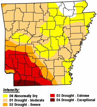 |
Heat and a lack of precipitation led to a widespread drought. Conditions were the worst in the southwest. By the end of October, rainfall at El Dorado (Union County) and Texarkana (Miller County) was close to eighteen inches below normal. |
| In the picture: A severe to exceptional drought was noted in southwest Arkansas on 11/01/2011. |
|
|