|
The Palm Sunday, March 28, 2010, Severe Thunderstorm Outbreak
A tornado moves along Interstate 85 at exit 85 near Linwood, North Carolina, on Palm Sunday, 28 March 2010. The tornado initially touched down in Spencer, North Carolina. Image taken by Jonna Bingham, courtesy of WCNC-TV Charlotte, and used by permission. Author's Note: The following report has not been subjected to the scientific peer review process.
1. Introduction
In the late afternoon and evening of Palm Sunday, 28 March 2010, numerous
severe thunderstorms developed over the Foothills and Piedmont of the
Carolinas.  The most significant of the storms strengthened over Gaston
County, North Carolina, after 5 pm Eastern Daylight Time (EDT), and
produced a tornado near Belmont at 537 pm EDT (2137 UTC).  The tornado
struck the Park Dale Mill, damaging the metal roof of the mill building
and overturning a tractor-trailer, and then moved over an adjacent mobile
home park before lifting seconds later.  The storm went on to produce
straight-line wind damage over western Mecklenburg County, North Carolina,
while it quickly acquired supercell thunderstorm characteristics.  The
supercell continued to move off to the northeast and spawned a second
tornado which began in Spencer, North Carolina, at 645 pm EDT (2245 UTC).
The tornado damaged a shopping center on North Salisbury Avenue and moved
over the east side of town, producing tree and roof damage to several
homes.  The tornado remained on the ground and crossed Interstate 85
before crossing the Yadkin River into Davidson County at 649 pm EDT.  The
damage from both tornadoes was rated at EF1 intensity on the Enhanced
Fujita Scale.  No other tornadoes were reported from subsequent storms
across the county warning area (CWA) of the Greenville-Spartanburg (GSP)
National Weather Service (NWS) office, although several produced hail
larger than quarters.
[Note: All times in this report from this point forward are expressed in Universal Time Coordinated (UTC), which is EDT plus four hours. To convert from UTC to EDT, subtract four hours from the UTC time.]
Click here to view a list of wind damage and hail reports on 28 March 2010

Figure 1.  Preliminary reports of tornadoes, wind damage, and hail
received during the 24 hours ending at 1200 UTC on 29 March 2010.  Click
on image to enlarge.
The events of 28 March were not unprecedented as several notable severe thunderstorm and tornado outbreaks have occurred in late March. Weather forecasters have come to expect a big severe weather event across the Carolinas in early Spring. Nor were the events of 28 March unanticipated. As early as the early morning hours of 27 March, the NWS expected strong deep layer wind shear to be present across the Piedmont of the Carolinas on 28 March, as noted by the Storm Prediction Center (SPC) in the Day 2 Severe Weather Outlook. Subsequent outlooks issued in the afternoon of 27 March and in the early morning hours of 28 March continued to highlight the threat for supercell thunderstorms and tornadoes in the afternoon and evening of 28 March, if enough instability could be realized.
2. Synoptic Overview
On the morning of 28 March, the upper air analysis at 1200 UTC showed a closed low at 500 mb centered near St. Louis, Missouri, and a trough axis extending back across the southern Plains (Fig. 2). Of note was a mid-level jet streak of 90 to 95 kt winds observed across central Alabama and central Mississippi. A belt of strong winds, on the order of 50 to 55 kt, also appeared on the 700 mb analysis (Fig. 3) from central Alabama west across southern Mississippi and Louisiana. The 850 mb analysis (Fig. 4) showed a southwesterly low-level jet of 40 to 50 kt extending from Alabama and Georgia to the Ohio River Valley. The mid-level jet streaks at 500 mb and 700 mb were expected to move over the top of the low-level jet at 850 mb as it translated east, contributing to an increase in deep-layer wind shear across the western Carolinas later in the day. 
Figure 2. Objective analysis of 500 mb geopotential height (black contours), temperature (red dashed contours), and wind barbs at 1200 UTC on 28 March 2010. Click on image to enlarge. 
Figure 3. Objective analysis of 700 mb geopotential height (black contours), temperature (red and blue dashed contours), dewpoint (green contours), and wind barbs at 1200 UTC on 28 March 2010. Click on image to enlarge. 
Figure 4.  Objective analysis of 850 mb geopotential height (black
contours), temperature (red and blue dashed contours), dewpoint (green
contours), and wind barbs at 1200 UTC on 28 March 2010.  Click on image
to enlarge.
The surface analysis from the Hydrometeorological Prediction Center (HPC) showed an occluded low pressure center near the confluence of the Ohio and Mississippi Rivers (Fig. 5). The occluded front extended southward across western Kentucky and western Tennessee, with a cold front from northeast Mississippi to southeast Louisiana. High pressure was centered over Newfoundland. Although it was not analyzed, there was evidence of a weak surface boundary stretching across the northern part of Upstate South Carolina and running southwest to northeast across the Foothills of North Carolina. Surface observations taken around 1200 UTC (Fig. 6) showed a wind shift between a northerly component at Rutherfordton (FQD) and North Wilkesboro (UKF), and an easterly to southeasterly wind across most of South Carolina and the eastern half of North Carolina. The air mass on the north side of the boundary resembled a cold air damming wedge, albeit smaller in coverage than the usual wedge. This boundary would play an important role in the development of severe weather later in the day. 
Figure 5. HPC Surface fronts and pressure analysis at 1200 UTC on 28 March. Click on image to enlarge. 
Figure 6.  Surface observations plot for 1200 UTC 28 March, using the
traditional station model.  A quasi-stationary boundary has been analyzed
and displayed using traditional front symbols.  Click on image to enlarge.
The upper air sounding taken at Birmingham, Alabama (BMX, Fig. 7), was perhaps the most indicative of the conditions expected to occur over the western Carolinas and northeast Georgia late in the day. The sounding showed the strong shear (65 kt) and storm relative helicity (SRH, 468 m2s-2) in the layer from the surface to 3 km that was supportive of rotating updrafts. However, the sounding only yielded a convective available potential energy (CAPE) of around 600 J kg-1 when modified for forecast surface temperature. The combination of strong shear and modest buoyancy warranted a slight risk of severe thunderstorms in the Day 1 Convective Outlook update issued by the SPC at 1300 UTC. 
Figure 7.  Skew T, log P diagram for upper air sounding taken at BMX
at 1200 UTC on 28 March.  A hodograph is shown in the upper right corner
and a table of convective parameters is provided at the bottom.  Click
on image to enlarge.
An initial band of showers across northeast Georgia, the western tip of South Carolina, and western North Carolina at 1200 UTC (Fig. 8) moved slowly northeast through 1800 UTC, as seen on a loop of a regional radar mosaic. The light rain showers may have strengthened the pre-existing weak cold air damming wedge across western North Carolina and northern South Carolina. Surface observations at 1800 UTC showed light rain, a north wind, and temperatures in the mid-40s to low-50s at Hickory (HKY) and GSP, while temperatures were in the low-60s with a south wind at Anderson (AND), Charlotte (CLT), and Salisbury (RUQ). The observations supported the analysis of a weak surface boundary running across the northern part of Upstate South Carolina and the western Piedmont of North Carolina (Fig. 9). 
Figure 8. Composite reflectivity mosaic centered on GSP at 1200 UTC on 28 March. Click on image to enlarge. 
Figure 9.  HPC regional surface analysis at 1800 UTC on 28 March.
Click on image to enlarge.
Destabilization was slow to occur due to extensive cloud cover during the morning hours, seen on a loop of visible satellite imagery, but enough breaks occurred for some surface-based CAPE to develop by midday. The Day 1 Convective Outlook update, issued by the SPC at 1626 UTC, highlighted the developing buoyancy and wind shear. Water vapor imagery showed evidence of the mid-level jet streak moving to the south of the upper low seen over western Kentucky, as indicated by the stripe of warmer brightness temperatures as the result of subsidence across the middle of Mississippi and Alabama. As expected, the jet streak dramatically increased the deep layer shear across the region, thus by the middle part of the afternoon it appeared likely that severe thunderstorms would occur as discussed by the SPC at 1921 UTC. An increase in convective development to the lee of the Appalachians prompted the issuance of a Tornado Watch (#0037) at 1951 UTC.
3. Pre-Storm Environment
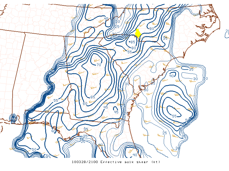
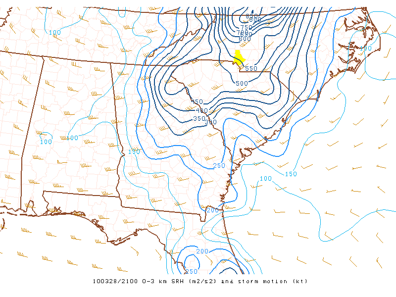
In the 2000 UTC to 2100 UTC time frame, convection loosely organized into bands across Georgia and the Carolinas (Fig. 10). One band stretched from the west side of the Charlotte metro area to the west side of Augusta, Georgia, at 2100 UTC. The environment was highly supportive of rotating updrafts and supercell thunderstorms. At 2100 UTC, by most measures, wind shear and SRH were large. Effective bulk shear (Fig. 11a) of greater than 50 kt stretched generally along the surface boundary at 2100 UTC, with a maximum of 65 kt to the southwest of Charlotte. The SRH in the surface to 3 km layer (Fig. 11b) was greater than 450 m2s-2 across all of Upstate South Carolina and the Foothills and Piedmont of North Carolina, with a contour of 550 m2s-2 across the Charlotte area. Shear in the 0-1 km layer (Fig. 11c) was on the order of 40 kt along the boundary. The SRH in the layer from the surface to 1 km (Fig. 11d) was in excess of 400 m2s-2. This suggested a relatively high probability for tornado-producing supercells. The mean height of the lifting condensation level (LCL) in the lowest 100 mb (Fig. 11d) was between 500 m and 750 m above ground level. The surface boundary was particularly apparent in the analysis of effective inflow base (Fig. 12), which suggested the elevated nature of convective cells to the north of the boundary and how cells to the south of the boundary were rooted in the boundary layer. A sharp gradient of effective SRH was located on the warm side of the boundary with a maximum of 500 m2s-2 on the east side of Charlotte. Surface-based CAPE reached approximately 500 J kg-1 on the west side of Charlotte by 2100 UTC, with no convective inhibition (CIN; Fig. 13). Although modest, the amount of buoyancy was enough to maintain deep convection as it moved over the Charlotte metro area after 2100 UTC. 
Figure 10.  As in Fig. 8, except for 2059 UTC on 28 March.  Click on
image to enlarge.
Figure 11. SPC objective mesoscale analysis at 2100 UTC on 28 March showing (A) effective bulk shear (kt; blue contours) and storm motion (barbs), (B) SRH in the 0-3 km layer (m2s-2; blue contours) and storm motion (barbs), (C) shear in the 0-1 km layer (kt; blue contours), and (D) SRH in the 0-1 km layer (kt; blue contours), 100 mb mean lifting condensation level (m; dashed green contours) and storm motion (barbs). Mecklenburg County (Charlotte), North Carolina, is shaded yellow for reference. Click on images to enlarge. 
Figure 12. SPC objective mesoscale analysis at 2100 UTC on 28 March showing effective inflow base (m; color fill) and effective SRH (m2s-2; blue contours). Mecklenburg County (Charlotte), North Carolina, is shaded yellow for reference. Click on image to enlarge. 
Figure 13.  SPC objective mesoscale analysis at 2100 UTC on 28 March
showing surface based CAPE (J kg-1; brown contours) and surface based
CIN (J kg-1; color fill).  Mecklenburg County (Charlotte), North Carolina,
is shaded yellow for reference.  Click on image to enlarge.
After 2100 UTC, the convection was poised to move northeast in close proximity to the wedge boundary, through an environment with a low LCL and rich with low level shear and helicity. Most objective criteria supported a threat for supercell thunderstorms with the possibility of tornadoes (Fig. 14).
Figure 14.  SPC objective mesoscale analysis at 2100 UTC on 28 March
showing (a) Craven Significant Severe Parameter (index; blue and magenta
contours), (b) 3 km Energy-Helicity Index (index; green and brown contours),
(c) Supercell Composite Parameter (index; light blue contours) and Bunkers
storm motion (kt; barbs), and (d) Significant Tornado Parameter (index;
orange and red contours) and mixed layer CIN (J kg-1; color fill).
Mecklenburg County (Charlotte), North Carolina, is shaded yellow for
reference.  Click on images to enlarge.
4. Convective Evolution
An isolated severe thunderstorm (the first of the day) occurred between
2000 UTC and 2100 UTC, producing hail up to the size of golf balls in the
Mooresville, North Carolina area.  Between 2100 and 2300 UTC, convection
gradually increased in coverage and intensity over the GSP CWA, with
severe thunderstorms becoming more numerous.  Although severe weather
during this time was mainly limited to large hail ranging from quarter
to golf ball size, two tornadoes occurred across the North Carolina
Piedmont: one in the Belmont area of Gaston County, and another that began
in Spencer in Rowan County.  We will focus closely on these two tornadoes
through the remainder of this section.
Click here to view a 26 frame loop of base reflectivity on the 0.5 degree elevation scan from the KGSP radar from 2103 UTC to 2259 UTC. Click here to view a 26 frame loop of storm relative motion on the 0.5 degree elevation scan from the KGSP radar from 2103 UTC to 2259 UTC. a. The Belmont Tornado The convective cell that spawned the Belmont tornado moved into southwest Gaston County from South Carolina around 2108 UTC (Fig. 15). At this point, the Belmont storm had a slight cyclonic curvature at the 0.5 degree elevation slice from the NWS Doppler radar located at the GSP airport (the KGSP radar). There was also echo overhang on the storm’s right flank, indicative of a strong updraft. However, the high reflectivity core (greater than 50 dBz) extended only to about 16 kft. Higher elevation slices from KGSP revealed an echo top of around 30 kft. In addition, the width of the storm core in the mid-levels was only two to three miles. The cyclonic curvature and echo overhang, along with the shallow and small nature of this cell, was suggestive of a mini-supercell. However, examination of the storm relative velocity (SRV) at this time (Fig. 16) revealed only a broad, divergent area of cyclonic shear on the 1.3 degree elevation slice, which was sampling the storm at about 10 kft MSL. Rotational shear associated with this feature was only 3.2 x 10⁻³ s-1, which does not qualify it as a "minimal mesocyclone" according to the Rotational Shear Nomogram. Therefore, while the storm exhibited some supercell-like characteristics, the absence of a mesocyclone eliminated it as a mini- supercell candidate at this point in time. It was also important to note that based on the thermodynamic character of the environment, the storm did not meet objective Severe Thunderstorm Warning criteria at this time due to the fact that it was unlikely to produce large hail given the limited vertical extent of the high reflectivity core. Indeed, no severe weather was reported with this storm as it moved over southwest and central Gaston County. 
Figure 15. Four-panel display of base reflectivity from the KGSP radar at (a) 0.5 degrees, (b) 1.3 degrees, (c) 2.4 degrees, and (d) 3.4 degrees elevation at 2108 UTC on 28 March. Rainfall intensity is given by the color table at the upper left of each figure. Click on image to enlarge. 
Figure 16.  Four-panel display of storm relative motion from the KGSP radar
at (a) 0.5 degrees, (b) 1.3 degrees, (c) 2.4 degrees, and (d) 3.4 degrees
elevation at 2108 UTC on 28 March.  Motion toward or away from the radar
is given by the color table at the upper left of each figure, where warm
colors are motion away from the radar and cool colors show motion toward
the radar.  Click on image to enlarge.
The lowest four elevation slices of base reflectivity from KGSP at 2126 UTC showed persistent echo overhang as well as cyclonic curvature (Fig. 17). The right-flank appendage became elongated in a north/south orientation. The images also revealed a line of scattered convective cells intersecting the appendage and extending to the southwest. The surface observations overlaying the 0.5 degree elevation scan suggested that these cells were oriented roughly parallel and just behind (i.e., in the cool sector of) the synoptic surface boundary. 
Figure 17. As in Fig. 15, except at 2126 UTC. Click on image to enlarge. The narrower beam width of the Terminal Doppler Weather Radar (TDWR) near Charlotte, North Carolina (TCLT), and its closer proximity to the cell offered an opportunity for a more detailed analysis of the storm (Fig. 18). The reflectivity image showed the elongated appendage extending from the "main" cell over east-central Gaston County. From the TDWR’s perspective, the storm system appeared to have a quasi-linear, as opposed to single- cellular, appearance, especially at the 1.0 degree and 2.4 degree elevation angles. 
Figure 18.  Four-panel display of base reflectivity from the TCLT radar at
(a) 0.2 degrees, (b) 1.0 degrees, (c) 2.4 degrees, and (d) 5.0 degrees
elevation at 2126 UTC on 28 March.  Rainfall intensity is given by the
color table at the upper left of each figure.  Click on image to enlarge.
The SRV data from TCLT at 2126 UTC (Fig. 19) did not reveal anything too enlightening. However, there was a broad, weak zone of cyclonic shear associated with the elongated appendage. This was especially evident at 2.4 degrees. Meanwhile, surface observations indicated the storm system was located just on the cool side of the frontal boundary (denoted by the red line) at this time. Since analyses indicated that no CAPE existed on the cool side of the boundary (Fig. 9), it was unlikely that this cell was surface-based. 
Figure 19.  Same as in Fig. 18, except for Storm Relative Velocity.  Click
on image to enlarge.
By 2132 UTC, the storm system was exhibiting interesting structure (Fig. 20). A slight bulge and rear-inflow notch was evident in the middle of the appendage at 0.2 degrees. There was also a subtle cyclonic curvature of the 40-45 dBz echo at the southern end of the appendage at the 5.0 degree elevation slice. The storm relative velocity image at this time (Fig. 21) indicated this curvature was associated with an area of cyclonic rotation. Rotational shear was calculated at 1.33 x 10⁻² s-1, placing this couplet in the "tornado possible" category of the rotational shear nomogram. However, the velocity couplet was not evident below 5.0 degrees. Meanwhile, there was a weak area of inbound velocity along the back edge of the high reflectivity at 5.0 degrees. This was above the bulging segment seen in the reflectivity field in lower levels, and may be indicative of a descending air current (i.e., a rear-flank downdraft [RFD]). Velocities were weak due to the fact that the RFD would have a strong cross-radial component. 
Figure 20. Same as in Fig. 18, except at 2132 UTC. Click on image to enlarge. 
Figure 21.  Same as in Fig. 19, except at 2132 UTC.  Click on image to
enlarge.
This circulation intensified and descended after 2132 UTC, as revealed in the time-series of rotational shear shown in Fig. 22. By 2134, the circulation became evident at the 0.2 degree elevation scan. At 2135 UTC, values of rotational shear were marginally within the "Tornado Probable" category of the nomogram. This was only a minute or two before a tornado touched down on the southeast side of Belmont. After 2135 UTC, the circulation intensified rapidly. Unfortunately, due to the 3 to 6 minute resolution of the higher elevation scans of the TDWR, data were only available at 0.2 degrees during the brief time the tornado was on the ground. The reflectivity and SRV at the time of the tornado (2137 UTC) showed a hook echo and associated small (~0.5 km diameter), but intense circulation in the vicinity of the tornado (Fig. 23). Although the actual velocities were not that high (39 kt outbound and 14 kt inbound), the very small diameter of the couplet is resulting in rotational shear of 4.8 x 10⁻² s-1. This value was actually "off the chart" with respect to the rotational shear nomogram, suggesting a tornado was likely imminent or already occurring. 
Figure 22. Time series of rotaional shear of the Belmont tornadic storm as calculated from TCLT between 2129 UTC and 2141 UTC. The time of the tornado (red line) and downburst occurrence (light blue line) are marked along the X-axis. Click on image to enlarge. 
Figure 23.  TCLT base reflectivity (a) and storm relative velocity (b) at
2137 UTC on 28 March.  The location of the damage produced by the Belmont
tornado is indicated by the white triangle.  Click on image to enlarge.
The 2138 UTC volume scan (Fig. 24) revealed the presence of the hook echo through the lowest four elevation slices. In fact, high reflectivity had almost wrapped completely around the circulation at the 2.4 degree and 5.0 degree slices. Although the circulation weakened in the lower levels after the tornado dissipated (Fig. 22), it and the hook echo persisted for approximately 30 minutes after the tornado dissipated (not shown). Nevertheless, an NWS storm survey indicated that the tornado dissipated before moving into Mecklenburg County, with the parent storm evolving into a downburst-producer. 
Figure 24.  Same as in Fig. 18, except at 2138 UTC.  Click on image to
enlarge.
The circulation developed rapidly as the shear zone moved across the surface boundary. As the storm crossed the boundary, it would have ingested and tilted air that was rich in horizontal vorticity. In addition, it would have experienced more unstable air and enhanced low-level convergence. Indeed, there was a notable increase in updraft strength over eastern Gaston County at the time of the tornado, suggested by an increase in Vertically Integrated Liquid on the 2140 UTC scan. This suggested that in addition to tilting of the horizontal vorticity that existed along the boundary, vortex tube stretching within the updraft likely played a key role in tornadogenesis as well. Despite the elongated appearance of this storm system in TDWR reflectivity data, the presence of a cyclonic circulation in the mid-levels of the storm (i.e., around 10 kft) prior to tornadogenesis suggested supercellular processes were at play. b. The Spencer Tornado As the storm that produced the Belmont tornado moved across Mecklenburg County, it generally maintained its intensity in terms of the depth of the storm. However, other than the downburst that occurred across western Mecklenburg County subsequent to the dissipation of the Belmont tornado, no additional severe weather was reported with the storm as it moved across northern Mecklenburg County and northwest Cabarrus County into southwest Rowan County. However, the storm underwent a significant intensification as it moved into central Rowan County. During this time, the high reflectivity core developed to over 20 kft (Fig. 25), while the storm top extended to over 40 kft. This was accompanied by a substantial increase in mid-level rotation (Fig. 26). Images from TCLT showed the supercellular character of the storm during this time. The reflectivity images revealed an appendage extending southeast from the main core of the cell (Fig. 25). A large weak echo region (WER) was observed at the lower elevation slices, topped by a high reflectivity core in the mid-levels (around 14 kft). 
Figure 25. Four-panel display of base reflectivity from the TCLT radar at (a) 1.0 degrees, (b) 2.4 degrees, (c) 5.0 degrees, and (d) 7.7 degrees elevation at 2232 UTC on 28 March. Rainfall intensity is given by the color table at the upper left of each figure. Click on image to enlarge. 
Figure 26.  Same as in Fig. 25, except for Storm Relative Motion at
2232 UTC.  Click on image to enlarge.
TCLT images from 2244 UTC (Fig. 27 and Fig. 28) revealed the impressive structure of the mini-supercell minutes prior to tornadogenesis. The appendage observed at 2232 UTC evolved into a pronounced hook echo. The "hole" in reflectivity at the 2.4 degree elevation scan (above the weak reflectivity region on the 1.0 degree scan) was topped by an area of high reflectivity (greater than 50 dBz) at 5.0 degrees, indicating the presence of a bounded weak echo region (BWER). The SRV data at this time (Fig. 28) did not reveal a rotational couplet, owing to range folding in the region of the BWER. However, there was an area of intense (60 kt or more) outbound velocities associated with the hook echo. 
Figure 27. Same as in Fig. 25, except at 2244 UTC. Click on image to enlarge. 
Figure 28. Same as in Fig. 26, except at 2244 UTC. Click on image to enlarge. At 2250 UTC, the tornado was in progress. By this time, it had likely exited the GSP CWA and was just inside the Davidson County border. TCLT reflectivity imagery revealed a persistent hook echo and BWER (Fig. 29). However, the SRV data was most impressive at this time, especially at the 2.4 degree slice, where a gate-to-gate circulation of around 90 kt was evident (Fig. 30). 
Figure 29. Same as in Fig. 25, except at 2250 UTC. Click on image to enlarge. 
Figure 30. Same as in Fig. 26, except at 2250 UTC. Click on image to enlarge. One question that emerged from this case study was why there was such a long duration (i.e., more than an hour) between the two tornado events produced by this single mini-supercell. The surface analysis at 2200 UTC offers a potential explanation. We hypothesize that the Belmont tornado occurred as the mini-supercell crossed from the cool side of the boundary into the warm sector. This may have been the result of a combination of vertical tilting of horizontal vorticity along the boundary, and vortex stretching resulting from updraft intensification as it ingested more unstable surface-based air. Between 2145 UTC and 2230 UTC, the supercell was generally within the warm sector air mass and moving away from the boundary. However, the analysis at 2200 UTC (Fig. 31) indicated that the surface boundary took on more of a zonal orientation across the northwest Piedmont of North Carolina. Therefore, it appeared that the supercell may have begun to interact with the surface boundary again as it moved northeast across the Piedmont after 2230 UTC. This, along with the significant intensification of the updraft (vortex tube stretching) that occurred after 2230 UTC may be responsible for tornadogenesis near Spencer. 
Figure 31.  SPC surface mesoanalysis at 2200 UTC on 28 March.  Red lines
are surface temperature of 60 oF or greater.  Dashed blue lines are surface
dewpoint temperature in oF, with color fill denoting values greater than
56 oF.  Black lines are sea level pressure in hPa.  Heavy blue line is
the hand-analyzed position of the surface front.  Click on image to enlarge.
5. Summary
The Belmont and Spencer tornadoes appeared to be a classic case of a
supercell thunderstorm producing multiple tornadoes as it interacted with
a surface boundary.  The combination of high shear in the 0-1 km layer
(around 40 kt) and low LCL (mean 100 mb value around 625 m) suggested a
high probability of tornado occurrence.  It appeared that the Belmont
tornado occurred as the supercell moved from the cool side of the boundary
to the warm sector.  A bit more than one hour later, the Spencer tornado
appeared to touch down as the supercell began to interact with the boundary
once more over Rowan County.  Thus, the events of 28 March reinforced the
idea that boundaries should be identified and monitored closely when
the potential for tornadic supercells exists.
Selected Damage Survey Images
Most of the damage from the Belmont tornado occurred at the Parkdale Mill
plant 61 in Belmont, North Carolina, on 28 March 2010.  Part of the roof
was torn off by the tornado.  Note the shreds of roof insulation strewn
across the ground and in the trees downwind of Parkdale Mills.  Images
taken by Blair Holloway, NWS.  Click on images to enlarge.
The Spencer tornado touched down at the North Carolina Transportation
Museum and moved east paralleling N Salisbury Avenue through East Spencer,
North Carolina, on 28 March 2010.  Most of the damage was concentrated
near the intersection of N. Salisbury Avenue and E. Jefferson Street.
Images taken by Rodney Hinson, NWS.  Click on images to enlarge.
References
Craven, J. P, H. E. Brooks, and J. A. Hart, 2001:  Baseline climatology
     of sounding derived parameters associated with deep, moist
     convection.  Preprints, 21st Conf. Severe Local Storms, San Antonio,
     Amer. Meteor. Soc., 643-646.

Markowski, P. M., and Y. P. Richardson, 2009:  Tornadogenesis:  Our
     current understanding, forecasting considerations, and questions
     to guide future research.  Atmospheric Research, 93, 3-10.
Acknowledgements
The author wishes to express his gratitude to Ms. Jonna Bingham for graciously allowing the NWS to use the image of the tornado as it moved east of Spencer. Thanks are also given to Brad Panovich and Amy Lehtonen of WCNC-TV 36 Charlotte for providing the image. Upper air analyses and soundings were obtained from the Storm Prediction Center. The objective mesoscale analysis was created by the Storm Prediction Center and obtained from the archive at the NWS Omaha office. Satellite imagery, surface observation plots, and radar mosaics were obtained from the University Corporation for Atmospheric Research. The surface analyses were obtained from the Hydrometeorological Prediction Center. |


 Hourly Weather