The frost/freeze program looks at three different temperature thresholds - frost (36°), freeze (32°) and hard freeze (25°), meaning we issue frost advisories for temperatures of 33-36° when frost is expected, a freeze watch/warning for temperatures of 32° or lower. Note though, the definition of hard freeze can vary from NWS office to office.
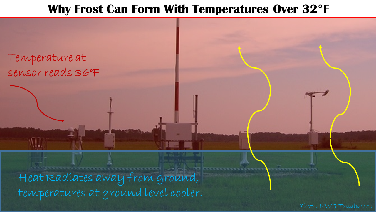
Since frost can form at or near ground level while observed air temperatures are slightly above freezing, frost advisories are issued for the 33-36° temperature range. Air temperatures are observed at a height of 2 meters (6.56 feet) above ground level. At night, heat radiates away from the ground, leaving the air very close to the ground the coldest. Therefore, when temperatures being observed by the sensor range between 32° and 36°, the temperature at ground level may be cold enough to support frost formation, given light winds and high relative humidity.
A basic graphic explaining this concept is shown below:
| Product | Criteria | Suspended |
| Frost Advisory | Issued up to 24 hours when temperature is forecast to be between 32° and 36° on nights with calm winds when surface relative humidity is expected to approach or reach 100%. | Suspended for season after the first widespread frost is observed, usually until March 15th. Frost will still be mentioned in the point-and-click forecasts when applicable. Discretionary exception: if plant blooming occurs earlier than expected from abnormal warmth. |
| Freeze Watch/Warning | Issued up to 24-48 hours in advance when temperature is 32° or lower for at least 2 hours. | Suspended after after the first widespread light freeze (26-32°) for the remainder of the cool season, usually until March 15th. Main exception: for a hard freeze of at least 25°. Will be specified in the "what" portion of the watch/warning product. |
| Cold Weather Advisory | Issued up to 24 hours for temperatures or wind chills of 10-19° for Alabama & Georgia and 15-24° or lower for Florida counties. | No suspensions. Was previously known as a Wind Chill Advisory. Graphic on bottom left. |
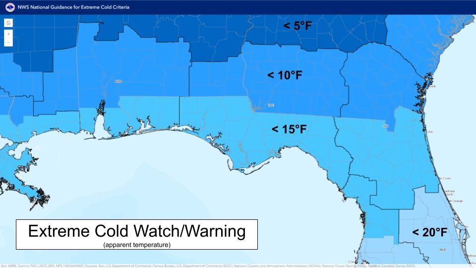
| Extreme Cold Watch/Warning | Issued up to 24-48 hours for temperatures or wind chills less than 10° for Alabama & Georgia and below 15° for Florida counties. | No suspensions. Was previously known as a Wind Chill Watch/Warning. Graphic on bottom right. |
The table below summarizes the average first frost, freeze, and hard freeze dates for all of the climate sites in our forecast area based on the current 30-year (1991-2020) climate-normal period. Most locations experience their first frost in early November, first freeze in late November, and first hard freeze in late December/early January. It is important to remember that in the wintertime, the Tallahassee Airport is often quite a bit cooler than areas within the city limits, especially during clear nights with calm winds.
| Site | First Frost | First Freeze | First Hard Freeze |
| Tallahassee (TLH) | Nov. 10 | Nov. 25 | Dec. 23 |
| Apalachicola (AAF) | Nov. 24 | Dec. 13 | Jan. 20 |
| Panama City (ECP) | Nov. 12 | Nov. 24 | Dec. 25 |
| Marianna (MAI) | Nov. 9 | Nov. 24 | Dec. 24 |
| Dothan (DHN) | Nov. 12 | Nov. 28 | Dec. 30 |
| Albany (ABY) | Nov. 7 | Nov. 18 | Dec. 23 |
| Valdosta (VLD) | Nov. 9 | Nov. 23 | Jan. 4 |

