Tropical Storm Cristobal
Tropical Storm Cristobal started as an area of circulation over the Yucatan peninsula which was the remnants of Tropical Storm Amanda that moved east over Mexico from the eastern Pacific Ocean. It reformed as a Tropical Depression over the Bay of Campeche on June 1st, before strengthening to a tropical storm and moving south to make landfall in Mexico on June 3rd, with 60 MPH sustained winds. It meandered over land as a Tropical Depression for over 48 hours before restrengthening to a Tropical Storm and moving back over the southern Gulf of Mexico on June 5. Cristobal tracked northward across the Gulf of Mexico and eventually made landfall in southeast Louisiana on Sunday, June 7, 2020 at 5 PM CDT with winds of 50 MPH and a pressure of 992 mb. Because of the size of the system, impacts were felt well to the east of the center, with heavy rain, flash flooding and storm surge flooding observed across the forecast area. A full summary of the observed hazards and impacts across the National Weather Service Tallahassee forecast office can be found in the Post-Tropical Cyclone Report.
 |
|
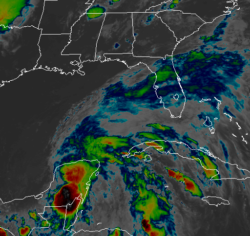
IR Satellite of Tropical Storm Cristobal |
Bands of moderate to heavy rainfall impacted the local area from Friday night through Monday morning. The highest rainfall amounts were in Madison, Taylor and Lafayette counties in Florida. Radar estimated rainfall amounts were 10 to 15 inches in that area with a gauge in Madison County reporting 12.27 inches. The rest of the central Florida panhandle and portions of southwest Georgia observed 2 to 4 inches with isolated amounts of 6-8 inches. Areas in southeast Alabama and the remainder of southwest Georgia recorded around 2 inches or less of rainfall. A link to the rainfall totals during Tropical Storm Cristobal for the NWS Tallahassee area can be found here.
 |
| Rainfall totals Saturday through Sunday afternoon. Additional amounts were recorded through Monday morning. |
The high rainfall amounts across portions of Florida and Georgia resulted in road closures with the majority of these closures in the eastern portions of Madison County. In addition, one residential structure sustained major flood damage in Madison County with five others affected by nuisance flooding.
 |
 |
| Flooding in Madison County field. Picture courtesy of Debi Tuten. |
Flooding near home in Madison County. Picture courtesy of Derrick Blue. |
On Friday, Storm Surge Watches were issued for the counties along the coast of Apalachee Bay with 2-4 feet of inundation expected. With future model runs, the forecasted inundation amounts decreased to 1 to 3 feet. The Storm Surge Watch was dropped and replaced with a Coastal Flood Advisory for the entire coastline from Walton County eastward to Taylor County.
| Location | Water Level (MHHW) |
| Panama City Beach - PCBF1 | 2.39 |
| Apalachicola - APCF1 | 2.38 |
| Spring Creek - SBIF1 | 2.19 |
| Panama City - PACF1 | 2.10 |
| Steinhatchee - STIF1 | 1.92 |
| White City- SEWF1 | 1.89 |
| Suwannee - SUWF1 | 1.84 |
| Nutall Rise- NUTF1 | 1.73 |
 |
 |
| Initial storm surge forecast with Storm Surge Watch for the Apalachee Bay coast | Future lower forecasts for surge resulted in the Storm Surge Watch cancellation and the issuance of a Coastal Flood Advisory |
 |
.JPEG) |
| Storm Surge flooding across Bottoms Road in Panacea | Beach erosion in Walton County |
Wind gusts along the coast were mainly in the 30 to 40 mph range, however a few higher gusts were observed. The highest gust was at Panama City Beach (PCBF1) with a gust of 48 MPH with the next highest gust at Gulf Coast State College with 46 MPH.
| Location | Observed Gust (MPH) |
| Panama City Beach (PCBF1) | 48 |
| Gulf Coast State College (GCSC) | 46 |
| Choctaw Beach (CHOC) | 44 |
| Bald Point (KFLALLIG2) | 44 |
| Panama City Beach (XPAN) | 43 |
| Ed Walline Beach (EDWA) | 41 |
| Tyndall AFB Tower C | 40 |
| St. Andrew Bay (XSTA) | 39 |

