Overview
A busy day of weather on Tuesday, March 31, 2020 brought widespread severe weather to the area with five tornadoes confirmed across the region. The strongest of these tornadoes was an EF-2 (when it was in Alabama) that started in Barbour county before it moved northeast into Quitman county Georgia and was rated an EF-1. Other tornadoes impacted parts of the Florida Panhandle, including one that crossed Interstate 10 in Madison county Florida and shutdown the interstate for several hours.
 |
 |
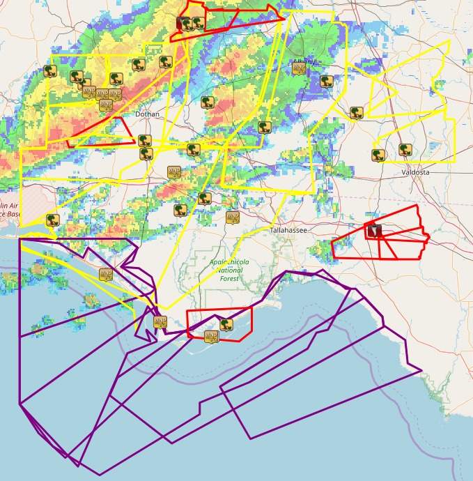
| Region wide overview of the warnings issued by the office for this event. Red boxes are tornado warnings, yellow are severe thunderstorm warnings, and purple are special marine warnings. The icons are various types of local storm reports (LSRs). | Satellite Imagery of this storm system as it proceeded through the region on Tuesday afternoon of March 31. |
Tornado Information
|
Tornado - Barbour Co. AL → Quitman/Randolph Co. GA
Track Map
This tornado originated in the NWS Birmingham area of responsibility, and then moved into ours. Some data, including path length, has been combined; other's separated. To view more information on the damage that occurred in their area, please view their webpage here. |
||||||||||||||||
|
Tornado - Jefferson/Madison County #1
Track Map   |
||||||||||||||||
|
Tornado - Madison County #2
Track Map  |
||||||||||||||||
|
Tornado - Madison County #3
Track Map 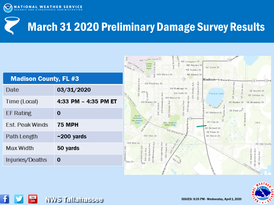 |
||||||||||||||||
|
Tornado - Walton County
Track Map  |
||||||||||||||||
The Enhanced Fujita (EF) Scale classifies tornadoes into the following categories:
| EF0 Weak 65-85 mph |
EF1 Moderate 86-110 mph |
EF2 Significant 111-135 mph |
EF3 Severe 136-165 mph |
EF4 Extreme 166-200 mph |
EF5 Catastrophic 200+ mph |
 |
|||||
Photos & Video
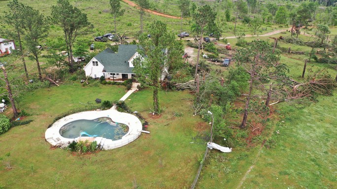
Barbour County, AL → Quitman/Randolph County, GA Tornado
 |
 |
 |
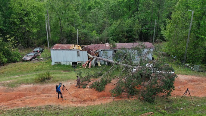 |
| Damage in Eufaula, AL just to the west of the NWS Tallahassee forecast area. This was in Birmingham's forecast region. | Aerial overview of damage that occurred just east of Eufaula, AL and the Walter F George Reservoir along Deer Point Rd | Additional tree and home damage near Deer Point Rd northeast of Georgetown, GA. | Mobile home damaged as a tornado felled a tree onto the home near US Highway 82. One injury (non-severe) occurred. |
Aerial images here were provided courtesy Brad Taylor, Quitman County EMA.
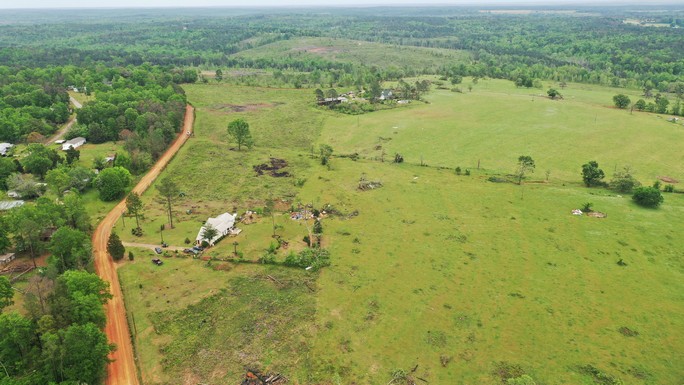
Jefferson/Madison County #1, FL
| Damage near Walker Springs Thomas City Rd and south Salt Rd at the beginning of the tornado. | Damage near Walker Springs Thomas City Rd and south Salt Rd at the beginning of the tornado. | Additional Tree Damage on Lanier Rd northeast of where the tornado originated. | Damage east of US Highway 19 near SW Overstreet Ave. |
Madison County #2, FL
| The tornado began about one mile SW of the intersection of US Highway 221 and I-10 in Madison County. | Additional damage near where the tornado begin near US Highway 221. | Damage along I-10 just east of the intersection of US Highway 221. The tornado also caused trees to fall onto the interstate, blocking traffic for some time | Tree Damage east-northeast of the Hixton Swap just southwest of the city of Madison, FL where the tornado is estimate to have lifted. |
I-10 AT STANDSTILL:Traffic is at a standstill on I-10 near Greenville exit right now as the county's emergency management team reports downed trees in the area. Two possible tornadoes reportedly ripped through the area. (📸: Russell / @warrior7892) pic.twitter.com/finzIqOR8j
— ABC 27 (@abc27) March 31, 2020
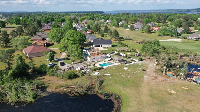
Madison County #3, FL
| Damage in southern Madison off of Duvall St. | Damage in southern Madison off of Duvall St. | Damage in southern Madison off of Bennett St. |
 |
Media use of NWS Web News Stories is encouraged! Please acknowledge the NWS as the source of any news information accessed from this site. |
|


