Overview
A spring severe weather system brought widespread severe weather to the deep south on March 30 and 31st, 2022. While there were many severe thunderstorm warnings; and a few tornado warnings across the Panhandle, Southeast Alabama, and Southwest Georgia, severe weather was not as widespread for us as it was it was for our neighbors to the west and northwest. Despite these differences, conditions lined up just right for a strong tornado (EF-3) to impact portions of Washington and Jackson counties in Florida.
Images on this site can be magnified. Click in a image to magnify it, and then click it again to return it to its normal size.
 |
|
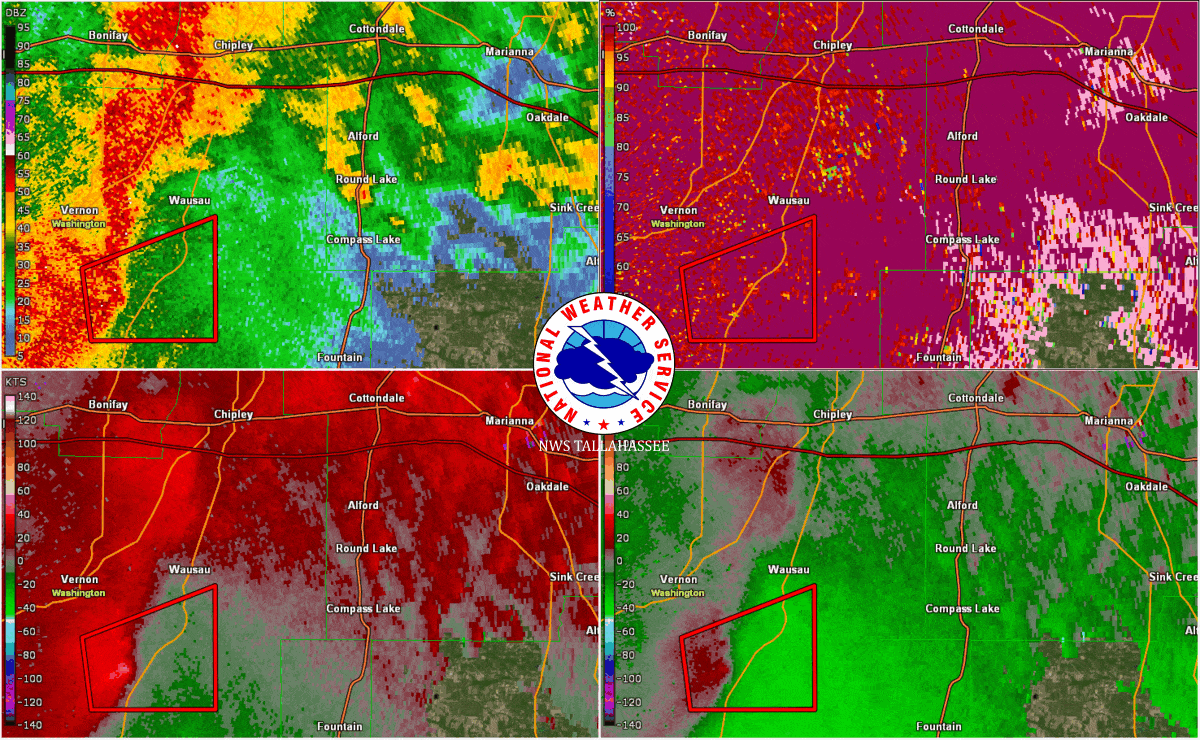
| Radar animation of the line of storms, and embedded supercell, that broad a dangerous and strong tornado into eastern portions of Washington County and western portions of Jackson County, Florida. | |
 |
|
Survey Summary:An EF-3 tornado tracked through Washington County into Jackson County Florida during the early morning hours of Thursday, March 31, 2022. The tornado began near Roland Rd and Ovid Ln in Washington County where it snapped tree trunks as it moved northeastward. The tornado crossed Orange Hill Rd and continued on to Gilberts Mill Rd. On Gilberts Mill Rd near Stewart Rd, a barn was destroyed and a manufactured home was damaged and shifted on its foundation, which is in line with EF-1 damage. Snapped and uprooted trees were observed all along Gilberts Mill Rd. Further northeast, a manufactured home sustained significant damage and several outbuildings were destroyed. A camper and a greenhouse were also destroyed here, consistent with EF-1 damage. The tornado strengthened as it continued northeastward along Gilberts Mill Rd before completely destroying and sweeping away an anchored double wide manufactured home and a newer, anchored single wide home. The double wide home was the site of the two fatalities, and one person in the single wide was injured when he was thrown into the tree line grasping his mattress. Several projectiles were driven into the ground at this location. A large boat was also thrown from its trailer and overturned. Damage at this location was consistent with strong EF-2 winds. The tornado continued to strengthen as it moved across Jewell Rd and at that location, a well-built brick home was partially destroyed and likely was sideswiped by the tornado. The end of the home that was hit sustained major collapse of roof and exterior brick walls as well as a generator ripped from its anchoring and thrown across a field. The other end of the home was less severely damaged but still suffered major roof loss. A car in the driveway was pushed off of the driveway, and an attached carport was destroyed. Across the street, a wood frame home with block foundation was completely destroyed and swept from the foundation, leaving only some cinder blocks and a floor joist. The debris from the house was thrown into a pole barn which was also destroyed. An injury occurred at this site when the home occupant ran to the barn and dove under his pickup truck. The damage to this home and the brick home are consistent with EF-3 damage and maximum winds of 150 mph. The tornado weakened some as it moved northeast, inflicting roof damage to a home and damage to out buildings along Archie Sapp Rd. On Syfrett Rd, several sheds and outbuildings were destroyed, a single wide manufactured home was flipped onto its side, and a brick home sustained major roof damage. This damage along Archie Sapp Rd and Syfrett Rd are consistent with EF-1 damage. The tornado snapped a couple of tree trunks along Dilmore Rd before lifting just south of Interstate 10 near Standland Rd. |
|
Damage near beginning of the tornado along Orange Hill Rd. Photo: NWS Survey |
Farm building completely destroyed near the beginning of the tornado along Gilberts Mill Rd. Photo: NWS Survey |
Double-wide manufactured home completely destroyed along Gilberts Mill Rd. The contents of the home were through into the tree line 100+ yards away (not pictured). Photo: NWS Survey |
The total destruction of a single wide home. The debris from this home was thrown into a nearby tree line 100+ yards away (not pictured). Photo: NWS Survey |
|
Debris of the double and single wide manufactured homes thrown into the nearby tree line (over 100 yards from where the homes stood). Photo: NWS Survey |
One example of the many projectiles from destroyed homes found in the area. Photo: NWS Survey |
Damage along Jewell Rd to a well-built brick home. The roof was completely destroyed. Photo: NWS Survey |
Home completely lifted off of foundation and thrown into nearby yard. Along Jewell Rd. Photo: NWS Survey |
|
Structure destroyed off Syfrett Rd. Photo: NWS Survey |
Metal building completely destroyed, but contents inside remained mostly undisturbed. Photo: NWS Survey |
A grain silo off Syfrett Rd uplifted and thrown into a nearby field. Photo: NWS Survey |
Damage off Dilmore Rd just south of I-10. This was near the end of the tornado's path as it would go on to lift just before/near I-10. Photo: NWS Survey |
 |
Media use of NWS Web News Stories is encouraged! Please acknowledge the NWS as the source of any news information accessed from this site. |
|

