Overview
An active weather pattern during the 2nd week of May brought several rounds of severe weather. One round in particular, on the morning of Friday, May 10, brought an intense squall line to the tri-state region. This round spawned at least 5 tornadoes, including several in Leon county and the Tallahassee area. The scale of the damage from this severe weather event and tornadoes met or exceeded damage from Hermine, Michael, and Idalia combined according to one City of Tallahassee metric (broken power poles). Numerous trees were damaged across city of Tallahassee and elsewhere across the forecast area with extensive damage occurring to the city's utility structures in and along the vicinity of the tornadoes' paths.
Images on this site can be magnified. Click in a image to magnify it, and then click it again to return it to its normal size.
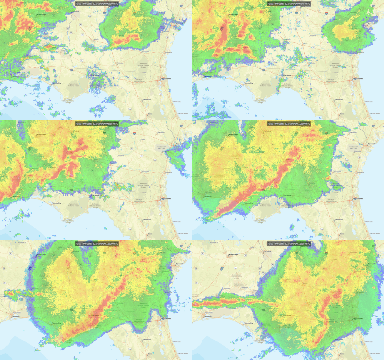 |
| Regional radar showing the progression of the complex of storms as it moved through the forecast area. In addition to several tornadoes, many areas along this line of storms suffered scattered damaging wind gusts that brought down many trees, powerlines, and cause some damage to homes. |
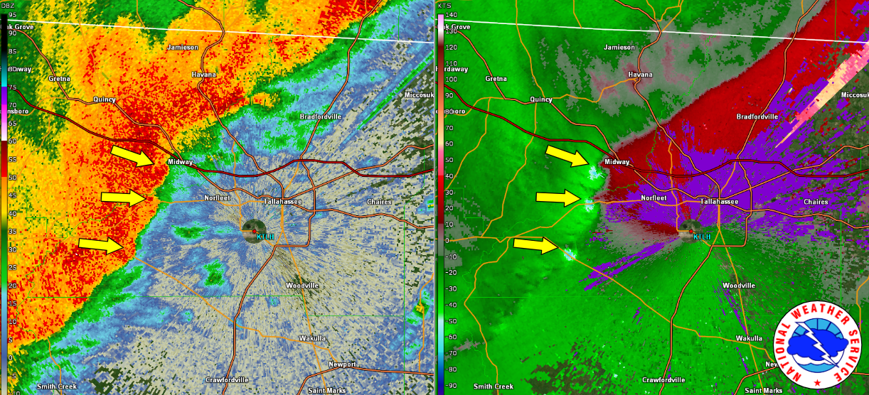 |
| Radar image at 6:49am EDT on May 10th showing the three distinct segments on the line where there were tornadoes on the ground. The two circulations just southwest of Midway, FL are the ones that what would end up merging together in Tallahassee. The third circulation ended up traveling towards Woodville, Florida in southern Leon County. The radar image on the left is reflectivity and the one on the right is called velocity. Meteorologists use the velocity data, along with other data, to determine if a tornado is occurring or is likely to occur very soon. |
Storm Information
Higher resolution track data can be found by visiting the Damage Assessment Viewer here.
| Leon/Gadsden/Tallahassee, FL Tornadoes |
 |
 |
Tornado # 1 Summary:
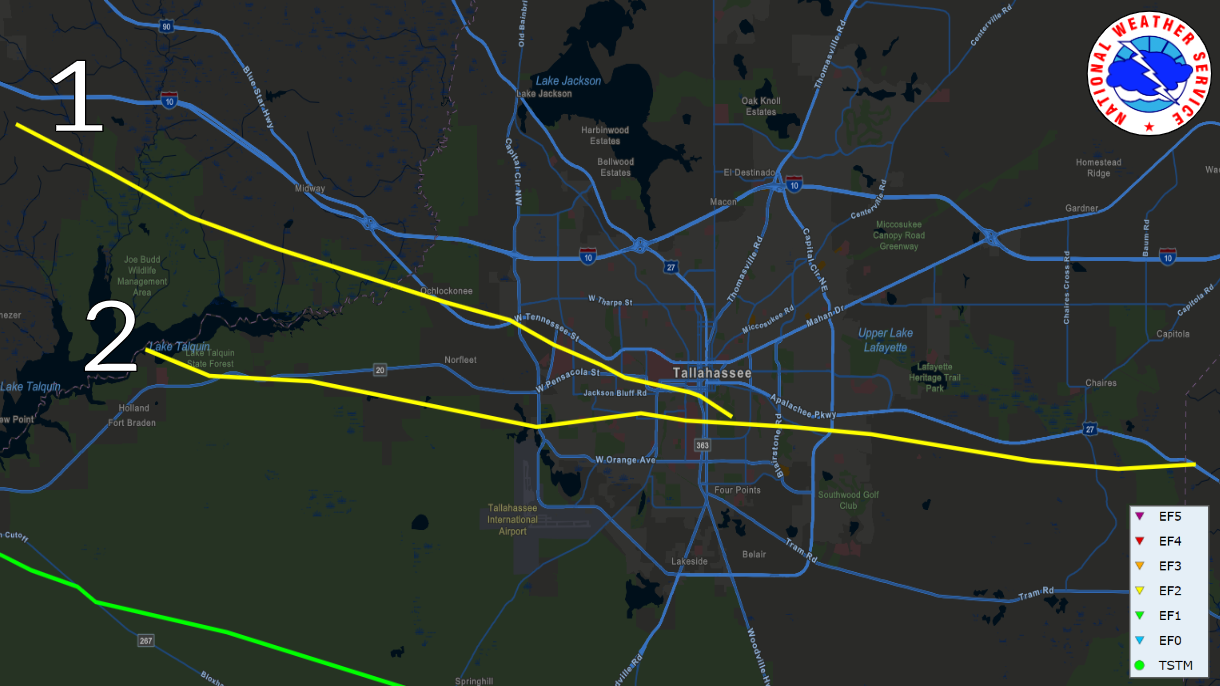
The tornado touched down at approximated 6:38AM ET near Spooner Road in eastern Gadsden County, initially damaging an old barn or farm building. The tornado track southeastward, snapping and uprooting trees through the remainder of Gadsden County before crossing the Ochlockonee River and entering western Leon County just southwest of U.S. 90. Extensive tree damage was noted at a mobile home park on Emily Loop where several homes were damaged by falling trees. The tornado caused roof and siding damage to a hotel and shopping center near the intersection of Capital Circle Northwest and U.S. 90. The tornado appears to have intensified as it moved southeast after crossing Capital Circle and approaching Blountstown Highway. EF-2 damage was noted to an automotive repair building along Blountstown Highway, along with intense tree damage, with a swath of nearly every pine tree snapped at approximately 75 feet above the ground. This level of damage continue across Pat Thomas Boulevard. Significant tree damage was noted on the campuses of Lively Technical College and Tallahassee Community College before the tornado crossed Appleyard Drive. Another area of intense tree damage was noted along Cactus Drive, consistent with an EF-2 rating. Numerous homes were damaged by falling trees. The tornado then moved through a densely populated area of single family and multi-family homes, causing widespread EF-1 tree damage. Numerous homes and businesses were damaged by falling trees as the tornado crossed Pensacola Street and approached the Florida State University Campus. Numerous trees were downed on the southwestern part of the campus. In addition, the tent housing the Florida State University Flying High Circus was destroyed and the outfield fence at Dick Howser Stadium was severely damaged. The tornado moved along Gaines Street, causing damage to a few businesses, and causing a construction crane to collapse. At Railroad Square, several warehouse buildings were severely damaged, along with the roof of the railroad depot. Snapped and uprooted trees were also noted in the downtown area, just south of the State Capital Building near the state Department of Education Building. At this point, the tornado began to turn more southeastward as it began to interact with the nearby tornado to its south. The tornado caused damage at Cascades Park, and significant tree damage in Myers Park. The tornado then moved through Country Club Estates and onto the Capital City Country Club. At this time, the track converged with that of the tornado to the south, with the tornado to the south appearing to become the dominant feature moving forward. The peak intensity EF-2 intensity of 115mph is estimated to have occurred in a couple of spots between Blountstown Highway and Cactus Street. The maximum width was approximately 900 yards.
| Tornado # 1 |
| Date |
May 10, 2024 |
| Time |
6:38 am - 7:03 am EDT |
| EF Rating (Max) |
2 |
| Est. Peak Winds |
115 mph |
| Path Length |
19.58 miles |
| Max Width |
900 yards |
| Injuries/Deaths |
- |
|
Tornado # 2 Summary:
The tornado touched down at approximately 6:50AM ET in Lake Talquin State Park at Williams Landing, promptly producing EF-1 damage snapping numerous softwood and hardwood trees. The tornado would then continue trekking east-southeast before making a hard right and traveling due east as it passed the intersection of Blountstown Highway and Ft. Braden Trail Road, producing damage consistent with an EF-1 rating by snapping numerous hardwood and softwood trees along the way. The tornado would then continue east, paralleling Blountstown Highway as it then impacted Lake Talquin State Recreational Area where it would continue producing EF-1 damage by snapping trees. The tornado would then shift its trajectory to east-southeast once again, impacting many subdivisions in the Norfleet neighborhood south of Blountstown Highway snapping numerous trees across the area. It would then continue on its east-southeast path before traveling east once again as it reached just north of the intersection of Capital Circle SW and Orange Ave W in Tallahassee. It would then go on to impact the neighborhoods of Seminole Manor and Mabry Manor snapping many trees along the way and causing damage to Sabal Palm Elementary School. The tornado would then continue its eastern track impacting Florida A&M University (FAMU) producing EF-1 damage by snapping numerous trees along the way. This included roof damage to at least two university buildings. EF-0 damage was observed a handful of times to eve's on homes and businesses as well as occasional shingle damage. The tornado would continue moving east toward Capital City Country Club Golf Course producing EF-1 damage by snapping numerous trees along the way and across the golf course. The tracks of both tornadoes moving through Tallahassee at this time coverged at Capital City Country Club, with this tornado seemingly becoming the dominant circulation moving forward. As the tornado exited the golf course, very intense tree damage consistent with an EF-2 rating was observed as numerous trees were snapped at a height of around 75 feet. This most intense tree damage occurred from Country Club Dr. through the Indian Head Acres subdivisions. This is where the maximum estimated winds of 115mph most likely occurred. EF-1 damage would be observed through the remainder of its eastern trajectory as the tornado impacted Old St. Augustine Rd. It would go on producing EF-1 tree damage within the subdivision of Paradise Village East, Old Friends Rd, and areas along Southwood Plantation Rd before moving on to mostly forested areas north of Old St. Augustine Rd. The last concentrated area of EF-1 damage would be observed in neighborhoods along Louvinia Drive and WW Kelley Road. The tornado would then continue east before uprooting a few trees along U.S. 27 as it crossed into Jefferson county, FL before dissipating around 7:14AM ET. The tornado reached its maximum width of 1400yds as it crossed Monroe St. in downtown Tallahassee and entered into the Capital City Country Club Golf Course.
| Tornado # 2 |
| Date |
May 10, 2024 |
| Time |
6:50 am - 7:14 am EDT |
| EF Rating (Max) |
2 |
| Est. Peak Winds |
115 mph |
| Path Length |
27.22 miles |
| Max Width |
1,400 yards |
| Injuries/Deaths |
- |
|
Tornado #3 Summary:
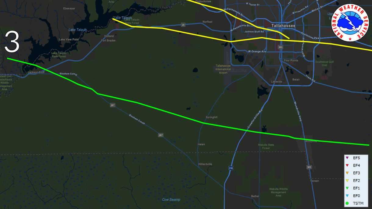
The tornado touched down near Lake Talquin Hwy, just west of Lake Talquin, at approximately 6:50AM ET, promptly producing EF-0 tree damage. It then crossed Lake Talquin a few minutes later before moving ashore on the eastern shore of Lake Talquin where it produced EF-1 damage with several snapped and uprooted trees, some of which fell on two cars and a couple of houses. The tornado would then continue heading generally east-southeast with EF-1 damage across Blountstown Hwy and along and just south of Bloxham Cutoff Road before heading more east across Apalachicola National Forest, where downed and snapped trees were noted along some of the National Forest Roads. The tornado then crossed Springhill Road near the Trout Pond GF&A Trailhead, producing high-end EF-1 damage as it did so. The tornado then continued generally east-southeast towards US-319 near Oak Ridge Road W, continuing to produce high-end EF-1 damage. The tornado continued along Oak Ridge Road, producing EF-1 damage with several downed and snapped trees noted along the road. Another cluster of high-end EF-1 damage was noted on the west side of Woodville Hwy near Oak Ridge Road E. The tornado passed just north of Woodville Middle School, with numerous downed and snapped trees noted between Oak Ridge Rd E and Natural Bridge Road. The tornado crossed over Taff Road, where it continued to produce high-end EF-1 damage before moving over forest and farmland that was inaccessible to the survey team. Another cluster of snapped trees were noted along Old Plank Road, where the tornado was likely ongoing before lifting just east of Old Plank Road at approximately 7:13AM EDT. The maximum width was around 1100 yards along Celia Road, west of Woodville.
| Tornado # 3 |
| Date |
May 10, 2024 |
| Time |
6:42 am - 7:13 am EDT |
| EF Rating (Max) |
1 |
| Est. Peak Winds |
110 mph |
| Path Length |
31.69 miles |
| Max Width |
1,100 yards |
| Injuries/Deaths |
- |
|
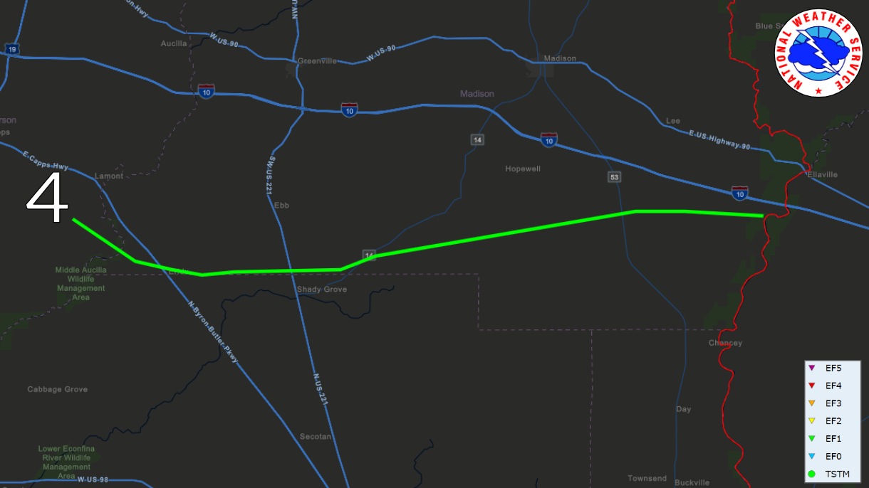
| Madison/Jefferson/Taylor County, FL and Houston County, AL Tornadoes |
 |
 |
Tornado #4 Summary:
The tornado initially touched down in Jefferson county at 7:31 AM ET just north of the intersection of Hall Rd. and S. Salt Rd. where it twisted, uprooted, and snapped many young pine trees on the side of the road as it moved southeast. The tornado would first reach EF-1 intensity as it crossed SW Mount Olive Church Rd. in Madison County where numerous trees were uprooted and a trailer was damaged. The tornado would then begin a more easterly trajectory following a brief dip into Taylor county where trees were snapped in multiple spots along SW Raymond Sheffield Dr. before moving back into Madison county. It would continue east-northeast through Madison county mostly through rural areas producing concentrated areas of EF-1 damage to pine and oak trees throughout the duration. The tornado would continue its path over farmland just south of state route 8, tipping and twisting many irrigation spickets as well as snapping and uprooting adjacent trees. The tornado would dissipate at 8:02 AM over a field just west of the Madison-Suwannee county border. This tornado would reach EF-1 status with maximum winds of 100mph and a maximum width of 1300yds..
| Tornado # 4 |
| Date |
May 10, 2024 |
| Time |
7:31 am - 8:02 am EDT |
| EF Rating (Max) |
1 |
| Est. Peak Winds |
100 mph |
| Path Length |
38.19 miles |
| Max Width |
1,100 yards |
| Injuries/Deaths |
- |
|
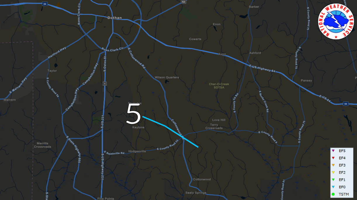
Tornado #5 Summary:
A tornado touched down along Hooper Cherry Road early on the morning of May 10th. Initial damage was to trees. Additional damage occurred along A.J. Register Road, where significant damage to outbuildings was noted. The tornado continued southeastward, crossing Cottonwood Road near County Road 33. Roof damage to farm buildings was observer here. Additional tree and roof damage was noted along Gene Terry Road south of Nobles Road. The tornado dissipated shortly after this point. The damage was consisted with an EF-0 rating and maximum winds of approximately 85mph.
| Tornado # 5 |
| Date |
May 10, 2024 |
| Time |
4:02 am - 4:20 am CDT |
| EF Rating (Max) |
0 |
| Est. Peak Winds |
85 mph |
| Path Length |
4.45 miles |
| Max Width |
125 yards |
| Injuries/Deaths |
- |
|
| Walton County, FL Tornado |
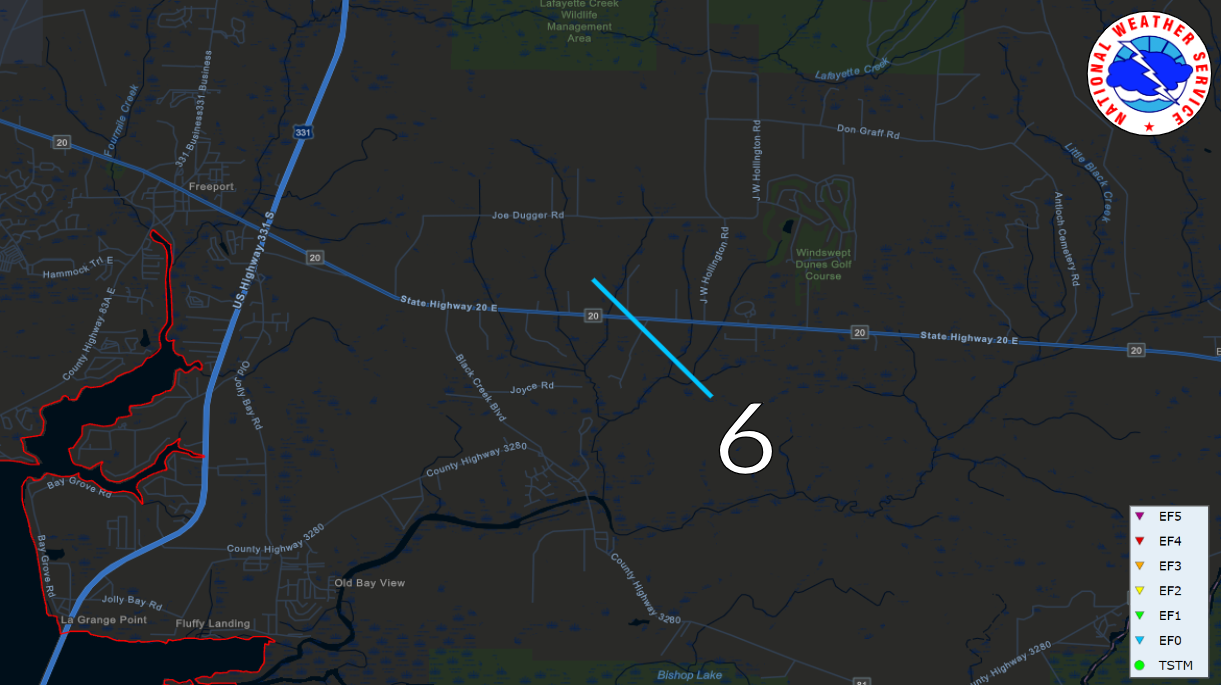 |
Tornado #6 Summary:
A brief EF0 tornado moved across Highway 20 west of J W Hollington Road with damage to trees along Highway 20. A brief TDS was present on EVX radar.
| Tornado # 6 |
| Date |
May 10, 2024 |
| Time |
4:47 am - 4:49 am CDT |
| EF Rating (Max) |
0 |
| Est. Peak Winds |
80 mph |
| Path Length |
1.69 miles |
| Max Width |
25 yards |
| Injuries/Deaths |
- |
|


