A public information statement outlining the details of this tornado is available below the following image.
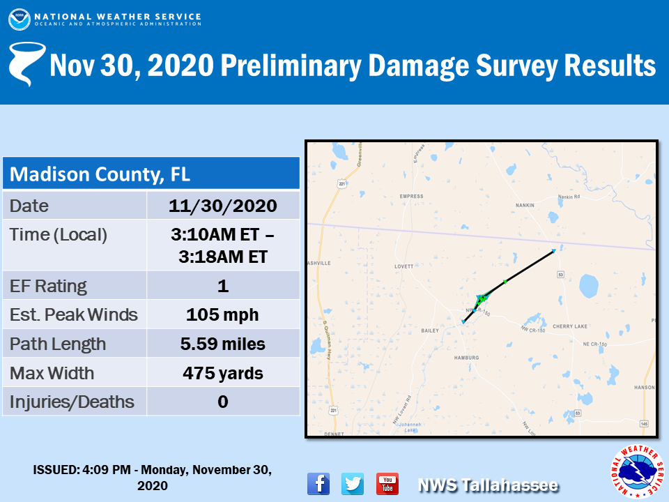
Public Information Statement
National Weather Service Tallahassee FL
302 PM EST Mon Nov 30 2020 /202 PM CST Mon Nov 30 2020/


...NWS DAMAGE SURVEY FOR 11/30/2020 TORNADO EVENT...

.Madison County Tornado...

Rating:                 EF1
Estimated Peak Wind:    105 mph
Path Length /statute/:  5.5974 miles
Path Width /maximum/:   475.0 yards
Fatalities:             0
Injuries:               0

Start Date:             11/30/2020
Start Time:             03:10 AM EST
Start Location:         1 NNW Hamburg / Madison County / FL
Start Lat/Lon:          30.5923 / -83.5222

End Date:               11/30/2020
End Time:               03:18 AM EST
End Location:           2 SE Nankin / Madison County / FL
End Lat/Lon:            30.6365 / -83.4448

Survey Summary:
Tornado initially touched down near NW Little Cat Road in Madison
County. Significant tree damage and minor structural damage was
noted at a home along County Road 150. The tree damage
intensified as the tornado moved northeast across a quail farm
along Boggy Bay Road. Significant tree damage and damage to farm
outbuildings suggests EF-1 intensity. This was the tornado`s
widest point. The path narrowed as it crossed County Road
253 where a significant number of snapped pine trees was noted.
The tornado then weakened, with no other known structural damage,
before lifting just southwest of State Road 53 near the Florida-
Georgia line. Maximum winds are estimated to be 105 mph with a
maximum width of 475 yards. Thanks to Madison County Emergency
Management and Florida Division of Emergency Management for help
with the survey.

EF Scale: The Enhanced Fujita Scale classifies tornadoes into the
following categories:

EF0...Weak......65 to 85 mph
EF1...Weak......86 to 110 mph
EF2...Strong....111 to 135 mph
EF3...Strong....136 to 165 mph
EF4...Violent...166 to 200 mph
EF5...Violent...>200 mph

NOTE:
The information in this statement is preliminary and subject to
change pending final review of the event and publication in NWS
Storm Data.

