Tornadoes and Damaging Wind Hit
Southeast Alabama and Southwest Georgia
January 2, 2017
A strong line of showers and thunderstorms moved through southeast Alabama, southwest Georgia and north Florida on Monday, January 2, 2017. More than 30 warnings were issued across the tri-state area as these powerful storms moved through. Ten tornadoes were confirmed across southeast Alabama and southwest Georgia with additional wind damage noted in Geneva County, AL and Dougherty and Turner Counties in Georgia.
 |
 |
Calhoun County Tornado
Rating:                 EF0
Estimated Peak Wind:    85 mph
Path Length /statute/:  0.66 miles
Path Width /maximum/:   400 yards
Fatalities:             0
Injuries:               0

Start Date:             01/02/2017
Start Time:             09:52 PM EST
Start Location:         Calhoun County / GA
Start Lat/Lon:          31.4846 / -84.5174

End Date:               01/02/2017
End Time:               09:54 PM EST
End Location:           Calhoun County / GA
End Lat/Lon:            31.4928 / -84.5117
Survey Summary:
An EF-0 tornado touched down along Mercer Avenue and lifted near Bray Street. Damage consisted of numerous uprooted trees and minor damage to many roofs and outbuildings.
Miller-Baker Tornado
Rating:                 EF1
Estimated Peak Wind:    105 mph
Path Length /statute/:  9.97 miles
Path Width /maximum/:   1000 yards
Fatalities:             0
Injuries:               0

Start Date:             01/02/2017
Start Time:             09:41 PM EST
Start Location:         2 SSW Cooktown / Miller County / GA
Start Lat/Lon:          31.1844 / -84.5714

End Date:               01/02/2017
End Time:               09:53 PM EST
End Location:           1 NNE Hawkinstown / Baker County / GA
End Lat/Lon:            31.2745 / -84.4412
Survey Summary:
EF-1 tornado touched down near Albany Highway and Kimbrel Road in eastern Miller County. The tornado traveled northeast, doing heavy damage to trees in along the path. A home and outbuildings were damaged near Highway 200 in Baker County before the tornado lifted.
 |
 |
| Multiple trees uprooted and snapped | Fallen roof in Baker County |
Albany-Dougherty Thunderstorm Wind Event
Peak Wind /E/:          85 mph
Path Length /statute/:  9.4 miles
Path Width /maximum/:   4 miles
Fatalities:             0
Injuries:               0

Start Date:             01/02/2017
Start Time:             10:14 pm EST
Start Location:         5 W Albany / Dougherty County / GA
Start Lat/Lon:          31.571 / -84.258

End Date:               01/02/2017
End Time:               10:30 pm EST
End Location:           4 ENE Albany / Dougherty County / GA
End Lat/Lon:            31.595 / -84.105
Survey Summary:
A severe thunderstorm produced a 3 to 4 mile swath of 80 to 85 mph winds across the northern half of Albany proper, causing widespread damage across the city. The NWS damage survey team found hundreds of snapped and/or uprooted trees, minor to moderate roof damage to structures and buildings, and occasional instances of extensive damage to wide-span metal roofs in areas throughout the city. Much of the severe structural damage surveyed was a result of trees falling onto structures and powerlines, especially in the Rawson Circle area, where the roads are canopied by old oak trees. The downed trees across the city were oriented in the same direction. This, along with examination of radar data from the event suggests that the damage was caused by straight line winds.
 |
 |
| One of the numerous trees that fell on houses in the Albany area |
Numerous trees down in the Albany area |
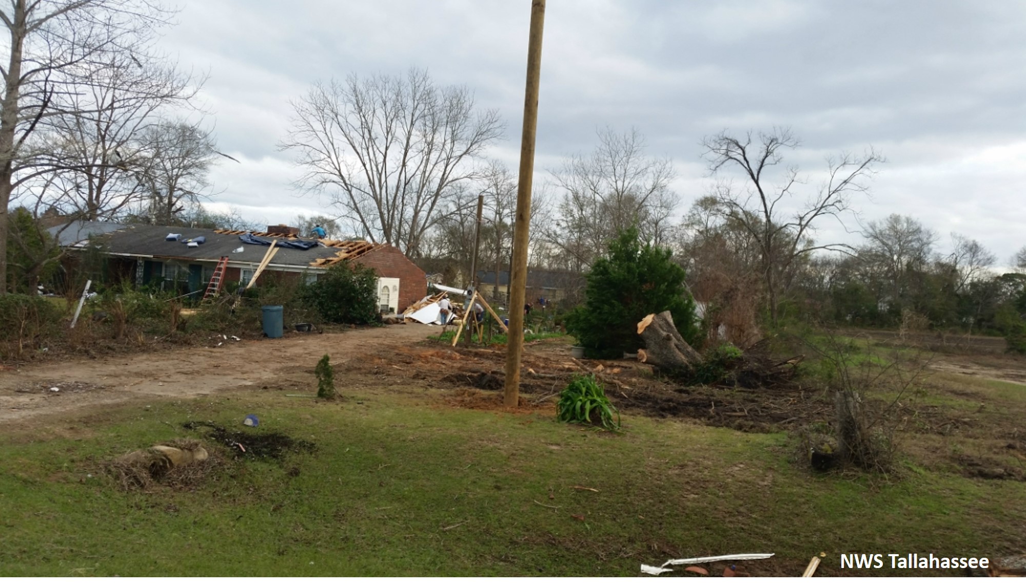
Dougherty-Worth County Tornado
Rating:                 EF1
Estimated Peak Wind:    105 mph
Path Length /statute/:  9.16 miles
Path Width /maximum/:   600 yards
Fatalities:             0
Injuries:               0

Start Date:             01/02/2017
Start Time:             10:32 PM EST
Start Location:         5 E Stocks / Dougherty County / GA
Start Lat/Lon:          31.6417 / -84.0093

End Date:               01/02/2017
End Time:               10:42 PM EST
End Location:           2 SE Doles / Worth County / GA
End Lat/Lon:            31.6783 / -83.8633
Survey Summary:
EF-1 Tornado touched down just inside the Dougherty County line along Cordele Road before moving east northeast into Worth County. The tornado lifted just east of Highway 313. A strongly convergent signature was noted in the tree damage which supports the designation as a tornado.
 |
 |
| Damage to a house in Dougherty County near the beginning of the tornado |
Numerous trees down on Dollard Road |
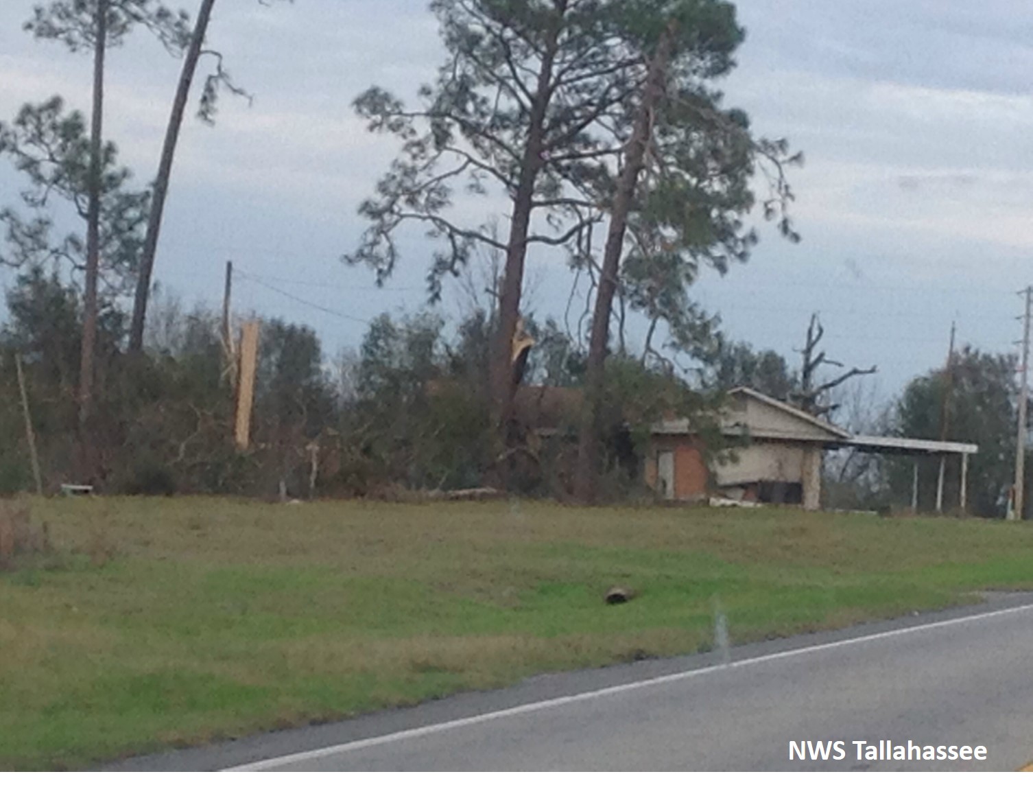
Early County Tornado #1
Rating:                 EF2
Estimated Peak Wind:    115 mph
Path Length /statute/:  4.45 miles
Path Width /maximum/:   400 yards
Fatalities:             0
Injuries:               0

Start Date:             01/02/2017
Start Time:             09:12 PM EST
Start Location:         1 E Sawhatchee / Early County / GA
Start Lat/Lon:          31.2767 / -85.0086

End Date:               01/02/2017
End Time:               09:19 PM EST
End Location:           3 WNW Centerville / Early County / GA
End Lat/Lon:            31.3053 / -84.9432
Survey Summary:
The tornado touched down on Damascus Hilton Road just east of Zion Road and moved NE toward Cedar Springs Road. At the intersection of Cedar Springs Road and Hightower Road, two residences were significantly damaged, with a portion of the roof deck removed. Additionally several farm buildings were damaged or destroyed in the area. The tornado then turned more to the east and eventually lifted when reaching Old Lucile Road. Damage further east on Rock Bluff Road near the intersection of Highway 39 was consistent with straight line wind damage with winds near 80 to 90 mph.
 |
 |
| Barn destroyed by tornado | Roof damage to a house in Early County |
Early County Tornado #2
Rating:                 EF2
Estimated Peak Wind:    115 mph
Path Length /statute/:  11.1 miles
Path Width /maximum/:   1000 yards
Fatalities:             0
Injuries:               0

Start Date:             01/02/2017
Start Time:             09:18 PM EST
Start Location:         1 SSW Centerville / Early County / GA
Start Lat/Lon:          31.2567 / -84.9037

End Date:               01/02/2017
End Time:               09:33 PM EST
End Location:           1 NNW Old Damascus / Early County / GA
End Lat/Lon:            31.328 / -84.7396
Survey Summary:
The tornado initially touched down on the Early County side of the Early-Miller County line near Three Notch Road. Damage in this area was mainly limited to trees and a few farm buildings that were destroyed. Damage in this area was generally consistent with EF1 damage. The tornado moved NE toward US-27 near the intersection with Bates Road. A mobile home suffered roof damage and numerous pines were snapped or uprooted on the west side of US-27. The tornado continued northeast and intensified before reaching Middleton Road. Many trees were snapped, with a few debarked in this area. One farm building was completely destroyed in this area. The tornado continued moving to the east-northeast and ultimately lifted near Old Damascus Road where a few trees were snapped and a pivot irrigation system was overturned.
 |
 |
| Silos destroyed by tornado | Trees snapped in Early County |
Early County Tornado #3
Rating:                 EF2
Estimated Peak Wind:    120 mph
Path Length /statute/:  4.57 miles
Path Width /maximum/:   500 yards
Fatalities:             0
Injuries:               0

Start Date:             01/02/2017
Start Time:             09:34 PM EST
Start Location:         1 SSW Rowena / Early County / GA
Start Lat/Lon:          31.369 / -84.7196

End Date:               01/02/2017
End Time:               09:41 PM EST
End Location:           1 NE Nicholasville / Early County / GA
End Lat/Lon:            31.4099 / -84.6618
Survey Summary:
EF-2 tornado touched down just west of Highway 45 north of Billy Newberry Road. The tornado lifted just north of Newton Road. There was significant tree damage along with some structural damage along the periphery of the path.
 |
 |
| Barn collapsed in Early County | Trees snapped in Early County |
Donalsonville Tornado
Rating:                 EF1
Estimated Peak Wind:    90 mph
Path Length /statute/:  3.74 miles
Path Width /maximum/:   600 yards
Fatalities:             0
Injuries:               0

Start Date:             01/02/2017
Start Time:             09:14 PM EST
Start Location:         1 N Riverturn / Seminole County / GA
Start Lat/Lon:          30.9973 / -84.945

End Date:               01/02/2017
End Time:               09:18 PM EST
End Location:           1 WSW Davis Park / Seminole County / GA
End Lat/Lon:            31.0257 / -84.8915
Survey Summary:
EF-1 tornado touched down on Grant Graham road causing damage to pecan groves, two mobile homes, and one single family home. The tornado tracked northeast for approximately 3.75 miles along Highway 91 before lifting just south of Donalsonville.
 |
 |
| Mobile home destroyed | Trees snapped in Seminole County |
Houston County McCallister Road Tornado
Rating:                 EF1
Estimated Peak Wind:    100 mph
Path Length /statute/:  2.58 miles
Path Width /maximum/:   200 yards
Fatalities:             0
Injuries:               0

Start Date:             01/02/2017
Start Time:             07:46 PM CST
Start Location:         1 WNW Ardilla / Houston County / AL
Start Lat/Lon:          31.1818 / -85.37

End Date:               01/02/2017
End Time:               07:51 PM CST
End Location:           2 SW Cowarts / Houston County / AL
End Lat/Lon:            31.184 / -85.3274
Survey Summary:
Tornado touched down along E. Cottonwood Road SE of Dothan, AL. The tornado traveled east for approx. 2.5 miles along McCallister Road before lifting near Rosewood Dr. One home had its roof removed. Others had significant shingle damage which supported the EF-1 rating.
 |
 |
| Damage to roof in Houston County | Roof lifted up by tornado |
Geneva-Houston County Tornado
Rating:                 EF2
Estimated Peak Wind:    115 mph
Path Length /statute/:  7.59 miles
Path Width /maximum/:   500 yards
Fatalities:             0
Injuries:               0

Start Date:             01/02/2017
Start Time:             07:35 PM CST
Start Location:         2 SSE Malvern / Geneva County / AL
Start Lat/Lon:          31.1104 / -85.5078

End Date:               01/02/2017
End Time:               07:44 PM CST
End Location:           1 NW Memphis / Houston County / AL
End Lat/Lon:            31.1449 / -85.3863
Survey Summary:
Tornado touched down in Geneva County near the Houston County border along Rehobeth Road before lifting after crossing US 231 just east of the National Peanut Festival Grounds. In Geneva County, the tornado debarked and denuded several large trees and removed the roof from a home under construction. In addition, numerous trees were snapped or uprooted. In Houston County, the most significant damage occurred at the National Peanut Festival grounds. Multiple buildings were damaged or destroyed and several utility poles were snapped.
 |
 |
| Outbuilding damaged at the National Peanut Festival Grounds |
Roof pulled off structure at the National Peanut Festival Grounds |
Mitchell County Tornado
Rating:                 EF1
Estimated Peak Wind:    95 mph
Path Length /statute/:  3.99 miles
Path Width /maximum/:   200 yards
Fatalities:             0
Injuries:               0

Start Date:             01/02/2017
Start Time:             10:08 PM EST
Start Location:         2 N Baconton / Mitchell County / GA
Start Lat/Lon:          31.4107 / -84.164

End Date:               01/02/2017
End Time:               10:16 PM EST
End Location:           3 SSE Putney / Mitchell County / GA
End Lat/Lon:            31.4337 / -84.1023
Survey Summary:
EF-1 tornado touched down near Flint River just west of US 19 and north of Baconton in Mitchell County. Numerous pecan trees were uprooted and pine trees snapped. There was roof damage to several mobile homes off Stage Coach Road. Tornado may have touched down a bit further west and lifted a bit further east. However, these areas were inaccessible to the survey team.
 |
 |
| Damage to a roof in Mitchell County | Numerous trees down off of Stage Coach Road |
Rehobeth Thunderstorm Wind Event
Peak Wind /E/:          85 mph
Path Length /statute/:  8.6 miles
Path Width /maximum/:   1300 yards
Fatalities:             4
Injuries:               0

Start Date:             01/02/2017
Start Time:             7:35 pm CST
Start Location:         5 SSW Taylor / Geneva County / AL
Start Lat/Lon:          31.1067 / -85.5030

End Date:               01/02/2017
End Time:               7:46 pm CST
End Location:           5 SE Dothan / Houston County / AL
End Lat/Lon:            31.1514 / -85.3671
Survey Summary:
NWS Survey Team determined that some damage in the Rehobeth area was caused by strong straight line winds on the southern flank of a tornado just to the north. Damage consisted of numerous large trees snapped or uprooted. One mobile home was split by a large tree, resulting in four fatalities. The damage pattern along this path was not convergent and was noticeably south of the path of the tornado vortex.
 |
 |
| Barn damaged by strong winds | Strong winds snapped a tree which fell on a structure in Houston County |
Turner County Thunderstorm Wind Event
Peak Wind /E/:          80 mph
Path Length /statute/:  6.5 miles
Path Width /maximum/:   8000 yards
Fatalities:             1
Injuries:               0

Start Date:             01/02/2017
Start Time:             10:49 pm EST
Start Location:         6 WNW Ashburn / Turner County / GA
Start Lat/Lon:          31.734 / -83.7417

End Date:               01/02/2017
End Time:               10:56 pm EST
End Location:           5 N Ashburn / Turner County / GA
End Lat/Lon:            31.7877 / -83.6514
Survey Summary:
NWS Survey Team determined that straight line winds of 80 mph moved across Turner County. The severe winds downed hundreds of trees, knocked over a church steeple, and removed shingles and metal roofing from mobile homes and well-constructed outbuildings. In addition, a few mobile homes were damaged by falling trees and one outbuilding was destroyed when the wind shifted it off the blocks on which it was located. This resulted in one fatality. The damage was confined to roughly a 6.5 mile by 4 mile box.
 |
 |
| Steeple blown off church | Trees snapped in Turner County |

