Miami - South Florida
Weather Forecast Office
MIAMI OBSERVATION HISTORY
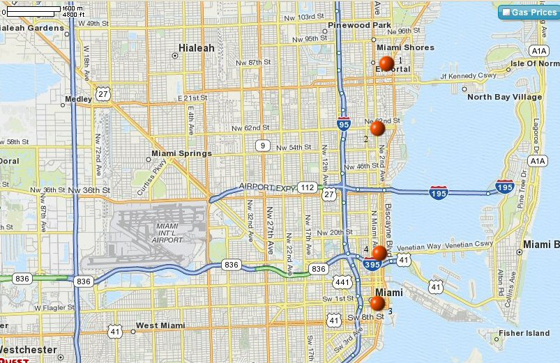
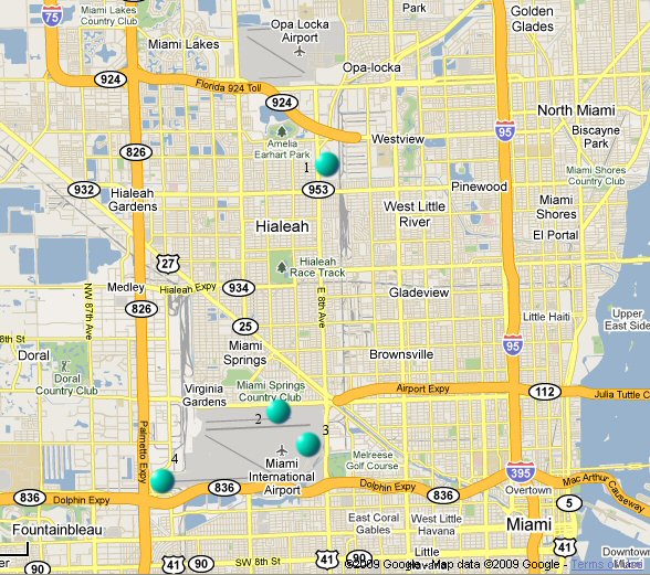
The three maps below provide chronological positions of the observation site for the period of record (including Fort Dallas, the Biscayne cooperative observation site, and the Miami sites, 1837 through the present).
MAP 1

1 - Estimated site of Biscayne (Hunt, Sturtevant, observers) 1870-1880
2 - Approximate site of Lemon City (White, observer) 1895-1900
3 - downtown sites 1-4 (see Map 2)
4 - Lindsey Hopkins Bldg, fifth site of WBO Miami, 1410 NE 2nd Ave, site of WBO Miami 1948-1958
MAP 2

Gold circle - approximate location of Fitzpatrick plantation (1830s) and Fort Dallas on the banks of the Miami River, 1837-1858, which became Julia Tuttle's homestead in 1891.
1 - Miami cooperative observation site, the Rev. Blackman observer, 1900-1911
2 - Bank of Bay Biscayne, corner of Flagler and Miami Ave., first site of WBO Miami, 1911-1914
3 - Old Federal Building, corner of 1st Ave and 1st St NE, second site of WBO Miami, 1914-1929
4 - Seybold Building, third site of WBO Miami, 1929-1943
5 - Congress Building, fourth site of WBO Miami, 1943-1948 (after 1948, all observations moved to the airport)
MAP 3

1 - first site of WBAS Miami (11229 NW 42nd Ave), old Miami Municipal Airport, 1929-1942
2 - second site of WBAS Miami (5010 NW 36th St), Pan American Field, which became Miami International Airport, 1942-1957
3 - third site of WBAS Miami (20th Street side of the airport), 1957-1975, instruments remained until 1977
4 - weather instrument location at MIA, 1977-present (ASOS commissioned May 21, 1996)
CURRENT HAZARDS
Submit a Storm Report
Outlooks
Graphical Hazardous Weather Outlook
Self Briefing Page
National Hazards
Tropics / Hurricanes
Local Storm Reports
CURRENT WEATHER
Surface Observations
Satellite
Observed Precipitation
MesoAnalysis
Rivers / Lakes
Latest Sounding
Lake Okeechobee
PAST WEATHER
Past Events
Recent Rainfall
Tropical Cyclone Reports
FORECASTS
Forecast Discussion
Tropical Weather
Probabilistic Page
Heat Page
Cold Weather Page
Marine Weather
Fire Weather
Beach Forecast
Aviation Weather
Probabilistic QPF
Hourly Forecasts
Activity Planner
Graphical Forecast
International Weather
RADAR IMAGERY
National
Miami Radar
Key West Radar
Across Florida
CLIMATE
Local Climate Info
More Local Climate Info
Climate Graphs
US Dept of Commerce
National Oceanic and Atmospheric Administration
National Weather Service
Miami - South Florida
11691 SW 17th Street
Miami, FL 33165
305-229-4522
Comments? Questions? Please Contact Us.

