Miami - South Florida
Weather Forecast Office
|
|||||
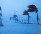
| On August 12, Hurricane Charley, after moving through the northwest Caribbean Sea, turned north and accelerated cross the western end of Cuba, and just west of the lower Florida Keys. Early on August 13, the hurricane intensified to Category 4 status and turned to a north northeast direction before making landfall near Port Charlotte around 3 PM EDT. The first outer rainband, with wind gusts estimated up to 60 mph, impacted the south Florida Peninsula between midnight and 2 AM EDT In Collier County, a peak wind gust of 84 mph was measured at 2:50 PM EDT on the top of a condominium at Vanderbilt Beach before the equipment failed. The Naples ASOS equipment failed well before the maximum winds or minimum pressure occurred. Wind gusts at La Belle were estimated at 80 mph. Rainfall in most locations in Collier County was around two inches with an unofficial amount of 7.5 inches reported in North Naples. Radar rainfall estimates of locally 8 to 10 inches were made in North Naples. Flooding was mostly minimal. The highest Storm Tide along the southwest Florida Coast was estimated at three feet near Wiggins Pass with heights of one to two feet from Naples to Marco Island to Everglades City. Tidal flooding was minimal. Lake Okeechobee levels increased up to three feet above normal along the north and northeast shores. A long-track tornado moved through the open country of the Everglades in eastern Hendry County before doing minor damage to buildings in Clewiston. Hurricane wind damage was greatest in North Naples and Vanderbilt Beach with numerous power poles, trees and signs blown down, and a few roofs damaged. Damage also occurred to screened porches throughout the Naples-Marco Island metropolitan areas. Damage occurred to Gulf-side structures along most of the coastline but beach erosion was mostly minor. Four persons in Naples suffered minor injuries when their vehicle was touched by a downed power line during the storm. Three persons in Collier County died from indirect causes after the hurricane. An estimated 130,000 customers in Collier County lost power. About 2,500 people took refuge in six shelters. Damage in Hendry and Glades counties consisted mainly of downed trees, power lines and signs, with minor roof damage to several homes. An estimated 1000 customers lost electricity in Glades County. |
|||||
Additional Information National Hurricane Center report on Hurricane Charley National Hurricane Center report on Hurricane Charley |
|||||
CURRENT HAZARDS
Submit a Storm Report
Outlooks
Graphical Hazardous Weather Outlook
Self Briefing Page
National Hazards
Tropics / Hurricanes
Local Storm Reports
CURRENT WEATHER
Surface Observations
Satellite
Observed Precipitation
MesoAnalysis
Rivers / Lakes
Latest Sounding
Lake Okeechobee
PAST WEATHER
Past Events
Recent Rainfall
Tropical Cyclone Reports
FORECASTS
Forecast Discussion
Tropical Weather
Probabilistic Page
Heat Page
Cold Weather Page
Marine Weather
Fire Weather
Beach Forecast
Aviation Weather
Probabilistic QPF
Hourly Forecasts
Activity Planner
Graphical Forecast
International Weather
RADAR IMAGERY
National
Miami Radar
Key West Radar
Across Florida
CLIMATE
Local Climate Info
More Local Climate Info
Climate Graphs
US Dept of Commerce
National Oceanic and Atmospheric Administration
National Weather Service
Miami - South Florida
11691 SW 17th Street
Miami, FL 33165
305-229-4522
Comments? Questions? Please Contact Us.