A powerful storm is expected to bring periods of heavy rain, gusty winds, and the potential for severe thunderstorms throughout the southern to central Plains through Monday. Widespread precipitation and heavy mountain snow is expected across the Northwest and northern Rockies through Monday. Up to a foot of snow is possible across the higher elevations of the Cascades and northern Rockies. Read More >
|
|||||
|
30th Anniversary Commemoration August 24th, 2022 Videos Produced by WFO Miami Senior Forecaster Tony Reynes to commemorate the 30th anniversary of Hurricane Andrew: Part 1 | Part 2 | Part 3 | Part 4 | Part 5 Florida International University Video: FIU Remembers Hurricane Andrew Summary: Hurricane Andrew was the strongest and most devastating hurricane on record to hit southern Florida. It struck South Miami-Dade County (then known as Dade County) during the pre-dawn hours on Monday, August 24th, 1992. It caused an estimated $26 billion damage in the United States making it at the time the most expensive natural disaster in United States history, not to be surpassed until Hurricane Katrina 13 years later. Almost all of the damage cost was from southern Dade County, where the number of homes destroyed was approximately 49,000, with an additional estimated 108,000 damaged. In Homestead, the hardest hit community, more than 99% (1167 of 1176) of all mobile homes were completely destroyed. 15 direct deaths and 28 indirect deaths were attributed to Andrew in mainland South Florida, all but 3 of these occurring in Dade County. Andrew was a Category 5 at landfall, with maximum sustained winds of 165 mph and a minimum central pressure of 922 millibars. It it one of only four hurricanes to make landfall in the United States as a Category 5 since 1900 (the others being the 1935 Florida Keys Labor Day storm, Hurricane Camille in 1969, and Hurricane Michael in 2018). Storm History As with many of the worst Atlantic hurricanes, Andrew was born as a result of a tropical wave which moved off the west coast of Africa wave and passed south of the Cape Verde Islands. It became a tropical storm on August 17, 1992 and moved uneventfully west-northwestward across the Atlantic. Significant changes occurred in the large-scale environment of Andrew on August 21st as a deep high pressure center developed over the southeast U.S. and extended eastward to north of the tropical storm. In response to the much more favorable environment, Tropical Storm Andrew strengthened rapidly and turned westward. The strengthening trend continued up to and slightly inland of the coast. (Eye temperatures as measured by reconnaissance aircraft suggest that convection in the eye wall and associated vertical circulation became more vigorous as the storm moved ashore). Andrew's eye crossed the northern tip of Elliot Key at 440 AM EDT, then made landfall in mainland Florida at Fender Point in Biscayne National Park (located at approximately SW 280 Street just ENE of Homestead Air Force Base) at 505 AM EDT. After striking Florida, Andrew moved northwest across the Gulf of Mexico to make a second landfall in a sparsely populated area of south-central Louisiana as a Category 3 storm on August 26. In total, Andrew directly caused 26 deaths in the U.S. and indirectly caused 39 more. NEW: Andrew Radar and Satellite Animations from NWS Miami YouTube Channel Please visit the links below for much more detailed information on Andrew's track, damage and impacts, photos, past commemorations, and the decision to upgrade Andrew to Category 5 status in 2002. |
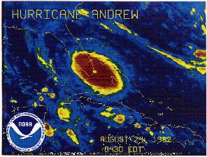
 Radar image of Andrew at landfall. (courtesy of NOAA/AOML)  Satellite image of Andrew at landfall.  The intense winds within Andrew's eyewall brought complete destruction to locations in its path, pictured here is the Lakes by the Bay subdivision. |
||||
|
Additional Information |
|||||