
Strong to severe thunderstorms will continue tonight across portions of the Ohio Valley into the Mid-Atlantic. Heavy rains may bring an isolated flash flooding threat over the central Appalachians, particularly in West Virginia. Moderate to heavy snow will continue over portions of northern Minnesota and the Upper Peninsula of Michigan through Tuesday morning. Read More >
| Snow Amount Potential
Experimental - Leave feedback
|
|
| Expected Snowfall - Official NWS Forecast
What's this? |
High End Amount 1 in 10 Chance (10%) of Higher Snowfall What's this? |
| Low End Amount 9 in 10 Chance (90%) of Higher Snowfall What's this? |
|
| Percent Chance That Snow Amounts Will Be Greater Than...
Experimental - Leave feedback
What's this?
|
||||||||||||||||
|
||||||||||||||||
| Snowfall Totals by Location
Experimental - Leave feedback
What's this?
|
|
|
| Ice Accumulation Potential
|
|
Expected Ice Accumulation - Official NWS Forecast This is the elevated flat surface ice accumulation. It is not radial/line ice. Radial/line ice is typically 39% of the elevated flat surface ice. For more information on this, see this module. |
|---|
 What's this? |
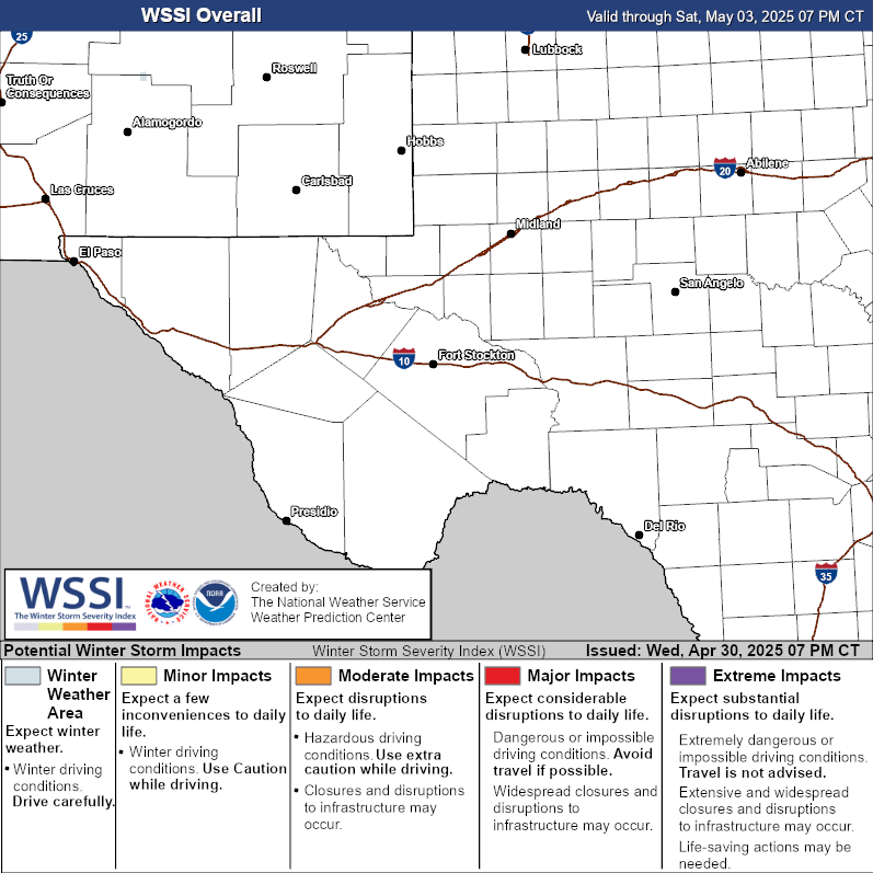
| Winter Storm Severity Index (WSSI) | Winter Storm Outlook (WSO) |
|---|---|
 |
 |
| National Snow Reports | National Snowfall Analysis |
|---|---|
 |
 |
| Local Snow Reports | |
 |
|
| Days 4-7 Winter Weather Outlook | |
| Day 4 Winter Weather Outlook | Day 5 Winter Weather Outlook |
 |
 |
| Day 6 Winter Weather Outlook | Day 7 Winter Weather Outlook |
 |
 |
| CPC Week-2 Experimental Heavy Snow Risk | |
 |
|
| CPC Temperature & Precipitation Maps | |
|
Days 6-10 |
|
| Temperature | Precipitation |
 |
 |
|
Days 8-14 |
|
| TEMPERATURE | PRECIPITATION |
 |
 |
|
Week 3-4 |
|
|
TEMPERATURE |
PRECIPITATION |
 |
 |
| Wind Chill Chart Excessive Rainfall Winter Weather (day 1) Winter Weather (day 2) Winter Weather (day 3) |
| Texas Road Conditions | (800) 452-9292 | |
| New Mexico Road Conditions | (800) 432-4269 | |
| Nationwide Road Conditions | ||
| NWS Winter Storm Safety | ||
Note: Some products are not issued routinely. Please check the date and time carefully.

