
A storm system shifting across the Great Lakes will bring light to moderate snow over parts of region today. Further south, scattered showers and thunderstorms are expected along and ahead of a cold front from Michigan to east Texas. Gusty winds and dry conditions will produce elevated to critical fire weather over the central High Plains today. Red Flag Warnings have been issued. Read More >
Midland/Odessa
Weather Forecast Office
| Submit Your Storm Report | NWS Midland/Odessa Local Storm Reports (LSR) |
|
Mesoscale Discussions
 |
Current Watches
 |
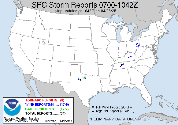
Severe Weather Reports
 |
|
|
Day 1 Outlook
 |
Day 2 Outlook
 |
Day 3 Outlook
 |
|
| Radar Sites Midland, TX El Paso, TX Lubbock, TX Dyess AFB, TX San Angelo, TX Laughlin AFB, TX |
 |
Regional Mosaics Southern Plains Southern Rockies Northern Rockies Northern Plains |
 |
| Tornado Warning (a tornado is occuring or imminent) Severe Thunderstorm Warning (a severe thunderstorm is occuring or imminent) Severe Weather Statement (updates tornado and severe thunderstorm warnings) Flash Flood Warning (flash flooding is occuring or imminent) Flash Flood Statement (updates flash flood warning) Watch by County Notification (list of counties within a convective watch) Significant Weather Advisory (strong but less than severe thunderstorms) Local Storm Reports (preliminary summary of severe weather reports) Storm Data (official publication of significant weather events) |
Hazards
Spotter Briefing
Outlook
Current Hazards
Storm Report
Severe Weather
Drought
Storm Prediction Center
Weather Prediction Center
National Hurricane Center
Active Alerts
Winter Weather
Past Weather
Cooperative Observations
Local Climate Data
National Climate
Current Weather
Observations
Satellite
Upper Air
West Texas Mesonet
Radar
Forecasts
Activity Planner
Aviation
Climate Prediction Center
Fire
Forecast Discussion
Graphical
Local
Space Weather Center
Information Center
Weather Trivia
Forecast Models
GIS
International Weather
Glossary
Road Conditions
Water
Hydrology
Precipitation Estimates
Quantitative Precipitation Forecasts
US Dept of Commerce
National Oceanic and Atmospheric Administration
National Weather Service
Midland/Odessa
2500 Challenger Dr.
Midland, TX 79706-2606
(432) 563-5006
Comments? Questions? Please Contact Us.

