
Severe thunderstorms are forecast through this weekend along a slow moving cold front and secondary storm system that will impact areas from the southern Plains to the Great Lakes. Large hail and isolated damaging wind gusts are the main threats with these storms along with a risk for heavy to excessive rainfall which could bring flooding. Read More >
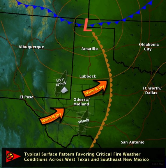
A period of much above normal temperatures, an escalating drought, record dry vegetation, persistently low relative humidity, and storm tracks favoring windy conditions have all been factors contributing to the development and spread of numerous wildfires across west Texas and southeastern New Mexico late this past winter and this spring, particularly during the wildfire outbreaks of February 27, March 22, April 9, and April 14.
Temperatures during the month of March averaged 6.0 degrees higher than normal at the Midland International Airport, and so far April has averaged 7.5 degrees above normal (as of April 17, 2011). The latest U.S. Drought Monitor valid as of April 12, 2011 places all of west Texas in Extreme (D3) Drought, while some locations across the southwestern Permian Basin, the upper Trans Pecos and Stockton Plateau, the Davis Mountains, and the Marfa Plateau have been included in the most significant drought category – Exceptional (D4).

Likewise, most of Eddy and Lea counties in southeastern New Mexico have been placed in Extreme (D3) Drought.

Though it may now seem like a distant memory, above normal precipitation fell across west Texas and southeastern New Mexico in 2010. This resulted in the green-up and heavy growth of vegetation over the region. With the escalating drought in progress, the vegetation across west Texas and southeastern New Mexico is now at unprecedentedly dry levels. The latest 1000-hour fuel moisture map from the Texas Forest Service shows just how dry it really is across our area. The 1000-hour fuel moisture reflects an average of the amount of moisture in fuels (dry vegetation) over an extended period of time, and is computed from mean daily temperature, relative humidity, and precipitation. Most of west Texas falls in the very dry 4-10 percentile range, while portions of the Guadalupe Mountains, the upper Trans Pecos, and the Big Bend region are in the exceptionally dry <3 percentile range. The heavy fuel-loading has been prime for wildfire spread.

The following photo taken April 13, 2011 shows the very dry fuels located adjacent to the NWS Midland Forecast Office (image courtesy Greg Murdoch):

A series of potent upper level storm systems have also moved from the Rocky Mountains into the central Plains during the months of March and April. Very strong winds spreading across west Texas on the base of the most intense of these storm systems, combined with a tight pressure gradient along the associated deep surface low systems have contributed to periods of windy to very windy conditions across west Texas and southeastern New Mexico. The dryline has also pushed well east of the region on most of these days, allowing very dry air to spread through west Texas, with relative humidity values consistently falling well into the single digits.
All of these factors have contributed to numerous wildfires that have developed and spread across portions of west Texas and southeastern New Mexico during the past couple of months. Since February 25, approximately 543,000 acres of land have been consumed by wildfires in the Midland/Odessa Weather Forecast Office area of responsibility alone. The most significant of these wildfires have impacted Jeff Davis (191,066 total acres burned), Andrews (180,594 total acres burned), Lea (67,000 total acres burned), Pecos (44,675 total acres burned), Midland (16,500 total acres burned), and Brewster (10,855 acres burned) counties. On April 9, the Hickman wildfire claimed 34 structures in Midland county, and the Rockhouse wildfire in Jeff Davis county claimed approximately 23 structures near Fort Davis.
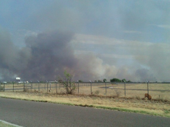
Photo of the Hickman Fire looking to the south of the NWS Midland Office (image courtesy Greg Jackson):
Another photo of the Midland county Hickman Fire (image courtesy Texas Forest Service):

The following image is a high-resolution MODIS satellite photograph taken April 15, 2011. Several wildfires were ongoing at the time this image was taken. Gusty northerly winds behind a cold front pushed the smoke plumes well to the south of the wildfire locations. The smoke plumes show up quite well on the satellite image. Burn scars from recent wildfires across portions of west Texas can also be seen in the image, and are highlighted in the red outlines.

Close-up satellite image of the Rockhouse and Roper fire burn scars:

The National Weather Service Office in Midland, Texas has been providing fire weather decision support to the Texas Forest Service, emergency management officials, and other decision makers at incident command posts across west Texas during this active wildfire season. NWS Midland meteorologists began participating in conference calls with the Texas Forest Service in January 2011. Since February 22, meteorologists have routinely provided daily fire weather briefings to Texas Forest Service officials and fire crews staged in Midland. Special emphasis has been given during the high impact, extremely critical fire weather patterns. NWS Midland incident meteorologist Greg Murdoch has also provided many hours of support for decision makers while dispatched at incident command posts staged in Merkel, TX and Midland, TX during the months of March and April.
Tactical slide used by NWS Midland meteorologist Greg Murdoch during a fire weather decision support briefing provided for local officials on April 12, 2011:


