
A heat wave over the Southwest will intensify this week, peaking and expanding into the Intermountain West and northern High Plains this weekend. Critical to extremely critical fire weather conditions are forecast from the Northwest and the northern Great Basin this weekend. Particularly Dangerous Situation Red Flag Warnings have been issued. Read More >
Reeves/Pecos Tornado Rated as EF-2
During the late afternoon on Sunday, May 23, an isolated thunderstorm developed over portions of southern Reeves County. As this thunderstorm moved southeastward, it intensified into a supercell thunderstorm - just west of the Reeves and Pecos County line.
The following is a base reflectivity radar image showing the supercell thunderstorm. Primary indications are that this tornado developed at approximately 6:56 pm CDT.

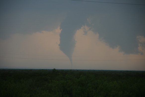
At approximately 6:58 pm, NWS employee Mike Hardiman took the following image of a well developed tornado:

The tornado continued to move southeastward, damaging a total of 12 power poles along its path. Each of these poles was 55 feet in height. All but two poles were broken into 3 or 4 pieces each, while the remaining two were snapped at the based. The broken poles are indicative of EF-2 type damage with winds estimated of approximately 120 mph.
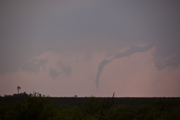
At 7:02 pm CDT, Pecos County Sheriff's Deputy Brandon Moore was also able to capture images of this tornado. While still well developed, the tornado was showing a thinning condensation funnel.
Finally, at approximately 7:06 pm CDT, Mike Hardiman captured the tornado in its final moments of life.
The following Google image shows the entire track of the tornado. Only in its final stages did the tornado move into extreme western portions of Pecos County. Click on the image for more detail.

Also seen on the image is damage just south of Interstate-10. At this location, a total of 8 more power poles were damaged. These poles – 35 feet in height - sustained a variety of damage. Some of the poles were damaged near their tops, while others were damaged 10 feet above the ground. Based on the damage and radar information, primary indications are that at location, damage was not directly caused by the tornado. Rather it was a combination of strong inflow winds into the approaching supercell thunderstorm and rear flank downdraft winds rounding the southern periphery of the storm that resulted in this damage.
The National Weather Service survey determined that there was only one tornado on May 23, 2010. The total length of the tornado track was determined to be approximately 4 miles, with its greatest width being approximately 300 yards wide.
Due to the aforementioned damage, a loss of electrical power from a power substation located along Interstate-10 resulted in the communities of Balmorhea, Saragosa, and Verhalen losing electrical service. This power outage lasted as long as 17 hours in some locations.

