
A few severe thunderstorms with large hail, are expected across parts of the middle and upper Mississippi River Valley tonight through early morning. Snow and a wintry mix overnight in the Upper Midwest into the Great Lakes can cause hazardous travel conditions. Fire weather concerns continue for a large portion of the central and southern High Plains and Four Corners region this evening. Read More >
April 23, 2008 Northern Permian Basin Severe Weather
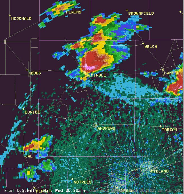
During the afternoon and early evening hours of April 23, supercell thunderstorms developed along and north of a warm front located from just south of Seminole to the Borden and Howard County line south of Gail. These supercell thunderstorms became the main focus of severe weather with a total of 8 tornadoes being confirmed by spotting groups from around the area.
A damage survey was conducted by the National Weather Service in Midland on Thursday, April 24 to confirm tornado reports and locate damage. Of the 8 tornadoes, 7 were determined to be EF0 weak tornadoes, with one tornado near Snyder rated as EF1 in intensity. The following is a summary of findings from the April 23, 2008 severe weather event.
The NWS damage survey, along with key information from experienced storm spotters and chasers, revealed the presence of two tornadoes in Scurry County during the afternoon of April 23.
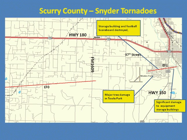
Storm chasers identified and photographed a weak tornado west southwest of the city of Snyder-- south of the Union community -- between 2:34 pm and 2:42 pm. The NWS survey conducted by WFO Midland did confirm power pole damaged approximately 2.8 miles south of the Union community along Farm to Market Road 1609. This tornado damage was indicative of EF0 intensity. Based on radar imagery and storm speed, primary indications are that the tornado path extended to the west of Farm to Market Road 1609 for approximately 4-6 miles. The width of the tornado is estimated at 50 yards.
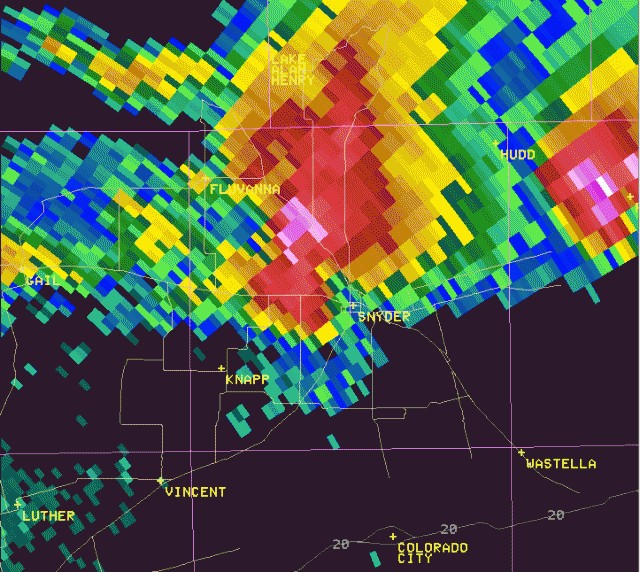
Communication with the Scurry County airport representatives at Winston Field revealed that the tornado did not cross the airport property, with the first weak tornado likely dissipating just east of Farm to Market Road 1609. This is supported by evidence of a second tornado and slightly stronger tornado developing just west of the Towle Park area, south of 37th street around 2:50 pm CDT. In Towle Park, large trees were uprooted. At the nearby High School, a 20x40 storage building adjacent to the school was rolled and destroyed. The new football scoreboard was also demolished. The uprooting of well established trees in Towle Park and the damage observed to the storage building at Snyder High School are indicative of EF1 tornado damage. EF1 damage was also observed along Voss Lane near the end of the Snyder tornado life cycle, where metal farm buildings sustained significant damage. Wind speeds for this tornado are estimated at 90-100 mph, which is believed to have stayed on the ground for approximately 3 ½ minutes, travelling approximately 1.75 miles. The tornado width is estimated at 100 yards.
A 59 mph wind gust from the north was measured at Winston Field at 3:05 pm. A 69 mph wind gust from the northwest was measured at the Texas Tech Mesonet station located 3 miles east of Snyder at 3:10 pm. In both cases, these wind gusts occurred after the tornadic supercell thunderstorm had already moved east of the area.
In southern portions of Dawson County, two tornadoes were observed, with a high probability of the occurrence of a third tornado.
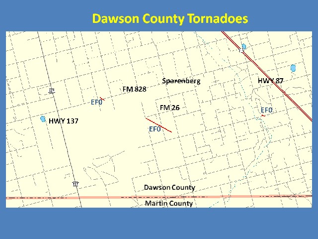
The NWS damage survey viewed images of a tornado 2 ½ miles west southwest of Sparenberg along Farm to Market Road 828. Greg Morgan, local television meteorologist and spotter, provided visual confirmation of this weak tornado lasting approximately one minute. Mr. Morgan and other eyewitnesses estimated a tornado touchdown time of 3:45 pm CDT, and radar imagery confirmed this estimate.
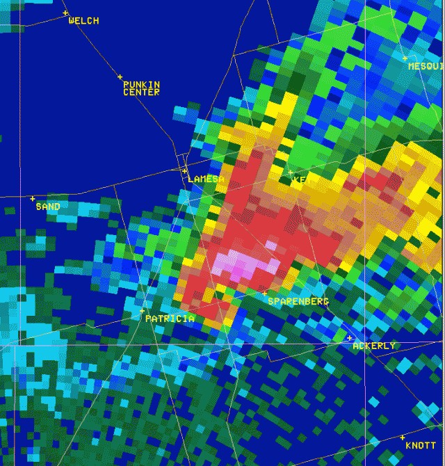
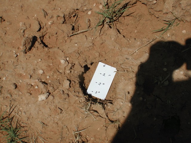
Members of the Texas Tech Atmospheric Science Group and Greg Morgan from CBS 7 in Odessa witnessed the second tornado, which developed at 3:56 pm CDT, approximately 1 ½ miles southwest of Sparenberg over open country, and continued until 4:00 pm. The tornado dissipated approximately 1.75 miles south of Sparenberg, just west of Farm to Market Road 26. The Texas Tech Atmospheric Science Group also witnessed a well defined funnel -- potentially a third tornado located approximately 4 ½ miles northwest of Ackerly. However, the group could not verify the tornado touchdown. For the purposes of this damage survey write-up, WFO Midland will include this as a tornado. Radar imagery indicated a best time estimate for this third tornado at 4:08 pm CDT. Since the tornadoes remained primarily over open country, the NWS damage survey team could not associate significant damage with any of the three tornadoes. Thus, EF0 ratings will be assigned to these weak tornadoes. In addition to the tornadoes, up to softball size hail was reported in southeast portions of the city of Lamesa. Photos of hail crater impressions found in the mud are provided below by John Lipe, meteorologist from the National Weather Service in Lubbock.
Video of a tornado in Gaines County, just west of U.S. Highway 385 and 2 ½ miles south of Seminole, was provided to the KWES NewsWest 9 television station in Midland. Robert Barrett, Gaines County Emergency Manager, also provided images of the tornado as it crossed Highway 385 and headed eastward.
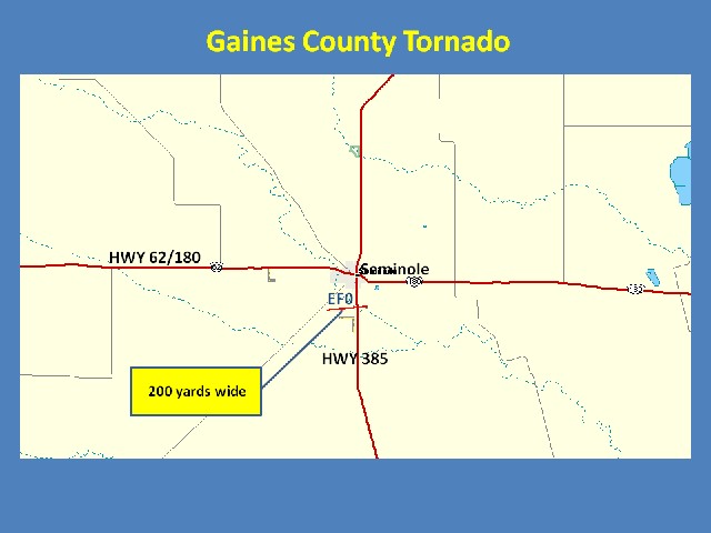
Radar imagery indicated the most likely time range for the tornado was between 3:56 pm to 4:02 pm CDT. Tornado width was estimated at 200 yards and an EF0 intensify rating has been assigned for this tornado.
Brief tornado touchdowns were also reported by spotters near Patricia at 5:29 pm CDT and also in Howard County near the community of Luther at 6:55 pm. These will also be entered as EF0 tornadoes.
The 8 tornadoes reported on April 23, 2008 is the most significant outbreak of tornadoes across the Permian Basin since the March 22, 2000 outbreak.

